Related Research Articles
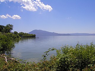
Lake County is a county located in the north central portion of the U.S. state of California. As of the 2010 census, the population was 64,665. The county seat is Lakeport. The county takes its name from Clear Lake, the dominant geographic feature in the county and the largest natural lake wholly within California.

Ahjumawi Lava Springs State Park is a state park of California in the United States. It is located in remote northeastern Shasta County and is only accessible to the public by boat.

The Folsom Lake State Recreation Area surrounds Folsom Lake in the foothills of the Sierra Nevada, and is managed by the California Department of Parks and Recreation. It is located near the city of Folsom, California, about 25 miles (40 km) east of Sacramento.

Lake Merced is a freshwater lake in the southwest corner of San Francisco, in the U.S. state of California. It is surrounded by three golf courses, as well as residential areas, Lowell High School, San Francisco State University, Lakeshore Alternative Elementary School, Stonestown Galleria, Fort Funston and the Pacific Ocean. The San Francisco Police Department shooting range, as well as a now closed skeet shooting club and the city's National Guard armory are also in the area. The lake is home of the Pacific Rowing Club and St. Ignatius College Prep Rowing Team, both competitive rowing programs for San Francisco high school students.

Ward Creek is a 6.1-mile (9.8 km) eastward-flowing stream in Placer County, California, USA. The creek flows into Lake Tahoe 2.7 miles (4.3 km) south of Tahoe City, California, and has undergone extensive restoration to reduce sediment and surface run-off to maintain the purity of Lake Tahoe.
Newberry Springs is an unincorporated community in the western Mojave Desert of Southern California, located at the foot of the Newberry Mountains in San Bernardino County, California, United States. The population at the 2000 census was 2,895.
The Timbisha are a Native American tribe federally recognized as the Death Valley Timbisha Shoshone Band of California. They are known as the Timbisha Shoshone Tribe and are located in south central California, near the Nevada border. As of the 2010 Census the population of the Village was 124. The older members still speak the ancestral language, also called Timbisha.

The Smoke Creek Desert is an arid region of northwestern Nevada, USA that lies about 60 miles (97 km) to the north of Pyramid Lake, west of the Fox Range and east of the Smoke Creek Mountains. The southern end of the desert lies on the Pyramid Lake Indian Reservation, and a rail line lies at the eastern edge. The Smoke Creek Desert is southwest of the Black Rock Desert's South Playa and is between the Granite Range and the Fox Range.
Crystal Springs Reservoir is a pair of artificial lakes located in the northern Santa Cruz Mountains of San Mateo County, California situated in the rift valley created by the San Andreas Fault just to the west of the cities of San Mateo and Hillsborough, and I-280. The lakes are part of the San Mateo Creek watershed.

Silverwood Lake is a large reservoir in San Bernardino County, California, United States, located on the West Fork Mojave River, a tributary of the Mojave River in the San Bernardino Mountains. It was created in 1971 as part of the State Water Project by the construction of the Cedar Springs Dam as a forebay on the 444 mi (715 km) long California Aqueduct, and has a capacity of 73,000 acre⋅ft (90,000,000 m3).

Alder Springs is an unincorporated community in Fresno County, California. It is located 5.5 miles (9 km) west-southwest of Shaver Lake Heights, at an elevation of 4426 feet.

Mono Hot Springs is a summer resort and campground at a group of hot springs in Fresno County, central California. It is located within the Sierra National Forest, 70 miles (110 km) northeast of Fresno via California State Route 168.
Gypsite is an unincorporated community in Kern County, California.
Miracle Hot Springs is an unincorporated community in the Kern River Valley, in Kern County, California. It is located along the Kern River in the SEQUOIA NATIONAL FOREST, KERN RIVER RANGER DISTRICT 10 miles (16 km)West of Lake Isabella, California, at an elevation of 2,382 feet (726 m).
Highland Springs is an unincorporated community in Lake County, California. It is located 5 miles (8 km) southwest of Kelseyville, at an elevation of 1483 feet.
Seigler Springs is an unincorporated community in Lake County, California. It is located 1 mile (1.6 km) east of Seigler Mountain, 5 miles (8 km) south of Clear Lake and 20 miles (32 km) northeast of Healdsburg, at an elevation of 2251 feet.
Witter Springs is a former settlement in Lake County, California. It was located 3 miles (4.8 km) northwest of Upper Lake, at an elevation of 1476 feet.
Brockway is an unincorporated community in Placer County, California. Brockway is located on the north shore of Lake Tahoe on State Line Point, adjacent to the Nevada state border. It lies at an elevation of 6266 feet.
Soda Springs is an unincorporated community in Placer County, California. Soda Springs is located on the North Fork of the American River, 4 miles (6.4 km) north-northwest of Granite Chief. It lies at an elevation of 6047 feet.
Mud Spring, formerly called Aquaje Lodoso, is a spring and historic site in the western Antelope Valley, within northern Los Angeles County, southern California.
References
- 1 2 3 Durham, David L. (1998). California's Geographic Names: A Gazetteer of Historic and Modern Names of the State. Clovis, Calif.: Word Dancer Press. p. 152. ISBN 1-884995-14-4.

| This Lake County, California–related article is a stub. You can help Wikipedia by expanding it. |