
El Dorado County, officially the County of El Dorado, is a county in the U.S. state of California. As of the 2010 census, the population was 181,058. The county seat is Placerville.

Mono County is a county located in the east central portion of the U.S. state of California. As of the 2010 census, the population was 14,202. making it the fifth-least populous county in California. The county seat is Bridgeport. The county is located east of the Sierra Nevada between Yosemite National Park and Nevada. The only incorporated town in the county is Mammoth Lakes, which is located at the foot of Mammoth Mountain. Other locations, such as June Lake, are also famous as skiing and fishing resorts. Located in the middle of the county is Mono Lake, a vital habitat for millions of migratory and nesting birds. The lake is located in a wild natural setting, with pinnacles of tufa arising out of the salty and alkaline lake. Also located in Mono County is Bodie, the official state gold rush ghost town, which is now a California State Historic Park.

Minneapolis–Saint Paul is a major metropolitan area built around the confluence of the Mississippi, Minnesota and St. Croix rivers in east central Minnesota. The area is commonly known as the Twin Cities after its two largest cities, Minneapolis, the most populous city in the state, and its neighbor to the east, Saint Paul, the state capital. It is an example of twin cities in the sense of geographical proximity. Minnesotans often refer to the two together simply as "the Cities."

San Marcos is a city in the North County region of San Diego County in the U.S. state of California. As of the 2010 census, the city's population was 83,781. It is the site of California State University San Marcos. The city is bordered by Escondido to the east, Encinitas to the southwest, Carlsbad to the west, and Vista to the northwest. Lake San Marcos is an enclave, or county island, in the southwestern part of the city, within San Marcos' sphere of influence but technically an unincorporated community.

Alluvium is loose, unconsolidated soil or sediment that has been eroded, reshaped by water in some form, and redeposited in a non-marine setting. Alluvium is typically made up of a variety of materials, including fine particles of silt and clay and larger particles of sand and gravel. When this loose alluvial material is deposited or cemented into a lithological unit, or lithified, it is called an alluvial deposit.

Fort Yargo State Park is a 1,816-acre (7.35 km2) Georgia state park located in Winder, situated between Athens and Atlanta. The park is located 1 mile south of Winder and is accessible by Georgia State Route 81. There is a 260-acre (1.1 km2) lake with a public beach. Available activities at Fort Yargo include GeoCaching, hiking, mountain biking, disc golf, boating, lake swimming, fishing, picnicking, and miniature golf. The park also features a log fort built in 1792 by settlers, for protection against the Creek and Cherokee.

State Route 189 is a state highway in the U.S. state of California that runs through the San Bernardino Mountains in San Bernardino County. The route travels from State Route 18 near Crestline to State Route 173 in Lake Arrowhead, serving Twin Peaks and Blue Jay along its way.

Ward Creek is a 6.1-mile (9.8 km) eastward-flowing stream in Placer County, California, United States. The creek flows into Lake Tahoe 2.7 miles (4.3 km) south of Tahoe City, California, and has undergone extensive restoration to reduce sediment and surface run-off to maintain the purity of Lake Tahoe.
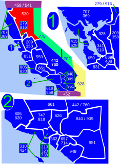
Area code 530 is a California telephone area code in northeastern and Northern California.

The Kaiser Wilderness is a federally designated wilderness protected area located 70 miles (110 km) northeast of Fresno in the state of California, USA. It was added to the National Wilderness Preservation System by the United States Congress on October 19, 1976. The wilderness is 22,700 acres (92 km2) in size, is one of five wilderness areas within the Sierra National Forest and is managed by the US Forest Service.
Twin Lakes, California may refer to one of these communities:

Mono Village is a community in Mono County, California. It is located 11 miles (18 km) southwest of Bridgeport, at an elevation of 7142 feet. It is part of the Twin Lakes census-designated place.
The Middletown Rancheria of Pomo Indians of California is a federally recognized tribe of Pomo Indians, as well as some Wappo and Lake Miwok Indians, in California, headquartered in Middletown, California.

Twin Lakes State Beach is a beach located on Monterey Bay directly south of the Santa Cruz Yacht Harbor Santa Cruz, in coastal Santa Cruz County, northern California.
Twin Peaks is an unincorporated community in San Bernardino County, California, United States, located on California State Route 189 2.5 miles (4.0 km) west-southwest of Lake Arrowhead. Twin Peaks has a post office with ZIP code 92391, which opened in 1916.
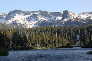
Twin Lakes is a set of connected lakes at the base of the southeastern slope of Mammoth Mountain, in Mono County of eastern California. They are in the eastern Sierra Nevada, and within the Inyo National Forest.

The Clayton Fire was a wildfire that started on August 13, 2016 just south of Lower Lake in Lake County, California. The fire burned a total of 3,929 acres (15.90 km2) and destroyed 300 buildings, before it was fully contained on August 26. Damin Pashilk, a construction worker from Clearlake was arrested and facing 17 counts of arson related to the Clayton Fire and other fires.
Twin Lakes in Mono County, California can refer to:
Twin Lakes is a census-designated place (CDP) in Mono County, California, United States. It is located on the east side of the Sierra Nevada, encompassing the lakes of the same name and extending north down the outlet valley of Robinson Creek. The community of Mono Village is within the CDP. The area is part of Toiyabe National Forest and is 10 miles (16 km) southwest of Bridgeport. It was first listed as a CDP prior to the 2020 census.


