Boseong County

Last updated
Boseong
보성군
Korean transcription(s)
  Hangul보성군
  Hanja
  Revised RomanizationBoseong-gun
  McCune-ReischauerPosŏng-gun
Korea-Boseong-Green.tea-02.jpg
Green tea field in Boseong
Flag of Boseong.svg
Boseong County logo.png
South Jeolla-Boseong.svg
Location in South Korea
CountryFlag of South Korea.svg  South Korea
Region Honam
Administrative divisions 2 eup, 10 myeon
Area
  Total663.16 km2 (256.05 sq mi)
Population
 (2001)
  Total61,329
  Density92/km2 (240/sq mi)
  Dialect
Jeolla

Boseong County (Boseong-gun) is a county in South Jeolla Province, South Korea. Boseong is famous for its green tea leaves, with 26.71 hectares of land dedicated to its production. [1] It is also the birthplace of the Korean independence activist Philip Jaisohn.

Contents

History

In the Samhan era, Boseong belonged to the Mahan confederacy and later became Bokhol County (伏忽郡) under the rule of the Baekje dynasty. The name "Boseong" was given in Unified Silla. [2]

Geography

Large areas consist of mountains such as Mangil-Bong, Jonje Mountain and Joowol Mountain. The Boseong River flows through the center of Boseong. The multipurpose Juam Dam was built on the Boseong River in 1990.

Climate

Boseong is one of the rainiest places in South Korea. It has a moderate climate. The average annual temperature is 12.6 °C. The average temperature in January is −0.5 °C and the average temperature in August is 27.8 °C. Annual mean precipitation is 1,450 mm.

Climate data for Boseong (1993–2020 normals)
MonthJanFebMarAprMayJunJulAugSepOctNovDecYear
Mean daily maximum °C (°F)5.4
(41.7)
8.0
(46.4)
12.9
(55.2)
18.4
(65.1)
23.2
(73.8)
25.9
(78.6)
28.3
(82.9)
29.7
(85.5)
26.3
(79.3)
21.4
(70.5)
14.5
(58.1)
7.6
(45.7)
18.5
(65.3)
Daily mean °C (°F)−0.2
(31.6)
1.8
(35.2)
6.1
(43.0)
11.6
(52.9)
16.8
(62.2)
20.7
(69.3)
24.2
(75.6)
25.0
(77.0)
20.5
(68.9)
14.1
(57.4)
7.6
(45.7)
1.7
(35.1)
12.5
(54.5)
Mean daily minimum °C (°F)−5.1
(22.8)
−3.7
(25.3)
−0.2
(31.6)
5.0
(41.0)
10.9
(51.6)
16.5
(61.7)
21.1
(70.0)
21.5
(70.7)
16.1
(61.0)
8.1
(46.6)
1.7
(35.1)
−3.7
(25.3)
7.4
(45.3)
Average precipitation mm (inches)24.8
(0.98)
47.9
(1.89)
80.3
(3.16)
126.6
(4.98)
151.3
(5.96)
190.3
(7.49)
286.0
(11.26)
312.6
(12.31)
172.3
(6.78)
74.5
(2.93)
48.1
(1.89)
27.5
(1.08)
1,542.2
(60.72)
Average precipitation days (≥ 0.1 mm)5.15.37.07.98.48.512.611.88.34.86.45.691.7
Source: Korea Meteorological Administration [3]

Administrative district

Boseong consists of two towns-Boseong town and Beolgyo town. Every town of population is gradually decreased.

Boseong Green Tea

Boseong Green Tea is a special product produced in Boseong district.

Boseong County is the largest tea-producing area in Korea. It is so called as to be called as DongguyeojI-Seungnam (meaning " tea house " in the Joseon Dynasty). Tea produced in Boseong County is still active in growing tea plants, accounting for 40 percent of the nation's tea production. [4]

Boseong is known as the green tea capital of Korea. The surrounding climate and soil provide good conditions for growing a unique green tea that has a distinct taste and aroma. [1] Almost one third of all tea farmland is located in Boseong, and nearly half of all green tea production in Korea comes from the area. This status has been carefully crafted in recent decades, partly due to the long history green tea has with the area. [1]

Green tea has been produced in Boseong for the past 1600 years. [1] The earliest historical mention of green tea in Korea was from the reign of Queen Seondeok of Silla in the mid-7th century AD. [5] Nearly two hundred years later, historical records indicate green tea seeds were planted at the foot of nearby Jirisan Mountain. [5] During the Joseon dynasty, green tea began to fall out of favor due to its close association with Buddhism, but was still enjoyed by certain parts of the population and the Jirisan plantation continued to thrive. [5] But it was not until the 1930s that green tea was produced on a large-scale basis. By the 1970s, huge, terraced farms as large as 250 acres became commonplace among local mountainsides. [1] The 1980s marked the beginning of a decline in green tea demand which resulted in lower green tea output and a degradation of crops. [1] It was then that the local government decided to reinvigorate the green tea industry by subsidizing local green tea businesses and developing newer, more efficient means to increase output and quality by collaborating with local universities and research institutes. [1] Local media outlets also made efforts to paint Boseong as the green tea capital of the country to increase dominance in the industry by local businesses and draw in tourists from around the country. [1]

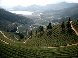
Mt. Hwangseong features the largest plantation in Boseong, the Daehan Green Tea Plantation. [5] This plantation is responsible for over one third of all tea production in the area. The mountainside features a terraced design that extends along the lower reaches of the mountain and is carefully manicured, providing an impressive view when seen from the top. [6] This view is accessible by road and has become a famous stop for tourists. The Boseong Fragrance Tea Festival is also staged in May of each year and 2013 will mark the 38th year of the festival. The festival gives tea enthusiasts the chance to pick tea leaves, make tea bowls or sample local cuisine infused with green tea flavoring. [6]

Boseong Green Tea passed the strict quality inspection of the Russian Medical Biology Lab, and was officially recognized as a beverage suitable for an astronaut's special diet.

Transportation

National Road No. 2 goes through Boseong, and the Gyeongjeon Line transits several towns. There are mainly five stations including Boseong station, Dukryang Station, Yedang Station, Joseong Station and Beolgyo Station. Coastal region has well-connected transportation. However, inland of Boseong has a poor transportation because of mountains.

Notable people

Twin towns – sister cities

Boseong is twinned with:

Related Research Articles

<span class="mw-page-title-main">North Jeolla Province</span> Province of South Korea

Jeonbuk State, also known as Jeonbuk is a Special Self-governing Province of South Korea in the Honam region in the southwest of the Korean Peninsula. Jeonbuk borders the provinces of South Chungcheong to the north, North Gyeongsang and South Gyeongsang to the east and South Jeolla to the south.

<span class="mw-page-title-main">Jeonju</span> City in North Jeolla, South Korea

Jeonju is the capital and largest city of Jeollabuk-do, South Korea. It is both urban and rural due to the closeness of Wanju County which almost entirely surrounds Jeonju. It is an important tourist center famous for Korean food, historic buildings, sports activities, and innovative festivals.

<span class="mw-page-title-main">Hoengseong County</span> County in Gwandong, South Korea

Hoengseong County is a county located in southwestern Gangwon Province, South Korea, bordering Pyeongchang-gun to the east, Yangpyeong-gun, Gyeonggi-do to the west, Hongcheon-gun to the north, and Wonju-si and Yeongwol-gun to the south.

<span class="mw-page-title-main">Inje County</span> County in Gwandong, South Korea

Inje County is a county in Gangwon Province, South Korea. It has the lowest population density of any South Korean county. The county seat is Inje-eup, which located in towards the center of the county.

<span class="mw-page-title-main">Gurye County</span> County in Honam, South Korea

Gurye (Gurye-gun) is a county in the province of Jeollanam-do, South Korea. Gurye is a small, picturesque farming town situated between Jirisan and the Seomjin River. In the northeastern part of unwavering efforts at the Mt. Jiri. Gurye is the sole designated special tourism and leisure zone in all of Jeollanam-do. The total size of Gurye County is 443.02 square km, with a modest population of approximately 30,000.

<span class="mw-page-title-main">Gochang County</span> County in Honam, South Korea

Gochang County is a county in North Jeolla Province, South Korea. It is a rural area, and is home to only one institution of higher education: Gochang Polytechnic College.

<span class="mw-page-title-main">Pocheon</span> Municipal City in Gyeonggi Province, South Korea

Pocheon (Korean pronunciation:[pʰo.tsʰʌn]) is an inland city in the far northeastern region of Gyeonggi province in South Korea. It covers 826.48 km (513.55 mi)2 with a population of 160,176 people, according to the 2008 census. Pocheon lies between Seoul and the mountainous northwestern areas of Gangwon province. The city borders Yeoncheon county, with the cities of Dongducheon and Yangju to the west, along with Uijeongbu, and Namyangju of Gyeonggi province to the south. It also borders Hwacheon county of Gangwon province on its eastern border and Cheorwon is to the north. Alongside the adjoining Gapyeong, Pocheon consists of the highest mountainous areas in Gyeonggi province. The current city of Pocheon was created after Pocheon-hyeon and Yeongpyeong counties were merged. The north part of the city used to be part of Yeongpyeong county while the south used to be part of Pocheon-hyeon.

<span class="mw-page-title-main">Nonsan</span> Municipal City in Hoseo, South Korea

Nonsan is a city in South Chungcheong Province, South Korea. It is located at 36°12′N127°5′E. The origin of Nonsan's geographical names is said to have come from the small garden " Nolmoe, " which rises in the middle of farming fields, where rice paddies and mountain are said to reflect geographical features. The city belongs to the Daejeon Metropolitan Area.

<span class="mw-page-title-main">Geumsan County</span> County in South Chungcheong Province, South Korea

Geumsan County is a county in South Chungcheong Province, South Korea. It borders Muju County, North Jeolla Province (Jeollabuk-do), which is famous for its ski resort nearby.

<span class="mw-page-title-main">Gimcheon</span> Municipal City in Yeongnam, South Korea

Gimcheon is a city in North Gyeongsang Province, South Korea. It is situated on the major land transportation routes between Seoul and Busan, namely the Gyeongbu Expressway and Gyeongbu Line railway.

<span class="mw-page-title-main">Mungyeong</span> Municipal City in Yeongnam, South Korea

Mungyeong is a city in North Gyeongsang Province, South Korea. The local government, economy, and transportation networks are all centered in Jeomchon, the principal town. Mungyeong has a lengthy history, and is known today for its various historic and scenic tourist attractions. The city's name means roughly "hearing good news." Recently, development has been somewhat stagnant with the decline of the coal industry. Since the 1990s, the proportion of people who rely on the tourism industry through Mungyeong Saejae has gradually increased.

<span class="mw-page-title-main">Hadong County</span> County in Yeongnam, South Korea

Hadong County is a county in South Gyeongsang Province, South Korea. It is on the far-west side of the province, bordering South Jeolla Province. The county office is located at Hadeong-eup.

<span class="mw-page-title-main">Hamyang County</span> County in Yeongnam, South Korea

Hamyang County (Hamyang-gun) is a county in South Gyeongsang Province, South Korea.

<span class="mw-page-title-main">Sancheong County</span> County in Yeongnam, South Korea

Sancheong County (Sancheong-gun) is a county in South Gyeongsang Province, South Korea.

<span class="mw-page-title-main">Korean tea ceremony</span>

The Korean tea ceremony is a traditional form of tea ceremony practiced in Korea. Darye literally refers to "etiquette for tea" or "tea rite" and has been kept among Korean people for over a thousand years. The chief element of the Korean tea ceremony is the ease and naturalness of enjoying tea within an easy formal setting.

<span class="mw-page-title-main">History of Seoul</span> Historical account of Seoul

The history of Seoul can be traced back as far as 18 BC, although humans have occupied the area now known as Seoul since the Paleolithic Age. It has been the capital of numerous kingdoms on the Korean Peninsula since it was established.

<span class="mw-page-title-main">Pangyo, Seongnam</span> Planned district of Seongnam, South Korea

Pangyo or Pangyo New Town is a planned district composed of several dongs or neighborhoods of Seongnam, South Korea. It contains Pangyo-dong, Baekhyeon-dong, Unjung-dong, and Sampyeong-dong of Bundang-gu and Siheung-dong and Sasong-dong of Sujeong-gu.

<span class="mw-page-title-main">Samnyeonsanseong</span>

Samnyeon Sanseong Fortress is the ruins of a Silla fortress and wall that was built beginning in the year 470. The fortress was reconstructed in 486. The ruins are located in present-day Boeun, South Korea. During the Three Kingdoms Period the town of Boeun-eup, located two kilometers from the fortress, was known as Samnyeon-gun or Samnyeonsan-gun and it is believed by some that the fortress gets its name from the town. However, the Samguk Sagi relates that the fortress was completed in three years, and that the fortress derived its name from this fact. This account also suggests that the nearby town derived its name from the fortress, rather than vice versa. The Annals of Joseon Dynasty show that the fortress was known as Ojeong Sanseong Fortress and was used during the Joseon Dynasty, probably because the fortress is located atop Mount Ojeongsan.

<span class="mw-page-title-main">Korean tea</span>

Korean tea is a beverage consisting of boiled water infused with leaves, roots, flowers, fruits, grains, edible mushrooms, or seaweed. It may or may not contain tea leaves.

<span class="mw-page-title-main">Bogwang-dong</span> Place in South Korea

Bogwang-dong is a dong (neighbourhood) of Yongsan-gu in Seoul, South Korea.

References

  1. 1 2 3 4 5 6 7 8 Suh, Jeongwook; MacPherson, Alan (December 2007). "The impact of geographical indication on the revitalisation of a regional economy: a case study of 'Boseong' green tea". Area. 39 (4): 518–527. doi:10.1111/j.1475-4762.2007.00765.x. JSTOR   40346073.
  2. Boseong County homepage (English) Archived October 9, 2010, at the Wayback Machine
  3. "Climatological Normals of Korea (1991 ~ 2020)" (PDF) (in Korean). Korea Meteorological Administration. Archived from the original (PDF) on 29 January 2022. Retrieved 7 June 2023.
  4. "Boseong". Doosan Encyclopedia .
  5. 1 2 3 4 "Korea’s Rolling Hills of Green Tea in Boseong" 2008 Archived December 13, 2014, at the Wayback Machine
  6. 1 2 Pilgrimage to Korea’s tea country, Volume 27, Issue 1, Koreana, 2013, p. 69
  7. "South Korea's president appears to be threading the needle between ..." Los Angeles Times. Retrieved 18 September 2018.

34°46′N127°05′E / 34.767°N 127.083°E / 34.767; 127.083