Muan County

Last updated
Muan
무안군
Korean transcription(s)
   Hangul 무안군
   Hanja
  Revised RomanizationMuan-gun
  McCune-ReischauerMuan-gun
Muan International Airport 20190523 091558.jpg
Flag of Muan.svg
Muan logo.png
South Jeolla-Muan.svg
Location in South Korea
CountryFlag of South Korea.svg  South Korea
Region Honam
Administrative divisions 2 eup, 7 myeon
Area
  Total436.4 km2 (168.5 sq mi)
Population
 (December 2011)
  Total75,718
  Density173.50/km2 (449.4/sq mi)
  Dialect
Jeolla
Area code(s) +82-61-2xx,450~459

Muan County (Muan-gun) is a county in South Jeolla Province (Jeollanam-do), South Korea. In 2005, Muan County became the capital of Jeollanam-do following the transfer of the provincial office from its previous location, Gwangju to the village of Namak in Muan. Muan International Airport was opened here, and will eventually replace the airports in Gwangju and Mokpo. [1]

Contents

Modern history

On January 1 of 1963, several villages (ri in Korean) were incorporated into Mokpo city and huge reorganization was made by Korean government. [2] In 1979, Muan township was promoted to a township (eup of South Korea). In 1980, Illo was also promoted into a township. [3]

Symbols

Location

Muan County is located on the western tip of the South Western part of the Korean peninsula. It acts as the primary link between Sinan county with the rest of the Korean mainland. Numerous beaches are also found on Muan's coast.

Muan borders Yeongsan river with Naju and Hampyeong to the north, Yeongam to the east, Mokpo to the south. These surroundings have influenced the industrial and cultural structure of Muan County. [4]

Enterprise city

Muan was designated an enterprise city by the South Korean government for the Honam region (Southwest). The South Korean government and China have agreed to develop an industrial complex in a joint venture. It was reported that the Chinese government officially promised to invest in and help establish the complex area, which includes the construction of a college and distribution warehouses among other things such as a Chinatown for expatriates. [5]

Mud

Muan includes a large area of mudlands. The western area of the Korean peninsula has a large amount of mud thanks to the Rias coast. However, many mudlands have been destroyed or reclaimed for expanding city areas or industrial complexes.

The mudlands of Muan were designated one of the wetlands of the Ramsar Convention.

In the Muan mudflats, tourists can not enter the sea without permission to protect the mudflats. But, tourists can see the road that opens like the " Miracle of Moses " to reveal its face when the tide falls twice a day. [6]

Festival

Muan is widely known for its White Lotus Festival (무안연꽃축제) located in Illo-eup. [7] The festival occurs in mid August when the white lotus flowers bloom fully onsite at the Hoesan White Lotus Pond (회산 백련지). [8] Tourists can walk into the huge lotuslands via the many bridges that crisscross the water. Visitors may also ride the 'duck boats.'

Products

Muan is known for several famous products characteristic of the area. They are largely farming goods from onions to lotus products. Muan puts out 16% of the national onion production making its production volume the largest in Korea. [9]

Muan county officially reported to host farming cluster of sweet potato, onion and lotus plants. The powder of lotus plants is used for making noodles.

Education

Muan County is the site of Mokpo National University, situated in Cheonggye township.

Climate

Climate data for Muan (2001–2020 normals)
MonthJanFebMarAprMayJunJulAugSepOctNovDecYear
Mean daily maximum °C (°F)5.0
(41.0)
7.3
(45.1)
11.9
(53.4)
17.7
(63.9)
23.3
(73.9)
26.7
(80.1)
29.1
(84.4)
30.5
(86.9)
26.7
(80.1)
21.2
(70.2)
14.3
(57.7)
7.3
(45.1)
18.4
(65.1)
Daily mean °C (°F)0.8
(33.4)
2.4
(36.3)
6.4
(43.5)
11.8
(53.2)
17.4
(63.3)
21.7
(71.1)
25.2
(77.4)
26.1
(79.0)
21.6
(70.9)
15.5
(59.9)
9.2
(48.6)
2.8
(37.0)
13.4
(56.1)
Mean daily minimum °C (°F)−3.1
(26.4)
−2.0
(28.4)
1.3
(34.3)
6.2
(43.2)
12.2
(54.0)
17.8
(64.0)
22.2
(72.0)
22.7
(72.9)
17.6
(63.7)
10.4
(50.7)
4.5
(40.1)
−1.1
(30.0)
9.1
(48.4)
Average precipitation mm (inches)29.6
(1.17)
41.7
(1.64)
56.4
(2.22)
96.7
(3.81)
96.5
(3.80)
143.6
(5.65)
271.3
(10.68)
249.0
(9.80)
145.4
(5.72)
72.3
(2.85)
47.9
(1.89)
39.7
(1.56)
1,290.1
(50.79)
Average precipitation days (≥ 0.1 mm)7.56.87.48.28.18.113.111.58.35.87.69.4101.8
Source: Korea Meteorological Administration [10]

Transportation

Expressway

National Route

Railway

Airport

Sister cities

Related Research Articles

<span class="mw-page-title-main">North Jeolla Province</span> Province of South Korea

Jeonbuk State, also known as Jeonbuk is a Special Self-governing Province of South Korea in the Honam region in the southwest of the Korean Peninsula. Jeonbuk borders the provinces of South Chungcheong to the north, North Gyeongsang and South Gyeongsang to the east and South Jeolla to the south.

<span class="mw-page-title-main">South Jeolla Province</span> Province of South Korea

South Jeolla Province, also known as Jeonnam, is a province in the Honam region, South Korea, and the southernmost province in mainland Korea. South Jeolla borders the provinces of North Jeolla to the north, South Gyeongsang to the northeast, and Jeju to the southwest in the Korea Strait.

<span class="mw-page-title-main">Gwangju</span> Metropolitan City in Honam, South Korea

Gwangju is South Korea's sixth-largest metropolis. It is a designated metropolitan city under the direct control of the central government's Home Minister. The city was also the capital of South Jeolla Province until the provincial office moved to the southern village of Namak in Muan County in 2005 because Gwangju was promoted to a metropolitan city and was independent of South Jeolla province.

<span class="mw-page-title-main">Mokpo</span> Municipal city in South Jeolla, South Korea

Mokpo is the third largest and most densely populated city in South Jeolla Province, South Korea, located at the southwestern tip of the Korean Peninsula, close to Yudal mountain. Mokpo has frequent high-speed train services to Seoul, and is the terminus for a number of ferry routes serving islands in the adjacent Yellow Sea and Dadohae National Maritime Park.

The Honam Expressway is an expressway serving the Honam region in South Korea. The freeway connects Nonsan on the Nonsan-Cheonan Expressway and Honam Expressway Branch Line to Gwangju and Suncheon on the Namhae Expressway. The freeway's route number is 25. The Honam Expressway Branch, (호남고속도로의지선) is route number 251, and connects Nonsan on the Honam Expressway to Daejeon on the Gyeongbu Expressway.

The Gwangju–Daegu Expressway(Korean: 광주대구 고속도로) formerly 88 Olympic Expressway(Korean: 88올림픽 고속도로, Pal-pal Oliympic Gosok Doro) is a freeway in South Korea, connecting Gwangju to Daegu (175.3 km). It was only expressway that has 2 lanes in South Korea.

<span class="mw-page-title-main">Gokseong County</span> County in Honam, South Korea

Gokseong County is a county in Jeollanam-do, South Korea and the least densely populated subdivision of the province.

<span class="mw-page-title-main">Buan County</span> County in Honam, South Korea

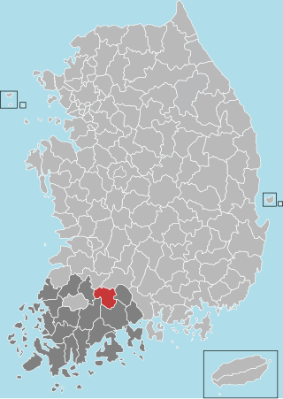
Buan County (Buan-gun) is a county in Jeonbuk Sate, South Korea. It is bounded by the city of Jeongeup on the east, the county of Gochang on the south, the city of Gimje on the north, and Yellow Sea on the west. Buan is divided into 1 eup, 12 myeon, and 510 ri. Buan had a 2001 estimated population of 74,716 people and a 2018 population of 54,441 people with an area of 493.35 km2. Famous people from Buan include Joseon Dynasty kisaeng and poet, Yi Mae-chang. Like many rural areas in southern Korea, it has seen shrinking population with many younger people moving north to larger cities such as Seoul. This county should not be confused with Muan, the new capital of South Jeolla Province.

<span class="mw-page-title-main">Seocheon County</span> County in Hoseo, South Korea

Seocheon County is a county in Chungcheongnam-do, South Korea. It is famous for its seafood and location near the mouth of the Geum River.

Namak-ri is a small town in Samhyang-myeon, which is part of Muan County in South Jeolla province of South Korea. Namak-ri became the home of the South Jeolla provincial government following its move from the city of Gwangju in 2005.

Korea Cement Co, Ltd. is a South Korean cement and chemical company, headquartered in Sinan-dong Buk-gu Gwangju, Korea. established in 1962. It is a manufacturer of cement products, and is under the Gangdong Group family. The CEO of Korea Cement is Lee Kuk No (이국노).

<span class="mw-page-title-main">Muan International Airport</span> International airport in Muan County, Jeollanam-do Province, South Korea

Muan International Airport is an airport in Muan County, Jeollanam-do, South Korea. Construction of the airport began in 1997 and the airport opened on November 9, 2007. The airport serves the province of Jeollanam-do, especially the cities of Gwangju, Mokpo and Naju. It replaced the nearby Mokpo Airport and is expected to replace the nearby Gwangju Airport in the near future as well. In 2018, 543,247 passengers used the airport. The airport is managed by the Korea Airports Corporation.

<span class="mw-page-title-main">Honam high-speed railway</span> Railway line in South Korea

The Honam high-speed railway, also known as Honam HSR, is a high-speed rail between Osong and Mokpo in South Korea. The line is a part of Korail's Korea Train Express (KTX) system, accelerating Seoul–Mokpo and Seoul–Gwangju KTX high-speed services which currently use the existing conventional Honam Line. On April 1, 2015, the line was inaugurated by the South Korean President Park Geun-hye with the attendance of 1200 invited guests and members of the public at Gwangju Songjeong Station in Gwangju, the line's terminus. The line diverges from Osong station on the Gyeongbu high-speed railway, and stops at Gongju, Iksan, Jeongeup Stations. Journey times between Seoul and Gwangju has been cut from 2 h 40 min to just 90 min, making daily commuting possible. The Honam HSR is intended to bring business, and economic opportunities to the province of Jeollanam-do, which has seen slower development than other parts of South Korea. The line has been open to the public since April 2, 2015 for revenue service.

<span class="mw-page-title-main">2015 Summer Universiade</span> Multi-sport event in Gwangju, South Korea

The 2015 Summer Universiade was a Universiade held in the city of Gwangju, South Korea. It took place from July 3 to July 14, 2015.

Daebul Industrial Complex is an industrial complex which covers a large portion of Samho, Yeongam of South Jeolla province in South Korea. The complex was initially designed to set up fundamental base for development in the Mokpo area. Finalized in December 1996, the residence of enterprises start from 1997. The complex was initially aimed at the south east Asia and China market.

Hadang (Korean: 하당신도시) is the newly built urban area in Mokpo, Jeollanam-do of South Korea, which aims at accommodating increased population near Muan International Airport and movement of the provincial office. Before announcement of the transfer of office, Mokpo city initially intended to rebuild another area for housing. The project was finalized so until 1999 most of area was leased for marketing, business, housing, and preliminary purpose.

<span class="mw-page-title-main">Changnyeong-eup</span> Town in Gyeongnam, South Korea

Changnyeong-eup is a town (eup) in the administrative county of Changnyeong, South Gyeongsang Province, in South Korea.

<span class="mw-page-title-main">Slavery on salt farms in Sinan County</span> 2014 human trafficking case in South Korea

Slavery on Sinan County's salt farms relates to the discovery of human trafficking cases in Sinan County (신안군), Jeollanam-do (전라남도), South Korea in 2014. It was discovered that individuals, mostly the homeless, were kidnapped and sent to salt farms to work without any compensation.

<span class="mw-page-title-main">Muan–Gwangju Expressway</span> Expressway in South Korea

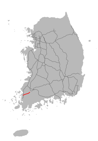
Muan–Gwangju Expressway also known as 12th Expressway is an expressway in South Korea connecting Muan County to Gwangju.

References

  1. Welcome to muan-gun Archived 2007-09-28 at the Wayback Machine
  2. Alteration of the districts of boundaries including cities and counties(1962.11.21.)
  3. Regulation concerning establishment of 35 eup(towns). (1980. 10. 21.)
  4. Official page
  5. 무안기업도시 한중국제산단 민간자본금 증액 ‘개발 탄력’. 11 January 2008. Retrieved 9 April 2018.
  6. 꼼지락대는 생명을 잉태한 청정 갯벌, 무안갯벌. korean.visitkorea.or.kr (in Korean). Retrieved 2018-06-06.
  7. Muan White Lotus Festival (무안연꽃축제) - Official Korea Tourism Organization. english.visitkorea.or.kr.
  8. Hoesan White Lotus Pond in Muan (무안회산백련지) - Official Korea Tourism Organization. english.visitkorea.or.kr.
  9. Official page of Muan
  10. "Climatological Normals of Korea (1991 ~ 2020)" (PDF) (in Korean). Korea Meteorological Administration. Archived from the original (PDF) on 29 January 2022. Retrieved 7 June 2023.
  11. "International Exchange". List of Affiliation Partners within Prefectures. Council of Local Authorities for International Relations (CLAIR). Archived from the original on 24 December 2015. Retrieved 21 November 2015.
  12. "Denizli Metropolitan Municipality - Official Website". eng.denizli.bel.tr.

34°59′23″N126°28′17″E / 34.98972°N 126.47139°E / 34.98972; 126.47139