Jeongeup

Last updated • 2 min readFrom Wikipedia, The Free Encyclopedia

Jeongeup
정읍시
Korean transcription(s)
   Hangul 정읍시
   Hanja 井邑市
  Revised RomanizationJeongeup-si
  McCune–ReischauerChŏngŭp-si
Naejangsan Pavilion 2.jpg
Jeongeup seen from Seonghwangsan - 2009-02-04.JPG
From the top: Naejangsan, Jeongeup seen from Seonghwangsan
Flag of Jeongeup.svg
Jeongeup logo.png
North Jeolla-Jeongeup.svg
Location in South Korea
Coordinates: 35°34′N126°51′E / 35.567°N 126.850°E / 35.567; 126.850
Country South Korea
Region Honam
Province North Jeolla
Administrative divisions 1 eup, 14 myeon, 12 dong
Area
  Total
692.66 km2 (267.44 sq mi)
Population
 (March, 2022)
  Total
106,187
  Density153/km2 (400/sq mi)
  Dialect
Jeolla

Jeongeup (Korean : 정읍; Korean pronunciation: [tɕʌŋ.ɯp̚] ), is a city in North Jeolla Province, South Korea. The city limits include Naejang-san National Park, a popular destination particularly in autumn due to its foliage. Jeongeup is on the Honam Expressway and Honam Line, with the Seohaean Expressway also within easy reach, providing links to Seoul and Mokpo.

Contents

Demographics

Jeongeup's population is in decline, with an average of 56 people moving to the city every day but 91 leaving, with the birth and death rates being equal. The divorce rate currently runs at 50%. [1]

Geography

Namchang Valley, Naejangsan naejangsan namcanggyegog.jpg
Namchang Valley, Naejangsan

The main hills in Jeongeup are Naejang-san National Park and Ibamsan, though there are also several smaller hills in the city. It is the east of the city which is more mountainous, the west being a plain around the Dongjin River. There are several streams in Jeongeup, most notably the Jeongeupcheon, a tributary of the Dongjin. This over went a makeover by the city council in December 2009.

Attractions

Jeongeup, like many cities in Korea, had a hyanggyo, or Confucian school, where people were trained in Confucian ways. This building is a tourist attraction today, but is not open to the public.

Jeongeup is known for a traditional song from the Baekje Kingdom era, known as Jeongeup-ga. The song tells the tale of the lamenting heart of a woman waiting for her peddler husband's return.

Naejangsa Temple: first erected in 636, but most of its current buildings were built after the Japanese invasions of Korea in 1597 and the Korean War. [2] On 31 October 2012, the temple was destroyed in a fire that broke out. [3]

Festivals

A maple festival around Naejang-san is held annually. The maple leaves here are widely regarded as some of the most beautiful in the country. The festival was abolished in 2002 but was revived in 2007. [4] [ full citation needed ] This festival includes several events regarding the chrysanthemum love.

Additionally, a century ago, Jeongeup was the site of a revolution by the religious movement of Cheondoism. A lot of peasants joined the movement against the Japanese invaders. For this, Jeongeup holds an annual ceremony to commemorate the event. [5]

Industry

Major companies in Jeongeup include Cargill Agri-Purina, Twosome Place, SK Nexilis, Ewon Comfort, DSpeed, Harim, Dongwon F&B, K-Net, Palmsco, and Shinheung. [6]

Notable people

Twin towns – sister cities

Jeongeup is twinned with:

Climate

Jeongeup has a cooler version of a humid subtropical climate (Köppen climate classification Cfa).

Climate data for Jeongeup (1991–2020 normals, extremes 1970–present)
MonthJanFebMarAprMayJunJulAugSepOctNovDecYear
Record high °C (°F)18.5
(65.3)
21.7
(71.1)
27.3
(81.1)
31.0
(87.8)
34.1
(93.4)
34.2
(93.6)
37.3
(99.1)
38.4
(101.1)
37.3
(99.1)
30.7
(87.3)
27.6
(81.7)
19.6
(67.3)
38.4
(101.1)
Mean daily maximum °C (°F)4.5
(40.1)
7.1
(44.8)
12.7
(54.9)
19.3
(66.7)
24.5
(76.1)
27.9
(82.2)
30.3
(86.5)
31.1
(88.0)
26.9
(80.4)
21.3
(70.3)
14.2
(57.6)
6.9
(44.4)
18.9
(66.0)
Daily mean °C (°F)−0.2
(31.6)
1.7
(35.1)
6.4
(43.5)
12.4
(54.3)
18.0
(64.4)
22.2
(72.0)
25.7
(78.3)
26.1
(79.0)
21.4
(70.5)
15.1
(59.2)
8.6
(47.5)
2.1
(35.8)
13.3
(55.9)
Mean daily minimum °C (°F)−4.4
(24.1)
−2.9
(26.8)
1.0
(33.8)
6.4
(43.5)
12.2
(54.0)
17.5
(63.5)
22.2
(72.0)
22.3
(72.1)
16.9
(62.4)
9.8
(49.6)
3.7
(38.7)
−2.2
(28.0)
8.5
(47.3)
Record low °C (°F)−19.8
(−3.6)
−20.0
(−4.0)
−10.9
(12.4)
−4.2
(24.4)
2.4
(36.3)
8.5
(47.3)
13.1
(55.6)
11.6
(52.9)
5.6
(42.1)
−1.5
(29.3)
−10.4
(13.3)
−15.2
(4.6)
−20.0
(−4.0)
Average precipitation mm (inches)36.5
(1.44)
39.0
(1.54)
56.0
(2.20)
82.5
(3.25)
87.2
(3.43)
136.1
(5.36)
284.0
(11.18)
298.1
(11.74)
148.5
(5.85)
61.0
(2.40)
55.6
(2.19)
45.3
(1.78)
1,329.8
(52.35)
Average precipitation days (≥ 0.1 mm)9.97.68.68.38.89.514.314.49.16.68.510.9116.5
Average snowy days9.46.02.50.10.00.00.00.00.00.02.27.127.4
Average relative humidity (%)73.267.964.261.563.870.977.176.675.071.771.573.170.5
Mean monthly sunshine hours 138.2159.0197.0215.3227.3176.1152.9168.9179.9190.6151.4131.42,088
Percent possible sunshine 47.852.452.857.454.244.439.446.851.358.950.846.550.1
Source: Korea Meteorological Administration (snow and percent sunshine 1981–2010) [7] [8] [9]

See also

Related Research Articles

<span class="mw-page-title-main">Gwangju</span> City in South Korea

Gwangju, formerly romanized as Kwangju, is South Korea's sixth-largest metropolis. It is a designated metropolitan city under the direct control of the central government's Home Minister. The city was also the capital of South Jeolla Province until the provincial office moved to the southern village of Namak in Muan County in 2005 because Gwangju was promoted to a metropolitan city and was independent of South Jeolla Province.

<span class="mw-page-title-main">Gunsan</span> City in North Jeolla, South Korea

Gunsan, also romanized as Kunsan, is a city in Jeonbuk State, South Korea. It is on the south bank of the Geum River just upstream from its exit into the Yellow Sea. It has emerged as a high-tech manufacturing industrial city and an international trade seaport that is approximately 200 km (120 mi) southwest of Seoul on the midwest coast of the Korean Peninsula.

<span class="mw-page-title-main">Honam Line</span> Railway line in South Korea

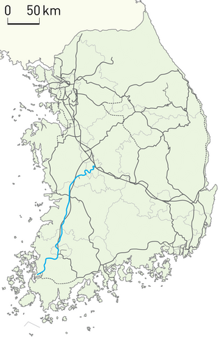
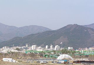
The Honam Line is a major railway line serving the Honam region in South Korea. The line is served by frequent passenger trains from Seoul to Gwangju and Mokpo.

<span class="mw-page-title-main">Buyeo County</span> County in Hoseo, South Korea

Buyeo County (Buyeo-gun) is a county in South Chungcheong Province, South Korea. Buyeo-eup, the county's capital, was the site of the capital of Baekje from 538-660 AD, during which it was called Sabi Fortress.

<span class="mw-page-title-main">Yeongju</span> City in North Gyeongsang, South Korea

Yeongju is a city in North Gyeongsang Province, South Korea. It has an area of 668.84 km2 and a population of 113,930 people according to the 2008 census. The city borders Bonghwa county to the east, Danyang County of North Chungcheong Province to the west, Andong and Yecheon county to the south, and Yeongwol County of Gangwon Province to the north.

<span class="mw-page-title-main">Yeongcheon</span> City in North Gyeongsang, South Korea

Yeongcheon is a city in North Gyeongsang Province, South Korea.

<span class="mw-page-title-main">Donghae, Gangwon</span> City in Gangwon, South Korea

Donghae is a city in Gangwon Province, South Korea. There are two major ports: Donghae Harbor and Mukho Harbor. The city is located on the Yeongdong Line railroad and the Donghae Expressway. Numerous caverns are found in the city, as in neighboring Samcheok. Hanzhong University was located here.

<span class="mw-page-title-main">Pyeongchang County</span> County in Gangwon-do, South Korea

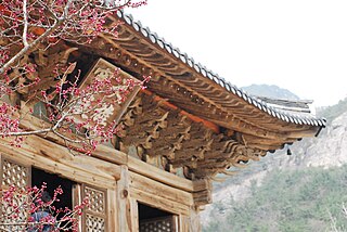
Pyeongchang is a county in the province of Gangwon-do, South Korea, located in the Taebaek Mountains region. It is home to several Buddhist temples, including Woljeongsa. It is about 180 km (110 mi) east southeast of Seoul, the capital of South Korea, and connected by expressways and high-speed passenger railways. Pyeongchang's slogan, "Happy 700 Pyeongchang", is taken from its average elevation of approximately 700 metres (2,300 ft).

<span class="mw-page-title-main">Buan County</span> County in Honam, South Korea

Buan County is a county in Jeonbuk State, South Korea. It is bounded by the city of Jeongeup on the east, the county of Gochang on the south, the city of Gimje on the north, and Yellow Sea on the west. Buan is divided into 1 eup, 12 myeon, and 510 ri. Buan had a 2001 estimated population of 74,716 people and a 2018 population of 54,441 people with an area of 493.35 km2. Famous people from Buan include Joseon Dynasty kisaeng and poet, Yi Mae-chang. Like many rural areas in southern Korea, it has seen shrinking population with many younger people moving north to larger cities such as Seoul. This county should not be confused with Muan, the new capital of South Jeolla Province.

<span class="mw-page-title-main">Chuncheon</span> City in Gangwon, South Korea

Chuncheon, formerly romanized as Ch'unch'ŏn, is the capital of Gangwon Province, South Korea. The city lies in the north of the country, located in a basin formed by the Soyang River and Han River. There are some large lakes around the city, most notably Soyang Lake and Uiam Lake. The area has small river islands, such as Sangjungdo, Ha-Jungdo, Bungeodo, and Wido.

<span class="mw-page-title-main">Sokcho</span> City in Gangwon, South Korea

Sokcho is a city and major tourist hub located in the northeast of Gangwon Province, South Korea.

<span class="mw-page-title-main">Jeju City</span> City in Jeju, South Korea

Jeju City is the capital of the Jeju Province in South Korea and the largest city on Jeju Island. The city is served by Jeju International Airport.

<span class="mw-page-title-main">Dongducheon</span> City in Gyeonggi, South Korea

Dongducheon is a city in Gyeonggi Province, South Korea.

<span class="mw-page-title-main">Icheon</span> City in Gyeonggi, South Korea

Icheon is a city in Gyeonggi Province, South Korea.

<span class="mw-page-title-main">Namyangju</span> City in Gyeonggi, South Korea

Namyangju is a city in Gyeonggi Province, South Korea. To the east is Gapyeong County, to the west is Guri, and to the north is Pocheon. Namyangju was originally a southern part of Yangju-gun, but was separated into Namyangju-gun in April 1980. In 1995, Migeum-si and Namyangju-gun were merged to form an urban and rural complex. The city hall is located in Geumgok-dong and Dasan-dong, and the administrative districts are 6-eup, 3-myeon, and 7-dong.

<span class="mw-page-title-main">Cheonan</span> City in South Chungcheong, South Korea

Cheonan is the largest and most densely populated city of South Chungcheong Province, South Korea, and the third largest city in the Hoseo region after Daejeon and Cheongju. Cheonan borders Gyeonggi Province in the north, North Chungcheong Province to the east and southeast, Sejong to the south and Asan and Gongju to the west and southwest.

<span class="mw-page-title-main">Seosan</span> City in South Chungcheong, South Korea

Seosan is a city in South Chungcheong Province, South Korea, with a population of roughly 175,000 according to the 2017 census. Located at the northwestern end of South Chungcheong Province, it is bounded by Dangjin, Naepo New Town, Yesan-gun and Hongseong-gun on the east, Taean-gun and the Yellow Sea on the west, 125 km (78 mi) south of Seoul, 159 km (99 mi) northwest of Daejeon and 34 km (21 mi) northwest of Naepo New Town. Seosan is the hub of transportation on the west coast where the Seohaean Expressway, Daejeon-Dangjin Expressway, and National Highways No. 29, 32, 38, and 45 intersect.

<span class="mw-page-title-main">Miryang</span> City in South Gyeongsang, South Korea

Miryang (Korean: 밀양) is a city in South Gyeongsang Province, South Korea. Neighboring cities include Changnyeong to the west, Cheongdo to the north, Ulsan to the east, and Yangsan, Gimhae, and Changwon to the south. The city bird is the Korean magpie, the city tree is the pine, and the city flower is the royal azalea.

<span class="mw-page-title-main">Yangsan</span> City in South Gyeongsang, South Korea

Yangsan is a city in Gyeongsangnam-do Province, South Korea.

<span class="mw-page-title-main">Tourism in South Korea</span>

Tourism in South Korea and its industry caters to both foreign and domestic tourists. In 2023, 11.0 million foreign tourists visited South Korea, making it the 20th most visited country in the world. Most non-Korean tourists come from East Asia and North America, such as Taiwan and the United States. The popularity of Korean popular culture, often known as the "Korean Wave", in countries around the world has significantly increased tourist arrivals.

References

  1. 녹두꽃피고 파랑새나는 정읍 만들기. Jeongeup City Council. Archived from the original on 15 February 2005. Retrieved 5 February 2009.
  2. Cin, Woo Lee (10 February 2012). "Simply stunning: 33 incredible Korean temples". CNN Travel. Archived from the original on 5 July 2013. Retrieved 12 April 2012.
  3. "Temple lost to fire". The Hankyoreh . 1 November 2012. Archived from the original on 21 April 2013. Retrieved 25 February 2013.
  4. [Wonderful maple of Naejang mountain] 내장산 단풍… 마냥 고와서 문득 서러워라 국민일보2007.11.01
  5. ""Welcome to honam Udo nongak"". Archived from the original on 10 January 2005. Retrieved 26 January 2008.
  6. "정읍시 주요 기업 리스트 요약". informative.kr. Retrieved 7 January 2025.
  7. "Climatological Normals of Korea (1991 ~ 2020)" (PDF) (in Korean). Korea Meteorological Administration. Archived from the original (PDF) on 29 January 2022. Retrieved 4 April 2022.
  8. 순위값 – 구역별조회 (in Korean). Korea Meteorological Administration. Archived from the original on 7 October 2021. Retrieved 4 April 2022.
  9. "Climatological Normals of Korea" (PDF). Korea Meteorological Administration. 2011. Archived from the original (PDF) on 7 December 2016. Retrieved 8 December 2016.