Sacheon

Last updated • 3 min readFrom Wikipedia, The Free Encyclopedia
Sacheon
사천시
Korean transcription(s)
   Hangul 사천시
   Hanja
  Revised RomanizationSacheon-si
  McCune-ReischauerSach'ŏn-si
Changsun Sachunpo Bridge2.JPG
Flag of Sacheon.svg
Sacheon logo.png
South Gyeongsang-Sacheon.svg
Location in South Korea
CountryFlag of South Korea.svg  South Korea
Region Yeongnam
Administrative divisions 1 eup, 7 myeon, 6 dong
Area
  Total396.99 km2 (153.28 sq mi)
Population
  Total114,556
  Density288.6/km2 (747/sq mi)
  Dialect
Gyeongsang

Sacheon (Korean : 사천; Korean pronunciation: [sʰa.tɕʰʌn] ) is a city in South Gyeongsang Province, South Korea. Sacheon's chief fame comes from its being the site of two naval battles in the Seven Year War.

Contents

The city as it now exists results from the merging of Sacheon-gun and Samcheonpo-si in 1995. The northern part of the city is called Sacheon-eub and is located at the top of Sacheon Bay, near the city of Jinju. The southern part of the city is located in the old Samcheonpo-si, which is located at the mouth of Sacheon Bay.

History

During prehistoric times, the local area was very important for trade between the interior and coastal area. A large central settlement called the Igeum-dong site developed in the neighbourhood of the same name in Samcheonpo. This complex site was a major settlement, megalithic cemetery, and ceremonial area during the latter part of the Middle Mumun pottery period (c. 700-550 B.C.). Several islands that lie just off the coast of Samcheonpo, including Neuk-do Island and Ma-do Islet, were also important during the same period and into the Korean Protohistoric period when this part of Korea increased its trade contacts with the chiefdoms in the Liaoning Province region of China, Taedong-gang River area of North Korea, and Yayoi chiefdoms of Western Japan (c. 300 B.C.- A.D. 300/400).

Economy

Traditionally, the urbanized part of Sacheon (Sacheon-eub) and the coastal settlement of Samcheonpo have different economic functions. Samcheonpo has a good harbour and has been sustained by fishing and other marine industries for hundreds of years. This part of the city continues to be a regional hub for these industries: A major fish market and a number of live fish distribution centres are located at the harbour area. Sacheon-eub is in close proximity to the Namhae Expressway and the city of Jinju, thus contains manufacturing, transport and service industry facilities.

Korean Aerospace Industries, a national South Korean aerospace company, is based in Sacheon. British American Tobacco Korea has a major manufacturing complex in Sacheon, too.

Much of the area between Sacheon-eub and Samcheonpo is a narrow coastal plain, and devoted to fruit producing orchards as well as wet and dry agriculture.

Transportation

Sacheon Airport is located in the industrial part of Sacheon-eup, and there are two daily flights to Seoul's Gimpo airport. The Korean National Railroad passenger terminal is located in nearby Jinju. Sacheon-eup and Samcheonpo both have bus terminals that serve local and regional destinations such as Jinju, Masan, and Busan.

Attractions

The harbour area of Samcheonpo contains a multitude of rustic but popular raw fish restaurants close to the waterfront. The fish and traditional market areas are nearby.

The harbour of Samcheonpo is the gateway to a number of small islands lying offshore, where people still practice a traditional fishing subsistence lifestyle that dates back to the Jeulmun Period (c. 4000 BC).

Climate

Climate data for Samcheonpo, Sacheon (1993–2020 normals)
MonthJanFebMarAprMayJunJulAugSepOctNovDecYear
Mean daily maximum °C (°F)6.8
(44.2)
8.9
(48.0)
12.9
(55.2)
17.9
(64.2)
22.4
(72.3)
25.2
(77.4)
28.2
(82.8)
30.1
(86.2)
27.0
(80.6)
22.2
(72.0)
15.6
(60.1)
9.1
(48.4)
18.9
(66.0)
Daily mean °C (°F)2.7
(36.9)
4.5
(40.1)
8.5
(47.3)
13.5
(56.3)
18.1
(64.6)
21.4
(70.5)
24.8
(76.6)
26.4
(79.5)
22.9
(73.2)
17.6
(63.7)
11.3
(52.3)
4.9
(40.8)
14.7
(58.5)
Mean daily minimum °C (°F)−1.0
(30.2)
0.6
(33.1)
4.6
(40.3)
9.7
(49.5)
14.7
(58.5)
18.8
(65.8)
22.5
(72.5)
23.7
(74.7)
19.7
(67.5)
13.7
(56.7)
7.1
(44.8)
1.0
(33.8)
11.3
(52.3)
Average precipitation mm (inches)25.6
(1.01)
44.7
(1.76)
76.4
(3.01)
122.1
(4.81)
139.1
(5.48)
186.3
(7.33)
295.0
(11.61)
237.4
(9.35)
171.5
(6.75)
77.4
(3.05)
45.9
(1.81)
24.9
(0.98)
1,446.3
(56.94)
Average precipitation days (≥ 0.1 mm)3.54.06.57.88.09.111.810.27.54.34.63.480.7
Source: Korea Meteorological Administration [1]

Twin towns – sister cities

Sacheon is twinned with:

Trivia

In Korean, the idiom "잘 나가다가 삼천포로 빠진다", literally "Was going well but suddenly slips into Samcheonpo," means that a speaker has gone off-topic. [2]

Park Seonghwa, member of the K-pop group ATEEZ, was born in Sacheon, but was raised in Jinju. [3]

See also

Related Research Articles

<span class="mw-page-title-main">South Gyeongsang Province</span> Province of South Korea

South Gyeongsang Province is a province in the southeast of South Korea. The provincial capital is at Changwon. It is adjacent to the major metropolitan center and port of Busan. The UNESCO World Heritage Site Haeinsa, a Buddhist temple that houses the Tripitaka Koreana and tourist attraction, is located in this province. Automobile and petrochemical factories are largely concentrated along the southern part of the province, extending from Ulsan through Busan, Changwon, and Jinju.

<span class="mw-page-title-main">Pohang</span> Specific city in Yeongnam, South Korea

Pohang, formerly spelled Po-Hang, is the largest city in North Gyeongsang Province, South Korea, with a population of 499,363 as of 2022, bordering the Sea of Japan to the east, Yeongcheon to the west, Gyeongju to the south, and Cheongsong and Yeongdeok to the north.

<span class="mw-page-title-main">Gyeongju</span> Municipal City in North Gyeongsang Province, South Korea

Gyeongju, historically known as Seorabeol, is a coastal city in the far southeastern corner of North Gyeongsang Province, South Korea. It is the second largest city by area in the province after Andong, covering 1,324 km2 (511 sq mi) with a population of 264,091 people as of December 2012. Gyeongju is 370 km (230 mi) southeast of Seoul, and 55 km (34 mi) east of Daegu. The city borders Cheongdo and Yeongcheon to the west, Ulsan to the south and Pohang to the north, while to the east lies the coast of the Sea of Japan. Numerous low mountains—outliers of the Taebaek range—are scattered around the city.

<span class="mw-page-title-main">Mungyeong</span> Municipal City in Yeongnam, South Korea

Mungyeong is a city in North Gyeongsang Province, South Korea. The local government, economy, and transportation networks are all centered in Jeomchon, the principal town. Mungyeong has a lengthy history, and is known today for its various historic and scenic tourist attractions. The city's name means roughly "hearing good news." Recently, development has been somewhat stagnant with the decline of the coal industry. Since the 1990s, the proportion of people who rely on the tourism industry through Mungyeong Saejae has gradually increased.

<span class="mw-page-title-main">Sangju</span> Municipal City in Yeongnam, South Korea

Sangju is a city in North Gyeongsang Province, central South Korea. Although Sangju is rather rural, it is very old and was once a key city. Along with Gyeongju, it gives rise to half of the name of the Gyeongsang provinces. Sangju is nicknamed Sam Baek, or "Three Whites", referring to three prominent agricultural products rice, silkworm cocoons, and dried persimmons from the area.

<span class="mw-page-title-main">Jinju</span> Municipal City in Yeongnam, South Korea

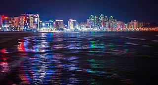
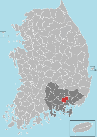
Jinju is a city in South Gyeongsang Province, South Korea. It was the location of the first (1592) and second (1593) Sieges of Jinju by Japanese forces during the Imjin War. The Republic of Korea Air Force Education and Training Command is located in the eastern part of the city. There are cultural-historical tourist attractions in Jinju such as Jinju Fortress, the Jinju National Museum, and the Nam-gang Prehistoric Site Museum.

<span class="mw-page-title-main">Goseong County, South Gyeongsang</span> County in Yeongnam, South Korea

Goseong County (Goseong-gun) is a county in South Gyeongsang Province, South Korea

<span class="mw-page-title-main">Haman County</span> County in Yeongnam, South Korea

Haman County (Haman-gun) is a county in South Gyeongsang Province, South Korea. The local government is seated in the town of Gaya-eup. The county magistrate is Seok Gyu Jin.

<span class="mw-page-title-main">Uiryeong County</span> County in Yeongnam, South Korea

Uiryeong County is a county in South Gyeongsang Province, South Korea.

<span class="mw-page-title-main">Mumun pottery period</span> Korean historical period

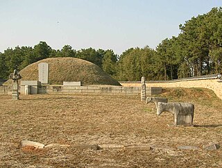
The Mumun pottery period is an archaeological era in Korean prehistory that dates to approximately 1500-300 BC. This period is named after the Korean name for undecorated or plain cooking and storage vessels that form a large part of the pottery assemblage over the entire length of the period, but especially 850-550 BC.

<span class="mw-page-title-main">Jinyang Lake</span> Reservoir in South Gyeongsang Province

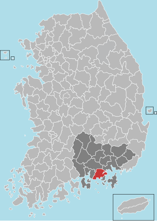
Jinyang Lake (Korean: 진양호) is a reservoir covering portions of Jinju and Sacheon, South Gyeongsang Province, South Korea. The water surface covers 29.4 km². It was formed in 1970, by the construction of a dam where the Gyeongho and Deokcheon rivers join to form the Nam River.

Gaeun (Korean: 가은) is an eup in Mungyeong, Gyeongsangbuk-do, South Korea. It was formerly a center of coal-mining, but the last mines closed in the 1990s. The dominant local industries are now tourism and agriculture. There are also several operating kilns.

<span class="mw-page-title-main">Igeum-dong</span>

Igeum-dong is a complex archaeological site located in Igeum-dong, Samcheonpo in Sacheon-si, South Gyeongsang Province, South Korea. This prehistoric archaeological site is important in Korean prehistory because it represents solid evidence that simple chiefdoms formed in as early as the Middle Mumun, some 950 years before the first state-level societies formed in Korea. The settlement is dated by pottery, pit-house types, and an AMS radiocarbon date to the Late Middle Mumun Pottery Period. Test excavations were conducted in 1997, and wide-scope horizontal excavations took place in 1998 and 1999.

<span class="mw-page-title-main">Daepyeong</span> Archaeological site in South Gyeongsang Province, South Korea

Daepyeong is a complex prehistoric archaeological site located in the Nam River valley near Jinju in South Gyeongsang Province, South Korea. Pottery typologies and seriations and a host of AMS radiocarbon dates show that the site had a number of occupations over several millennia from c. 3500 BC - AD 500.

<span class="mw-page-title-main">Yoshinogari site</span>

Yoshinogari is the name of a large and complex Yayoi archaeological site in Yoshinogari and Kanzaki in Saga Prefecture, Kyūshū, Japan. According to the Yayoi chronology established by pottery seriations in the 20th century, Yoshinogari dates to between the 3rd century BC and the 3rd century AD. However, recent attempts to use absolute dating methods such as AMS radiocarbon dating have shown that the earliest Yayoi component of Yoshinogari dates to before 400 BC.

<span class="mw-page-title-main">Sacheon Airport</span> Airport in Sacheon, South Korea

Sacheon Airport is an airport in Sacheon, South Gyeongsang Province, South Korea. It also serves the city of Jinju. The airport passenger service began in 1977 after years of delays. The airport has a small single storey terminal building for domestic flights. In 2011, 143,483 passengers utilized the airport. Because Sacehon Airport is sharing with military, taking photograph or video of apron, runway and military facility is strictly prohibited.

<span class="mw-page-title-main">Gwangpo Bay</span> Bay in Sacheon, South Korea

Gwangpo Bay (Korean: 광포만) is located in Sacheon, South Gyeongsang Province, South Korea. The bay is located at the estuary of Gonyang Stream, and the city is located in the middle of the southern seashore of South Korea. Gwangpo Bay is a part of larger Sacheon Bay, which is surrounded by Sacheon City, Gwangyang City, and Namhae County.

<span class="mw-page-title-main">Changnyeong-eup</span> Town in Gyeongnam, South Korea

Changnyeong-eup is a town (eup) in the administrative county of Changnyeong, South Gyeongsang Province, in South Korea.

<span class="mw-page-title-main">Busan–Gyeongnam Area</span> Metropolitan area in *Busan *Ulsan *Changwon *Yangsan *Gimhae, South Korea

Busan–Gyeongnam Area, also known as Pusan–Kyŏngnam (PK) is the metropolitan area of Busan, Ulsan, and Gyeongsangnam-do (Gyeongnam) located in southeast South Korea.

References

  1. "Climatological Normals of Korea (1991 ~ 2020)" (PDF) (in Korean). Korea Meteorological Administration. Archived from the original (PDF) on 29 January 2022. Retrieved 7 June 2023.
  2. "잘 나가다가 삼천포로 빠진다 유래". 잘 나가다가 삼천포로 빠진다 유래. Retrieved 27 January 2022.
  3. "SEONGHWA (ATEEZ) Profile, Facts & Favorites - karchives". KArchives. Retrieved 1 November 2022.

35°04′N128°05′E / 35.067°N 128.083°E / 35.067; 128.083