Hamyang County

Last updated
Hamyang
함양군
Korean transcription(s)
  Hangul함양군
  Hanja
  Revised RomanizationHamyang-gun
  McCune-ReischauerHamyang-gun
Flag of Hamyang.svg
Hamyang logo.png
South Gyeongsang-Hamyang.svg
Location in South Korea
CountryFlag of South Korea.svg  South Korea
Region Yeongnam
Administrative divisions 1 eup, 10 myeon
Area
  Total725.03 km2 (279.94 sq mi)
Population
 (2014)
  Total40,692
  Density56.1/km2 (145/sq mi)
  Dialect
Gyeongsang

Hamyang County (Hamyang-gun) is a county in South Gyeongsang Province, South Korea.

Contents

It is home to the Wooden Seated Statue of Buddha in Beopinsa (법인사), the Standing Statue of Buddha in Deokjeonri (덕전리), the Three-Level Stone Pagoda, Stone Seated Statue of Buddha, Three Storied Stone Pagoda of Seungansa (승안사) Temple Site. There are also historical sites such as the Namgyeseowon (남계서원) Confucian School, Hwangseoksanseong (황석산성) Fortress, and Sageunsanseong (사근산성) Fortress. [1]

History

Three Kingdoms Period

The Sageunsanseong Fortress, which encircles the peak of Yeonhwasan Mountain (443 m above sea level) is presumed to have been built during the Three Kingdoms of Korea (57 BCE-668 CE) and used until the Joseon period (1392-1910). The fortress was located at a strategic pass and was therefore a site of fierce conflicts between the Baekje Kingdom (18 BCE-660 CE) to the west and the Silla Kingdom (57 BCE-935 CE) to the east. The fortress also played a very important role in guarding against Japanese pirates who invaded from the southern coast in an attempt to reach the fertile lands of the Jeolla region. [2]

According to historical sources, it is said that when the Japanese invaded this area in 1380, around 500 people died here in battle. The fortress was neglected for centuries until it was repaired in the late 15th century. [2]

The fortress wall measures about 1.2 km in circumference and about 5 m in height. The walls are made of rectangular stones and were built using a technique typical of the 7th century. Inside the fortress, various remains were excavated, including building and gate sites and a stone pond, as well as artifacts from the Baekje and Silla Kingdoms. [2]

The Unified Shilla period

Hamyang-gun was called Sokham-gun or Hamsung during the Unified Shilla era. In 757 AD in the 16th year of King Gyeongdeok of Silla, the name was changed to Cheonryung-gun. Under King Gyeongduk's reign, it was called Yeosun and placed under Geochang-gun. [1]

Joseon Dynasty

In 1552, the Namgyeseowon Confucian Academy was built during the 7th year of the reign of Myeongjong of Joseon) in memory of Jeong Yeo-chang's academic accomplishments. [3]

In mid-August 1597, in the early stage of the Jeongyujae crisis, there was an invasion of Japanese troops against the Hwangseoksan Fortress. The battle was fought between local citizens in Hamyang and Aneum Geochang of Joseon and Katō Kiyomasa of the Japanese military, with over 60,000 troops. The Hwangseoksanseong Fortress was guarded by Gwak Jun, the governor of Aneumhyeon, as the chief commander, Baek Sa-rim of Gimhae Busa as the supreme commander, and Jo Jo-do, the former governor of Hamyang. The battle started on August 16 and the Joseon army was completely annihilated on the 18th, but Baeksarim of Gimhae Bussa. 353 Koreans were killed inside the fortress. [4]

Climate

Climate data for Hamyang (2011–2020 normals, extremes 2010–present)
MonthJanFebMarAprMayJunJulAugSepOctNovDecYear
Record high °C (°F)17.3
(63.1)
23.0
(73.4)
26.5
(79.7)
30.9
(87.6)
35.1
(95.2)
36.7
(98.1)
37.8
(100.0)
37.3
(99.1)
34.0
(93.2)
31.2
(88.2)
26.2
(79.2)
17.3
(63.1)
37.8
(100.0)
Mean daily maximum °C (°F)5.8
(42.4)
8.4
(47.1)
14.3
(57.7)
19.7
(67.5)
25.5
(77.9)
28.2
(82.8)
30.4
(86.7)
31.2
(88.2)
26.3
(79.3)
21.6
(70.9)
15.0
(59.0)
7.4
(45.3)
19.5
(67.1)
Daily mean °C (°F)−0.3
(31.5)
1.8
(35.2)
7.0
(44.6)
12.4
(54.3)
18.0
(64.4)
22.0
(71.6)
25.2
(77.4)
25.4
(77.7)
19.9
(67.8)
13.6
(56.5)
7.8
(46.0)
1.2
(34.2)
12.8
(55.0)
Mean daily minimum °C (°F)−5.7
(21.7)
−4.2
(24.4)
−0.1
(31.8)
5.1
(41.2)
10.5
(50.9)
16.6
(61.9)
21.1
(70.0)
21.3
(70.3)
15.0
(59.0)
7.6
(45.7)
1.9
(35.4)
−4.1
(24.6)
7.1
(44.8)
Record low °C (°F)−16.0
(3.2)
−14.3
(6.3)
−8.3
(17.1)
−4.3
(24.3)
0.8
(33.4)
8.1
(46.6)
12.5
(54.5)
11.6
(52.9)
4.6
(40.3)
−3.6
(25.5)
−6.5
(20.3)
−14.0
(6.8)
−16.0
(3.2)
Average precipitation mm (inches)22.8
(0.90)
30.5
(1.20)
60.5
(2.38)
104.7
(4.12)
64.4
(2.54)
114.0
(4.49)
285.1
(11.22)
289.1
(11.38)
165.1
(6.50)
115.6
(4.55)
50.9
(2.00)
22.4
(0.88)
1,325.1
(52.17)
Average precipitation days (≥ 0.1 mm)5.96.18.29.98.711.115.414.410.87.08.67.6113.7
Average relative humidity (%)64.062.061.864.768.677.384.684.985.180.374.968.773.1
Mean monthly sunshine hours 179.7174.1226.1207.0249.2178.7147.4165.2150.2184.2149.7163.92,175.4
Source: Korea Meteorological Administration [5] [6]

Symbol

Twin towns – sister cities

Hamyang is twinned with:

See also

Related Research Articles

Korea's provinces have been the primary administrative division of Korea since the mid Goryeo (Koryo) dynasty in the early 11th century, and were preceded by provincial-level divisions dating back to Unified Silla and Balhae during the Northern and Southern States period, in the 7th century.

<span class="mw-page-title-main">North Jeolla Province</span> Province of South Korea

Jeonbuk State, also known as Jeonbuk is a Special Self-governing Province of South Korea in the Honam region in the southwest of the Korean Peninsula. Jeonbuk borders the provinces of South Chungcheong to the north, North Gyeongsang and South Gyeongsang to the east and South Jeolla to the south.

<span class="mw-page-title-main">Jeolla Province</span> Historical province of Korea

Jeolla Province was one of the historical Eight Provinces of Korea during the Kingdom of Joseon in southwestern Korea. It consisted of the modern South Korean provinces of North Jeolla, South Jeolla and Gwangju Metropolitan City as well as Jeju Province. The provincial capital was Jeonju, the current capital of North Jeolla. The entire inland region was called Honam, which is still commonly used today.

<span class="mw-page-title-main">Jeonju</span> City in North Jeolla, South Korea

Jeonju is the capital and largest city of North Jeolla Province, South Korea. It is both urban and rural due to the closeness of Wanju County which almost entirely surrounds Jeonju. It is an important tourist center famous for Korean food, historic buildings, sports activities, and innovative festivals.

<span class="mw-page-title-main">Gyeongsang Province</span> Historical province of Korea

Gyeongsang was one of the Eight Provinces of Joseon Korea. Gyeongsang was located in southeastern Korea.

Kim is the most common surname in Korea. As of the 2015 South Korean census, there were 10,689,959 people by this name in South Korea or 21.5% of the population. Although the surname is always pronounced the same, dozens of different family clans use it. The clan system in Korea is unique from the surname systems of other countries. Kim is written as 김 in both North and South Korea. The hanja for Kim, , can also be transliterated as 금 which means 'gold, metal, iron'. While romanized as Kim by 99.3% of the population, other rare variant romanizations such as Gim, Ghim, and Kin consist of the remaining 0.6%.

<span class="mw-page-title-main">Gochang County</span> County in Honam, South Korea

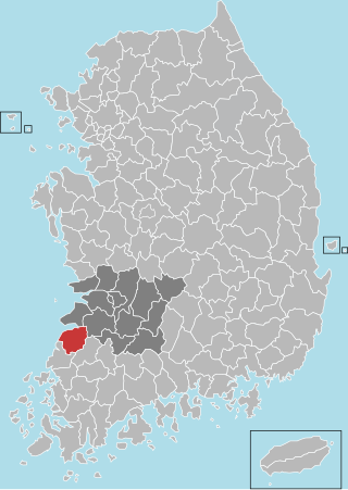
Gochang County is a county in North Jeolla Province, South Korea. It is a rural area, and is home to only one institution of higher education: Gochang Polytechnic College.

<span class="mw-page-title-main">Wanju County</span> County in Honam, South Korea

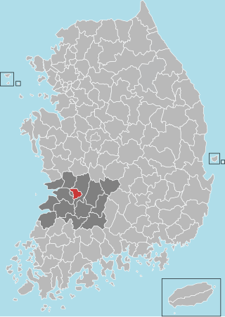
Wanju County is a county in North Jeolla province, South Korea. It almost entirely surrounds the city of Jeonju.

<span class="mw-page-title-main">Seosan</span> Municipal City in Chungcheong, South Korea

Seosan is a city in South Chungcheong Province, South Korea, with a population of roughly 175,000 according to the 2017 census. Located at the northwestern end of South Chungcheong Province, it is bounded by Dangjin City, Naepo New Town, Yesan-gun and Hongseong-gun on the east, Taean-gun and the Yellow Sea on the west, 125 km (78 mi) south of Seoul, 159 km (99 mi) northwest of Daejeon and 34 km (21 mi) northwest of Naepo New Town. Seosan is the hub of transportation of the west coast where the Seohaean Expressway, Daejeon-Dangjin Expressway, National Highways No. 29, 32, 38 and 45 intersect.

<span class="mw-page-title-main">Geumsan County</span> County in South Chungcheong Province, South Korea

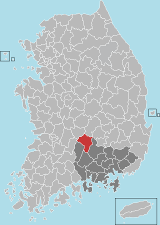
Geumsan County is a county in South Chungcheong Province, South Korea. It borders Muju County, North Jeolla Province (Jeollabuk-do), which is famous for its ski resort nearby.

<span class="mw-page-title-main">Geochang County</span> County in Yeongnam, South Korea

Geochang County is a county in South Gyeongsang Province, South Korea. The Geochang International Festival of Theater, which was started in 1989, is renowned as the best play festival in Korea. The District Office is located in Geochang-eup, and has jurisdiction over 1 eup and 11 myeon.

<span class="mw-page-title-main">Hadong County</span> County in Yeongnam, South Korea

Hadong County is a county in South Gyeongsang Province, South Korea. It is on the far-west side of the province, bordering South Jeolla Province. The county office is located at Hadeong-eup.

<span class="mw-page-title-main">Korean architecture</span>

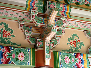
Korean architecture refers to an architectural style that developed over centuries in Korea. Throughout the history of Korea, various kingdoms and royal dynasties have developed a unique style of architecture with influences from Buddhism and Korean Confucianism.

<span class="mw-page-title-main">Jogye Order</span> Korean Buddhist order

The Jogye Order, officially the Jogye Order of Korean Buddhism, is the representative order of traditional Korean Buddhism with roots that date back 1200 years to the Later Silla National Master Doui, who brought Seon and the practice taught by the Sixth Patriarch, Huineng, from China around 820 CE. The name of the Order, Jogye, was adopted from the name of the village where Patriarch Huineng's home temple, Nanhua Temple, is located,.

<span class="mw-page-title-main">Donghwasa</span> Buddhist temple in Daegu, South Korea

Donghwasa (Korean: 동화사), also Donghwa Temple, is a Buddhist temple of the Jogye Order in northern Daegu, South Korea. The temple is located on the south side of Mt. Palgongsan, within the boundaries of Dohak-dong, Dong-gu, near Daegu's northern border. The name means "Temple of Paulownia Blossoms."

<span class="mw-page-title-main">Jikjisa</span> Buddhist temple in Gimcheon, South Korea

Jikjisa is a head temple of the Jogye Order of Seon Buddhism. It is located on the slopes of Hwangaksan in Daehang-myeon, Gimcheon, North Gyeongsang Province, South Korea. It may be one of the oldest temples in South Korea.

<span class="mw-page-title-main">Samnyeonsanseong</span>

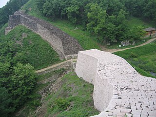
Samnyeon Sanseong Fortress is the ruins of a Silla fortress and wall that was built beginning in the year 470. The fortress was reconstructed in 486. The ruins are located in present-day Boeun, South Korea. During the Three Kingdoms Period the town of Boeun-eup, located two kilometers from the fortress, was known as Samnyeon-gun or Samnyeonsan-gun and it is believed by some that the fortress gets its name from the town. However, the Samguk Sagi relates that the fortress was completed in three years, and that the fortress derived its name from this fact. This account also suggests that the nearby town derived its name from the fortress, rather than vice versa. The Annals of Joseon Dynasty show that the fortress was known as Ojeong Sanseong Fortress and was used during the Joseon Dynasty, probably because the fortress is located atop Mount Ojeongsan.

Korean Buddhist sculpture is one of the major areas of Korean art. Buddhism, a religion originating in what is now India, was transmitted to Korea via China in the late 4th century. Buddhism introduced major changes in Korean society. The complexity of the religious sutras sent to Korea required the aristocrats who adopted the religion to become literate and required the training and importation of literate scribes. Little evidence of religious art exists in Korea before the introduction of Buddhism. Subsequent to its introduction, the religion inspired the production of devotional art as well as the beginnings of sophisticated temple architecture.

<span class="mw-page-title-main">Silsangsa</span> Korean Buddhist temple

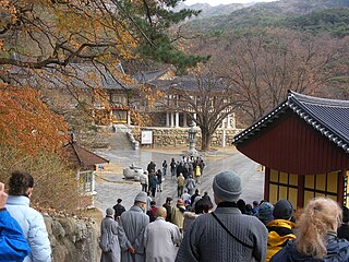
Silsangsa Temple is a temple of the Jogye Order located in Namwon, North Jeolla Province, South Korea. The temple is a branch temple of the Geumsan Temple in Iksan. Although the temple is legally situated in Namwon, it is also quite near the Hamyang county of South Gyeongsang Province. It is exceptional since this temple is in a field, as opposed to most Korean temples, which are located in mountainous areas.

References

  1. 1 2 3 4 5 6 "Hamyang Cultural Assets". hygn.go.kr. Retrieved 2022-01-16.
  2. 1 2 3 "Hamyang Sageunsanseong Fortress". dh.aks.ac.kr. Retrieved 2021-01-16.
  3. "Namgyeseowon Confucian Academy, Hamyang". Cultural Heritage Administration . Retrieved 2022-01-16.
  4. Min Deok-gi (Cheongju University). "The Battle of Hwangseoksanseong Fortress and Baeksarim of Gimhae Busa". DBpia . Retrieved 2022-01-16.
  5. "Climatological Normals of Korea (1991 ~ 2020)" (PDF) (in Korean). Korea Meteorological Administration. Archived from the original (PDF) on 29 January 2022. Retrieved 7 June 2023.
  6. 순위값 - 구역별조회 (in Korean). Korea Meteorological Administration. Retrieved 4 April 2022.
  7. "Sister City Campaign – Hamyang, South Korea – Montgomery Township, Pennsylvania". koreandogs.org. 2017-03-17. Retrieved 2022-01-17.

35°31′14″N127°43′30″E / 35.52056°N 127.72500°E / 35.52056; 127.72500