Sweetwater County is a county in southwestern Wyoming, United States. As of the 2010 United States Census, the population was 43,806. Its county seat is Green River. By area, it is the largest county in Wyoming. Its southern boundary line abuts the north lines of the states of Colorado and Utah.

Laramie is a city in and the county seat of Albany County, Wyoming, United States. The population was 30,816 at the 2010 census. Located on the Laramie River in southeastern Wyoming, the city is west of Cheyenne, at the junction of Interstate 80 and U.S. Route 287.
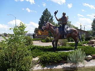
Rock Springs is a city in Sweetwater County, Wyoming, United States. The population was 23,036 at the 2010 census, making it the 5th most populated city in the state of Wyoming, and the most populous city in Sweetwater County. Rock Springs is the principal city of the Rock Springs micropolitan statistical area, which has a population of 37,975. Rock Springs is known as the Home of 56 Nationalities because of the influx of immigrants from all over the world who came to work in the coal mines that supplied the fuel to power the steam engines of the Union Pacific Railroad. The city's rich cultural heritage is celebrated each summer on International Day, a festival where the foods, costumes, and traditions of residents' ancestors are recreated and enjoyed at Bunning Park in downtown Rock Springs.

The Bouncing Souls are an American punk rock band from New Brunswick, New Jersey, formed in 1989. By the time of their acknowledgment by the national punk rock scene, they had reignited a "pogo" element to New Jersey punk rock by playing fast light-hearted songs, a model followed by various other local bands.
Sugarcult is an American rock band from Santa Barbara, California formed in 1998. The band currently consists of Tim Pagnotta, Airin Older, Marko DeSantis, and Kenny Livingston.

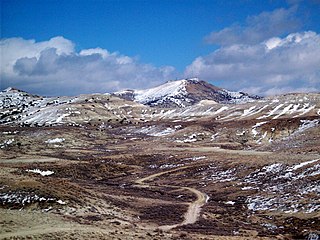
The Granite Mountains are a short subrange of the Rocky Mountains in central Wyoming of the United States. The range runs approximately 100 mi (160 km) E-W along the south side of the Shoshone Basin, and north of the Sweetwater River, in eastern Fremont County and western Natrona County. The highest point is McIntosh Peak at 8,058 feet (2,456 m). Independence Rock is at the east end of the range, and Split Rock was a prominent landmark on the Oregon Trail. The region is rich in uranium and other mineral deposits.

Independence Rock is a large granite rock, approximately 130 feet (40 m) high, 1,900 feet (580 m) long, and 850 feet (260 m) wide, which is in southwestern Natrona County, Wyoming along Wyoming Highway 220. During the middle of the 19th century, it formed a prominent and well-known landmark on the Oregon, Mormon, and California emigrant trails. Many of these emigrants carved their names on it, and it was described by early missionary and explorer Father Pierre-Jean De Smet in 1840 as the Register of the Desert. The site was designated a National Historic Landmark on January 20, 1961 and is now part of Independence Rock State Historic Site, owned and operated by the state of Wyoming.

The Medicine Bow Mountains are a mountain range in the Rocky Mountains that extend for 100-mile (160 km) from northern Colorado into southern Wyoming. The northern extent of this range is the sub-range the Snowy Range. From the northern end of Colorado's Never Summer Mountains, the Medicine Bow mountains extend north from Cameron Pass along the border between Larimer and Jackson counties in Colorado and northward into south central Wyoming. In Wyoming, the range sits west of Laramie, in Albany and Carbon counties to the route of the Union Pacific Railroad and U.S. Interstate 80. The mountains often serve as a symbol for the city of Laramie. The range is home to Snowy Range Ski Area.
Teenage Bottlerocket is an American punk rock band formed in Laramie, Wyoming, United States in 2000.

The Rock Springs massacre, also known as the Rock Springs Riot, occurred on September 2, 1885, in the present-day United States city of Rock Springs in Sweetwater County, Wyoming. The riot, and resulting massacre of immigrant Chinese miners by white immigrant miners, was the result of racial prejudice toward the Chinese miners, who were perceived to be taking jobs from the white miners. The Union Pacific Coal Department found it economically beneficial to give preference in hiring to Chinese miners, who were willing to work for lower wages than their white counterparts, angering the white miners. When the rioting ended, at least 28 Chinese miners were dead and 15 were injured. Rioters burned 78 Chinese homes, resulting in approximately US$150,000 in property damage.
Thom Wilson was an American punk rock record producer and engineer.
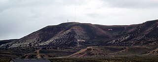
Wilkins Peak is a small mountain located in Sweetwater County, Wyoming, between the cities of Green River and Rock Springs. It is primarily used for radio and television station transmitters, but it also serves radio needs of the FAA, EMS, and local businesses such as Questar Gas. In 2003, a tower on the peak was knocked down by a vehicle delivering propane to customers. The tower was owned by Wyoming Public Radio and was serving the local area with programming from National Public Radio. There are numerous access roads to the peak and it is not gated and open year-round, weather permitting. Along with the radio uses, the mountain is also a popular location for mountain biking and hiking. The mountain contains geology typical of its location in southwestern Wyoming.

There is evidence of prehistoric human habitation in the region known today as the U.S. state of Wyoming stretching back roughly 13,000 years. Stone projectile points associated with the Clovis, Folsom and Plano cultures have been discovered throughout Wyoming. Evidence from what is now Yellowstone National Park indicates the presence of vast continental trading networks since around 1000 years ago. The Union Pacific Railroad played a central role in the European settlement of the area. Wyoming became a U.S. territory in 1868 and became the 44th U.S. state in 1890. It was the first state to grant women the right to vote, in 1869.
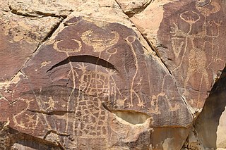
Legend Rock Petroglyph Site is located in Hot Springs County, Wyoming, 20 miles northwest of Hot Springs State Park. Legend Rock is a petroglyph site which features hundreds of individual petroglyphs spread across the face of the rock. Although a handful of the rock's etchings have variously been eroded and defaced, a wide majority have been preserved for public viewing. The nearly 300 individual petroglyphs feature some of the oldest and best examples of Dinwoody rock art in the world. The origins of the petroglyphs are still subject to debate. The site was listed on the National Register of Historic Places on July 5, 1973. and it is preserved by the state of Wyoming as a state historic site.
White Mountain is a long mountain located in central Sweetwater County, Wyoming, near the cities of Rock Springs and Green River. The mountain is part of the Green River Formation, and contains communications towers that serve a number of purposes. Hundreds of carved figures also dot the sandstone cliffs at the White Mountain Petroglyph site and range from 200 to 1000 years old. Pilot Butte, located on top of White Mountain, is accessible from roads on the mountain.

Rock of Ages is located in the Teton Range, Grand Teton National Park in the U.S. state of Wyoming. Rock of Ages is .50 miles (0.80 km) ESE of The Jaw and on the south side of Hanging Canyon.
This is a discography of The Bouncing Souls, a New Jersey-based punk rock band. The band was formed in 1989.