Sleepy Hollow may refer to:

"The Legend of Sleepy Hollow" is a gothic story by American author Washington Irving, contained in his collection of 34 essays and short stories entitled The Sketch Book of Geoffrey Crayon, Gent.. Written while Irving was living abroad in Birmingham, England, "The Legend of Sleepy Hollow" was first published in 1820. Along with Irving's companion piece "Rip Van Winkle", "The Legend of Sleepy Hollow" is among the earliest examples of American fiction with enduring popularity, especially during Halloween because of a character known as the Headless Horseman believed to be a Hessian soldier who was decapitated by a cannonball in battle.

Campbell County is a county in the U.S. state of Wyoming. As of the 2010 United States Census, the population was 46,133, making it the third-most populous county in Wyoming. Its county seat is Gillette.

Sleepy Hollow is a census-designated place (CDP) in Campbell County, Wyoming, United States. The population was 1,308 at the 2010 census.

Wasatch-Cache National Forest is a United States National Forest located primarily in northern Utah (81.23%), with smaller parts extending into southeastern Idaho (16.42%) and southwestern Wyoming (2.35%). The name is derived from the Ute word Wasatch for a low place in high mountains, and the French word Cache meaning to hide. The term cache originally referred to fur trappers, the first Europeans to visit the land. The Wasatch-Cache National Forest boundaries include 1,607,177 acres (6,504.01 km2) of land.
Doug Engebretson is an American author and historian. His best-known work is "Empty Saddles, Forgotten Names: Outlaws of the Black Hills and Wyoming" (1982), which includes accounts of early-day outlaws operating in Wyoming and the neighboring Black Hills of South Dakota.

Hollow Triumph is a 1948 American film noir crime drama directed by Steve Sekely starring Paul Henreid and Joan Bennett. It was released by Eagle-Lion Films, based on the 1946 novel of the same title written by Murray Forbes.

The Carmel Formation is a geologic formation in the San Rafael Group that is spread across the U.S. states of Wyoming, Utah, Colorado, north east Arizona and New Mexico. Part of the Colorado Plateau, this formation was laid down in the Middle Jurassic during the late Bajocian, through the Bathonian and into the early Callovian stages.
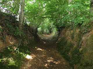
A sunken lane is a road or track that is significantly lower than the land on either side, not formed by the (recent) engineering of a road cutting but possibly of much greater age.
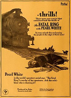
The Fatal Ring is a 1917 American action film serial directed by George B. Seitz. Silentera.com reports that the UCLA Film and Television Archive may have a complete print.

The Seven Pearls is a 1917 American silent action film serial directed by Louis J. Gasnier and Donald MacKenzie. It is considered to be a lost film, though fragmentary prints are held by the Library of Congress.

The Big Hollow is a wind eroded deflation basin located to the west of Laramie, Wyoming in the United States. It is the second largest wind eroded depression in the world. The Big Hollow is the largest deflation basin in North America. The Big Hollow is younger than the alluvial valley floors which now form its boundaries and is therefore of Late Pleistocene age. During most of the Pleistocene the Big Hollow was actually a hill composed of soft sedimentary bedrock. The material making up this former hill was much more easily eroded than the alluvial valley floors which bounded it to both the north and south. Eventually, the hill was washed and blown away and then the wind continued to erode a deflation basin into the soft bedrock. Eventually the former hill became lower than the river channels which once flowed around it. The geologists call this "topographic reversal". The Qattara Depression near Cairo, Egypt is the largest. The Big Hollow is an undrained basin and is 11 miles (18 km) long, 4 miles (6.4 km) wide, and up to 200 feet (61 m) deep. Oil was discovered in 1917 and the basin has been productive since. The basin is listed on the National Natural Landmark list.

This is a list of the National Register of Historic Places listings in Converse County, Wyoming.
Wilcox is a populated place in Albany County, Wyoming, United States of America.
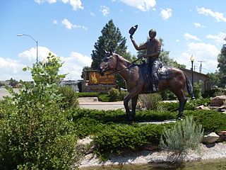
The Wilcox Train Robbery also known as the Wilcox Holdup was a Train robbery that took place in the early morning of June 2, 1899 in the vicinity of Wilcox, Wyoming. A Union Pacific train was flagged down before it could cross a wooden bridge. Armed men forced the train crew to separate the locomotive from the carriages. Once the unattached locomotive had been driven across the bridge, the bridge was destroyed with dynamite. A safe in one of the carriages was blown open by dynamite, and the robbers escaped with cash and other valuables. The amount stolen was reported as much as US$36,000.

Sugar Hollow Creek is a tributary of Bowman Creek in Wyoming County, Pennsylvania, in the United States. It is approximately 4.7 miles (7.6 km) long and flows through Mehoopany Township and Eaton Township. The watershed of the creek has an area of 7.07 square miles (18.3 km2). The creek is not designated as an impaired waterbody. The surficial geology near its mouth consists of alluvium, Wisconsinan Outwash, and Wisconsinan Till. The creek is a High-Quality Coldwater Fishery, a Migratory Fishery, and Class A Wild Trout Waters.
Several sections of the Bozeman Trail in Wyoming are listed on the National Register of Historic Places. Typically there are sections of trail that are concentrated at geographic features such as fords or crossings of divides, where the trail consolidates from a broad swath of parallel, poorly defined paths to a small area where remnants of the trail are visible.