
The Gulf of Saint Lawrence is the outlet of the North American Great Lakes via the Saint Lawrence River into the Atlantic Ocean. The gulf is a semienclosed sea, covering an area of about 226,000 square kilometres (87,000 sq mi) and containing about 34,500 cubic kilometres (8,300 cu mi) of water, which results in an average depth of 152 metres (499 ft).

The Arctic Archipelago, also known as the Canadian Arctic Archipelago, is a group of islands north of the Canadian mainland.
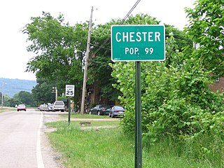
Chester is a town in Crawford County, Arkansas, United States. It is part of the Fort Smith, Arkansas-Oklahoma Metropolitan Statistical Area. As of the 2010 Census the population was 159. The population was 99 at the 2000 census.

Granby is a statutory town which is the most populous municipality in Grand County, Colorado, United States. Granby is situated along U.S. Highway 40 in Middle Park about 85 miles (137 km) northwest of Denver and 14 miles (23 km) southwest of Rocky Mountain National Park. As of the 2010 census the town had a population of 1,864.

Shannon is a village in Carroll County, Illinois, United States. The population was 757 at the 2010 census, down from 854 in 2000.

Rutledge is a village in Scotland County, Missouri, United States. The population was 109 at the 2010 census.
South Floral Park is a village in Nassau County, New York, United States. United States. The population was 1,764 at the 2010 census.
Reilly Township is a township in Schuylkill County, Pennsylvania, United States. The population was 802 at the 2000 census.

Jubail is a city in the Eastern province on the Persian Gulf coast of Saudi Arabia. It is the largest industrial city in the world. It is also home to the Middle East's largest and world's fourth largest petrochemical company SABIC. It has the world's largest IWPP producing 2743.6 MW of electricity and 800,000 m3 of water daily. Jubail comprises the Old Town of Al Jubail, which was a small fishing village until 1975 and the new industrial area. Jubail Industrial City is the largest civil engineering project in the world today.

This is a list of the extreme points of North America: the points that are highest and lowest, and farther north, south, east or west than any other location on the continent. Some of these points are debatable, given the varying definitions of North America.

Jiunjiunde is a village in the Bassar Prefecture in the Kara Region of north-western Togo.
Agbande is a village in the Doufelgou Prefecture in the Kara Region of north-eastern Togo.

Arakht is a village in Badakhshan Province in north-eastern Afghanistan.
This is a list of the extreme points and extreme elevations in Scotland.
Pudupakkam is a village near Chennai, India. It is closer to Siruseri SIPCOT. This village comes under Chengalpet taluk of Kancheepuram district in Tamil Nadu. Nearby hospitals include Chettinadu Health City,global hospitals and Tagore medical college hospital.it has reputed Dr. Ambedkar Government Law College. The opening of an IT park in Siruseri, has led to an increase in apartments and villas in the region.
The Japanese submarine Ro-106 was a Ro-100-class submarine built for the Imperial Japanese Navy during World War II.
German submarine U-356 was a Type VIIC U-boat of Nazi Germany's Kriegsmarine during World War II. The submarine was laid down in May 1940 at the Flensburger Schiffbau-Gesellschaft yard at Flensburg, launched on 16 September 1941, and commissioned on 20 December 1941.
German submarine U-667 was a Type VIIC U-boat built for Nazi Germany's Kriegsmarine for service during World War II. She was laid down on 16 August 1941 by Deutsche Werft, Hamburg as yard number 816, launched on 29 August 1942 and commissioned on 21 October 1942 under Kapitänleutnant Heinrich Schroeteler.

German submarine U-951 was a Type VIIC U-boat of Nazi Germany's Kriegsmarine during World War II.


