ISO 31 is a deprecated international standard for the use of physical quantities and units of measurement, and formulas involving them, in scientific and educational documents. It is superseded by ISO/IEC 80000.
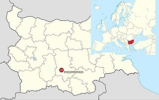
The Siege of Philippopolis was fought in about 250 between Rome and the Goths during the invasions of 249–253 at the Thracian city of Philippopolis, modern Plovdiv, Bulgaria. It was part of the long-running series of Gothic Wars.
Salak Tinggi is a town in Sepang region in southern Selangor, Malaysia. Located about 9 km north of the Kuala Lumpur International Airport, it is the seat of the Sepang district's administration.
Klinča Sela is a municipality in Zagreb County, Croatia. According to the 2001 census, there are 4,927 inhabitants.

Roșia is a large commune in Romania, Bihor County, around 21 kilometers north from the town of Beiuș. It is composed of two villages, Lazuri (Lázurihegy) and Roșia.
The Alkali Lake Indian Band, also known as the Esketemc First Nation, is a First Nations government of the Secwepemc (Shuswap) people, located at Alkali Lake in the Cariboo region of the Central Interior of the Canadian province of British Columbia. It was created when the government of the then-Colony of British Columbia established an Indian Reserve system in the 1860s. It is one of three Secwepemc bands that is not a member of either the Shuswap Nation Tribal Council or the Northern Shuswap Tribal Council.

Dĩ An is a town of Bình Dương Province in the Southeast region of Vietnam, about 20 km north of Ho Chi Minh City. It is 1706 km by rail from Hanoi. At the 2009 census the town had a population of 73,859. The town covers 60 km².
Odherwal is a village and union council, an administrative subdivision, of Chakwal District in the Punjab Province of Pakistan, it is part of Chakwal Tehsil and is located at 32°56'0N 72°48'0E.

Piyaro Lund is a town and union council of Tando Allahyar District in the Sindh Province of Pakistan name="Tand">Official website of District Government Tando AllahyarArchived 2013-05-21 at the Wayback Machine</ref> it has a population of 23,613. It is part of Jhando Mari Taluka and is located in the south of the district at 25°33′0″N68°48′0″E.
Mahra is a town and union council in Dera Ismail Khan District of Khyber-Pakhtunkhwa. It is located at 31°30'0N 70°45'0E and has an altitude of 154 metres.
Nara is a village and union council of Jhelum District in the Punjab Province of Pakistan. It is part of Jhelum Tehsil, and is located at 32°48'0N 73°24'0E with an altitude of 236 metres (777 feet). Union council number 1 of jhelum.It has about 150 houses mostley populated by Maliks. It is about 45 kilometres from main city which is jhelum

Leszkomin is a village in the administrative district of Gmina Zadzim, within Poddębice County, Łódź Voivodeship, in central Poland. It lies approximately 8 kilometres (5 mi) south-east of Zadzim, 17 km (11 mi) south of Poddębice, and 37 km (23 mi) west of the regional capital Łódź.

Jalalabad is a village in the Sargodha District of Punjab, Pakistan. It is located at 32°13'54N 72°48'0E, and has an altitude of 190 metres.
Kohali is a village and union council of Jhelum District in the Punjab province of Pakistan. It is part of Sohawa Tehsil, and located at 31°8'0N 72°48'0E with an altitude of 166 metres (547 feet).
Batu Niah is a small town in Sarawak, Malaysia. It is located at 3°48'0" N, 113°45'0" E on the island of Borneo.
Trás-os-Montes was one of the 13 regions of continental Portugal identified by geographer Amorim Girão, in a study published between 1927 and 1930.
Beni Dergoun is a town and commune in Relizane Province, Algeria.
Konstvägen sju älvar is a tourist and sculpture route in Västerbotten in North Sweden that travels 350 kilometers in from the coast.
Abdi is one of three departments in Ouaddaï, a region of Chad. Its capital is Abdi.


