
Alindao is a town and sub-prefecture located in the Central African Republic prefecture of Basse-Kotto. It lies at the junction of the National Route 2 and 22. Alindao had a population of 14,401 as of the 2003 census; and a calculated 2013 population of 15,213. The town is the seat of the Roman Catholic Diocese of Alindao. It has a small airport, Alindao Airport. A Catholic Mission was established at Alindao during French occupation under French Equatorial Africa.

Ramree is a town in Kyaukpyu district, Southern Rakhine State of western Myanmar. Ramree is situated on Ramree Island.

Rudsar County is a county in Gilan Province in Iran. The capital of the county is Rudsar. At the 2006 census, the county's population was 144,576, in 42,004 families. The county is subdivided into four districts: the Central District, Chaboksar District, Kelachay District, and Rahimabad District. The county has five cities: Rudsar, Chaboksar, Kelachay, Rahimabad, and Vajargah.
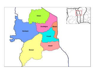
Assoli is a prefecture located in the Kara Region of Togo. The capital city is Bafilo.

Kadan Kyun is the largest island in the Mergui Archipelago, Myanmar. Its area is 450 km². The highest point is French Bay Peak, which is the highest point in the archipelago.

Ghungrila is a town in Gujar Khan Tehsil Punjab, Pakistan. Gungrila is also chief town of Union Council Gungrila which is an administrative subdivision of the Tehsil. It is located at 33°18'0"North, 73° 15' 0" East.
Bhamo Township is a township of Bhamo District in the Kachin State of Burma. The principal town is Bhamo.

Yovon is a town in Tajikistan located in the Khatlon province. In 2000, the town had an estimated population of 20,000. It is approximately 30 kilometres (20 mi) southeast of Dushanbe.

Toyotsu-Ueno Station is a railway station on the Nagoya Line in Tsu, Mie Prefecture, Japan, operated by the private railway operator Kintetsu Railway. Toyotsu-Ueno Station is 59.8 rail kilometers from the terminus of the line at Kintetsu Nagoya Station.

Boungbale is a town in the Bassar Prefecture in the Kara Region of Togo. Nearby towns and villages include Bongbon, Lidialabo (1.6 km [1.0 mi]), Demon (3.2 km [2.0 mi]), Diabirdo (3.2 km [2.0 mi]), and Tipakpane (3.5 km [2.2 mi]).
Pak Ou District is a district (muang) of Luang Prabang Province in northern Laos.
Agbande is a village in the Doufelgou Prefecture in the Kara Region of north-eastern Togo.
Natchiboura is a village in the Bassar Prefecture in the Kara Region of north-western Togo.

Koira is a village in Sundargarh District, Odisha, India.

Lindula is a town and Urban Council in Nuwara Eliya District in the Central Province of Sri Lanka. With Talawakele it forms the Talawakele-Linduala urban council.
Beor is a village and union councilsituated in the Kahuta Tehsil of Rawalpindi District, of Punjab, Pakistan. Its geographical coordinates are 33° 35' 0" North, 73° 34' 0" East.

Cascade is a settlement in Jamaica. Cascade is located at 18°29′04″N77°55′44″E.
Rahimabad District is a district (bakhsh) in Rudsar County, Gilan Province, Iran. The sole city in Rahimabad District, also called Rahimabad, is located west of the Caspian Sea at 35° 22' 54" North, 45° 7' 28" East, and lies at an altitude of 4,268 feet according to Maplandia.com. At the 2006 census, its population was 27,653, in 7,820 families. The District has one city: Rahimabad. The District has four rural districts (dehestan): Eshkevar-e Sofla Rural District, Rahimabad Rural District, Shuil Rural District, and Siyarastaq Yeylaq Rural District.
Uspenovka is a village in the Aktobe Region of western Kazakhstan.


