Ogun or Ogoun is a spirit that appears in several African religions. He was the first Ooni of Ife after the demise of Oduduwa. A warrior and a powerful spirit of metal work, as well as of rum and rum-making. He is also known as the 'god of Iron', and is present in Yoruba religion, Haitian Vodou, and West African Vodun.

A mausoleum is an external free-standing building constructed as a monument enclosing the interment space or burial chamber of a deceased person or people. A monument without the interment is a cenotaph. A mausoleum may be considered a type of tomb, or the tomb may be considered to be within the mausoleum.

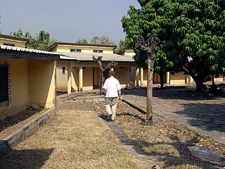
Kpalimé is a city in the Plateaux Region of Togo, 120 km north of Lomé and 15 km from the border with Ghana. It is the administrative capital of Kloto Prefecture. Kpalimé has a population of 75,084, making it the fourth-biggest town in Togo, after Lomé, Sokodé and Kara. The town has a cathedral, a scientific lycée, and a post-office, as well as several banks, medical centres, pharmacies, cyber-cafés and petrol stations.
El-Hadj Bonfoh Abass is a Togolese politician who was the interim President of Togo from February 25, 2005 to May 4, 2005. He was the President of the National Assembly of Togo from February 2005 to July 2013.

The Lossos are an ethnic and linguistic group of people living in the Doufelgou District (Préfecture) of the Kara Region in Northern Togo, West Africa. The district capital is Niamtougou which is also an important regional market town. The Lossos live on a plateau in the Togo Mountains between two mountain ranges: the Kabiyé Mountains to the South and the Défalé Chain to the North. They occupy the communities of Niamtougou, Koka, Baga, Ténéga, Siou, Djogrergou, Sioudouga, Kpadeba, Hago, Koukou, and Kounfaga. The Doufelgou District is bordered by the Kozah District to the South, by the Binah District to the East, by the Bassar District to the West, by the Kéran District to the North, and by the international border with Bénin to the Northeast.

Kara is one of Togo's five regions. Kara is the regional capital.

Topola is a town and municipality located in the Šumadija District of central Serbia. It was the place where Karađorđe, a Serbian revolutionary, was chosen as the leader of the First Serbian Uprising against the Ottoman Empire in 1804. The local St. George Church is the burial place of the Ducal and Royal Family of Serbia and Yugoslavia.

Jajpur is a town and a municipality in Jajpur district in the Indian state of Odisha. It was the capital of the Kesari dynasty, later supplanted by Cuttack. Now, it is the headquarter of Jajpur district.

dKara is a city in northern Togo, situated in Kara Region, 413 km north of the capital Lomé. Kara is the capital of the Kara region and, according to the 2010 census, had a population of 94,878. The Kara River flows through the city and is its main resource of water. The city developed from the 1970s onwards from the village originally known as Lama-Kara. Its growth was largely due to the influence of the previous Togolese head of state Gnassingbé Eyadéma who was born in the nearby village of Pya and understood Kara's strategic position at a crossroads of two trade routes.
Blitta is a prefecture and town located in the Centrale Region of Togo. Blitta has an area of 2,973 miles and there is roughly 200 or more villages in the area.
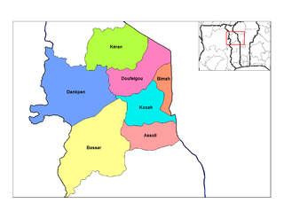
Dankpen is a prefecture located in the Kara Region of Togo. The prefecture covers 2 690 km², with a population in 2010 of 130 723. It is split into 12 cantons. The prefecture seat is located in Guérin-Kouka.
Bassar Prefecture is one of the prefectures of Togo and is located in Kara Region in Togo.

The Kwame Nkrumah Mausoleum and memorial park is located in downtown Accra, the capital of Ghana.

Boungbale is a town in the Bassar Prefecture in the Kara Region of Togo. Nearby towns and villages include Bongbon, Lidialabo (1.6 km [1.0 mi]), Demon (3.2 km [2.0 mi]), Diabirdo (3.2 km [2.0 mi]), and Tipakpane (3.5 km [2.2 mi]).
Jiunjiunde is a village in the Bassar Prefecture in the Kara Region of north-western Togo.
Natchiboura is a village in the Bassar Prefecture in the Kara Region of north-western Togo.

In the Bible, a scapegoat is one of two kid goats. As a pair, one goat was sacrificed and the living “scapegoat” was released into the wilderness, taking with it all sins and impurities. The concept first appears in Leviticus, in which a goat is designated to be cast into the desert to carry away the sins of the community.
Then Aaron shall lay both his hands on the head of the live goat, and confess over it all the iniquities of the people of Israel, and all their transgressions, all their sins, putting them on the head of the goat, and sending it away into the wilderness by means of someone designated for the task. The goat shall bear on itself all their iniquities to a barren region; and the goat shall be set free in the wilderness.
Adae Kese Festival is an important albeit rare celebration among the Ashantis in Ghana. It glorifies the achievements of the Asante kingdom. It was first celebrated to the achievement of statehood of the people, after the war that the Ashantis had their independence, in the Battle of Feyiase which they fought against the people of Denkyira. It is also the occasion when the purification ceremony of Odwira is performed at the burial shrines of ancestral spirits. Generally, this coincides with the harvest season of yam and hence the ritual was also called the "Yam custom" by Europeans. It is celebrated every two weeks by the people in accordance with the calendar of the Akans based on the cycle of forty-two days and nine months in their calendar. The festival is mostly held to climax celebrations of specific achievements and milestones of the people of the Ashanti kingdom. The festival is a day of rest so it is forbidden to work on that day.

The Ashanti Yam Festival is an annual celebration of the Ashanti people of Ashanti. It marks the first harvest of yams during the autumn season, after the monsoon season. The yam is the staple food crop in Ashanti and most of Africa.
The Konkomba people are a Gur ethnic group residing mainly in the Northern, Brong Ahafo, Volta, Eastern and Greater Accra Regions of Ghana. Saboba, Chereponi and Nanumba Districts, Gushiegu and Karaga districts, Zabzugu and Tatale-Sanguli districts in the Northern Region and the Nkwanta North and South Districts in the Volta Region are a few examples of administrative districts where Bikpakpaam are seen in huge populations. Other key towns of Bikpakpaam in Ghana are Atebubu, Kintampo, Techiman and Yeji in the Brong Ahafo Region. According to the Act 280 of the Anatomy act of Ghana, the Konkomba people are the second largest ethnic group in the Northern Region of Ghana. The 2010 census data indicates that Bikpakpaam in Ghana number 823,000 and applying the intercensal growth rate would give a population of more than one million now. CIA The World Factbook reports in Demographics of Ghana that Konkomba people are the 8th largest Ethnic group in Ghana representing 3.5% of the Total population of Ghana. Saboba (Chabob) in the Northern Region of Ghana is the capital town of all Bikpakpaam in Ghana. Bikpakpaam are also found in the republic of Togo, a sister West African country to Ghana. In Togo Bikpakpaam reside mainly in the Kara, Central and Plateaux Regions. Guerin Kouka in the Kara Region is the capital town of Bikpakpaam in Togo. Dankpen district is located in the north western corridor of Togo. In Schwartz's (2005) account, Bikpakpaam number about 50,100 in Togo. The 2011 census in Togo indicates however that the total population of Bikpakpaam in Dankpen district alone was 122,209. Visit Konkomba language for more information. Konkomba people speak Konkomba language a.k.a. Likpakpaln. The traditional dance of Konkomba people is Kinachunŋ. All Konkomba settlements are led by a traditional chief called Ubor. In Bikpakpaam dominant areas, the people have instituted or established their own chieftains who serve as overlords of the settlements. For instance, the Saboba area has the Uchabob-bor as the overlord. Bikpakpaam strongly believe in solidarity, determination and hard-work. Until the turn of the 21st century, their primary occupation was farming and animal husbandry. In occupational terms, Bikpakpaam are mainly subsistence farmers and rearers of animals such as poultry, small ruminants and cattle. This, probably, explains their scattered settlement across the West African sub-region. Indeed, Maasole intimates that Bikpakpaam have always been on the move, in search for fertile farmlands. Most Konkombas are actively in education today and a recent research projects that Konkombas will become a dominant force in politics, health, education and the civil society by 2025.