The Finger Lakes are a group of eleven long, narrow, roughly north–south lakes located directly south of Lake Ontario in an area called the Finger Lakes region in New York, in the United States. This region straddles the northern and transitional edge of the Northern Allegheny Plateau, known as the Finger Lakes Uplands and Gorges ecoregion, and the Ontario Lowlands ecoregion of the Great Lakes Lowlands.
Seneca Lake is the largest of the glacial Finger Lakes of the U.S. state of New York, and the deepest glacial lake entirely within the state. It is promoted as the lake trout capital of the world, and is host of the National Lake Trout Derby. Because of its depth and relative ease of access, the US Navy uses Seneca Lake to perform test and evaluation of equipment ranging from single element transducers to complex sonar arrays and systems. The lake takes its name from the Seneca nation of Native Americans. At the north end of Seneca Lake is the city of Geneva, New York, home of Hobart and William Smith Colleges and the New York State Agricultural Experiment Station, a division of Cornell University. At the south end of the lake is the village of Watkins Glen, New York, famed for auto racing and waterfalls.

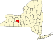
Yates County is a county in the U.S. state of New York. As of the 2020 Census, the population was 24,774, making it the third-least populous county in New York. The county seat is Penn Yan. The name is in honor of Joseph C. Yates, who as Governor of New York signed the act establishing the county.

Hammondsport is a village in Steuben County, New York, United States. First settled in 1792 the village is located at the south end of Keuka Lake, one of the Finger Lakes. In the 1850s vineyards and the wine industry began to emerge in and around Hammondsport. Pioneer aviation engineer Glenn Curtiss was born in Hammondsport, where he built several types of aircraft, and the first seaplanes, which were tested in Keuka Lake. Hammondsport features a village square, historic buildings, wineries, breweries and museums. Nearby municipalities contain vineyards, and wineries and grape-packing have played a major role in the economy. In 1935, heavy rains lasting three days resulted in mudslides and major flooding, ruining or damaging many homes and structures in Hammondsport, situated at the hillside. A number of buildings surrounding Pulteney Square make up the Pulteney Square Historic District and are listed in the National Register of Historic Places
Somers is a town located in northern Westchester County, New York, United States. As of the 2010 census, the town had a population of 20,434. The nearby Metro-North Commuter Railroad provides service to Grand Central Terminal in Manhattan with an average commute time of 65 to 75 minutes from stations at Purdys, Goldens Bridge, Croton Falls, and Katonah.

Barrington is a town in Yates County, New York, United States. The population was 1,681 at the 2010 census.

Benton is a town in Yates County, New York, United States. The population was 2,836 at the 2010 census. The town is named after an early resident, Levi Benton (1746-1820)

Dresden is a village in Yates County, New York, United States. The population was 308 at the 2010 census. The village was named after Dresden in Germany.

Jerusalem is a town in Yates County, New York. The population was 4,405 at the 2020 census. The town is named after the city of Jerusalem.

Milo is a town in Yates County, New York, United States. The population was 7,006 at the 2010 census. The town was named after Milo of Croton, a famous athlete from Ancient Greece.
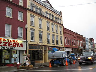
Penn Yan is an incorporated village and the county seat of Yates County, New York, United States. The population was 5,159 at the 2010 census. It lies at the north end of the east branch of Keuka Lake, one of the Finger Lakes. Penn Yan, New York is home to one of the oldest mills in the United States, The Birkett Mills, founded in 1797.

Keuka Lake is one of the major Finger Lakes in the U.S. state of New York. It is unusual because it is Y-shaped, in contrast to the long and narrow shape of the other Finger Lakes. Because of its shape, it was referred to in the past as Crooked Lake. Keuka means "canoe landing" or "lake with an elbow" in the Seneca language. The first white settlers to the lake region came after the Sullivan Expedition during the American Revolutionary War. In 1833 the Crooked Lake Canal was completed, connecting Keuka Lake with Seneca Lake, connecting with the Erie Canal. Beginning in the first half of the 19th century many steamboats operated on the lake which largely functioned as transports between Penn Yan and Hammondsport, often in service of the wine industry. In 1872 the Bath & Hammondsport Railroad, connecting to the Erie Railroad, went into operation, replacing the use of the canal. Beginning in the mid 19th century the lake has since been surrounded by vineyards and wineries which earned it the title, the Cradle of the Wine Industry, in New York. During the beginning of the 20th century the first water-craft airplanes were developed and tested on Keuka Lake by aviation pioneer Glenn Curtiss.

Keuka Lake State Park is a 621-acre (2.51 km2) state park located in Yates County, New York. The park is located on the north end of the west branch of Keuka Lake, one of the Finger Lakes. The park is in the southeast part of the town of Jerusalem, southeast of Branchport.

YMCA Camp Lawrence Cory, better known as "YMCA Camp Cory" or simply "Camp Cory," is a resident-style summer camp in the Finger Lakes region of upstate New York. It was founded in 1892 and established at its current location in 1921. The name comes from Lt. H. Lawrence Cory, an American World War I soldier who was killed in action.

New York State Route 14A (NY 14A) is a north–south state highway located in the Finger Lakes region of New York in the United States. It extends for 35.99 miles (57.92 km) from an interchange with NY 14 in the Schuyler County town of Reading to an intersection with U.S. Route 20 (US 20) and NY 5 west of the Ontario County city of Geneva. In between, the two-lane route serves Yates County and the village of Penn Yan, located at the northeastern tip of Keuka Lake. Outside of Penn Yan, NY 14A traverses rural, rolling terrain dominated by farmland.

New York State Route 54 (NY 54) is a state highway in the Finger Lakes region of New York in the United States. The southern terminus of the route is at an interchange with the Southern Tier Expressway in the village of Bath in Steuben County. Its northern terminus is at an intersection with NY 14 in the village of Dresden in Yates County. The section of NY 54 from Penn Yan to Dresden is signed as east–west. NY 54 serves as the eastern lakeside road along Keuka Lake. NY 54A, NY 54's alternate route between Hammondsport and Penn Yan, runs along the western and northern lakeshore.

New York State Route 54A (NY 54A) is a state highway in the western part of New York in the United States. It runs in a northeast to southwest direction through part of the Finger Lakes district of New York. The southern terminus of NY 54A is at NY 54 south of Hammondsport. The northern terminus is in Penn Yan, where it rejoins NY 54. Unlike NY 54, which runs along the east side of Keuka Lake, NY 54A has a more circuitous route around the western side of the lake.

Esperanza, also known as John Rose House, is a historic home located at Jerusalem in Yates County, New York. It is a Greek Revival style structure with a 2+1⁄2-story, side-gabled main block and a 1+1⁄2-story, side-gabled west wing. It was built in 1838 and features a massive 2-story portico composed of four Ionic columns supporting a full entablature and pediment. The mansion is ideally situated on Keuka Lake in Yates County, near several wineries. The Seneca Lake Wine Trail is minutes away.

Crooked Lake Outlet Historic District is a national historic district located near Penn Yan in Yates County, New York. The district is located along a seven-mile recreational trail that parallels the Keuka Lake Outlet. The district includes several mill sites along the gorge. It also includes nine areas that contain surface and subsurface archaeological remains.

The Arkansas River Valley is a region in Arkansas defined by the Arkansas River in the western part of the state. Generally defined as the area between the Ozark and Ouachita Mountains, the River Valley is characterized by flat lowlands covered in fertile farmland and lakes periodically interrupted by high peaks. Mount Magazine, Mount Nebo, and Petit Jean Mountain compose the Tri-Peaks Region, a further subdivision of the River Valley popular with hikers and outdoors enthusiasts. In addition to the outdoor recreational activities available to residents and visitors of the region, the River Valley contains Arkansas's wine country as well as hundreds of historical sites throughout the area. It is one of six natural divisions of Arkansas.