
East Chicago is a city in Lake County, Indiana, United States. The population was 26,370 at the 2020 census. Centered around heavy industry, the city is home to the Indiana Harbor and Ship Canal, an artificial freshwater harbor characterized by industrial and manufacturing activity.

Times Beach is a ghost town in St. Louis County, Missouri, United States, 17 miles (27 km) southwest of St. Louis and 2 miles (3 km) east of Eureka. Once home to more than two thousand people, the town was completely evacuated early in 1983 due to TCDD contamination, formerly the largest civilian exposure to the compound in the history of the United States.
Belmont Cragin is one of 77 officially designated Chicago community areas located on the Northwest Side of the City of Chicago, Illinois. It is designated Community Area 19, and is located 8 miles (13 km) NW of the Loop. Surrounding community areas include: Portage Park, Hermosa, Austin, Montclare, Dunning.

The Near South Side is a community area of Chicago, Illinois, United States, just south of the downtown central business district, the Loop. The Near South Side's boundaries are as follows: North—Roosevelt Road ; South—26th Street; West—Chicago River between Roosevelt and 18th Street, Clark Street between 18th Street and Cermak Road, Federal between Cermak Road and the Stevenson Expressway just south of 25th Street, and Clark Street again between the Stevenson and 26th Street; and East—Lake Michigan.

South Deering, located on Chicago's far South Side, is the largest of the 77 official community areas of that city. Primarily an industrial area, a small residential neighborhood exists in the northeast corner and Lake Calumet takes up a large portion of the area. 80% of the community area is zoned as industrial, natural wetlands, or parks. The remaining 20% is zoned for residential and small-scale commercial uses. It is part of the 10th Ward, once under the control of former Richard J. Daley ally Alderman Edward Vrdolyak.

Hegewisch is one of the 77 community areas of Chicago, Illinois, located on the city's far south side. It is bordered by the neighborhoods of Riverdale and South Deering to the west, the East Side to the north, the village of Burnham to the south and the city of Hammond, Indiana to the east. The community area is named for Adolph Hegewisch, the president of U.S. Rolling Stock Company who hoped to establish "an ideal workingman's community" when he laid out the town along a rail line in 1883, six years before Chicago annexed the town.
Carthay is a half-square-mile neighborhood in Central Los Angeles, California. It contains Carthay Circle, Carthay Square and South Carthay. There are three Los Angeles Historic Preservation Overlay Zones in Carthay.
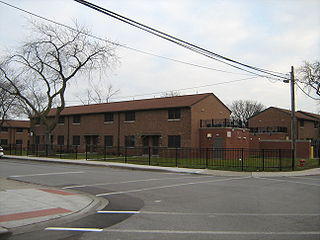
Altgeld Gardens Homes is a Chicago Housing Authority (CHA) public housing project on the far south side of Chicago, Illinois, United States, on the border of Chicago and Riverdale, Illinois. The residents are 97% African-American according to the 2000 United States Census. Built between 1944 and 1945 with 1,498 units, the development consists primarily of two-story row houses spread over 190 acres (0.77 km2).

Miller Beach is a neighborhood of Gary, Indiana on the southernmost shore of Lake Michigan. First settled in 1851, Miller Beach was originally an independent town. However, the "Town of Miller" was eventually annexed by the then flourishing city of Gary in 1918. Located in the northeastern corner of Lake County, Indiana, the former town is now known as "The Miller Beach Community." Miller Beach borders Lake Michigan to the north, Porter County to the east, and is largely surrounded by protected lands, including Indiana Dunes National Park. Miller Beach is also the closest beach/resort community to Chicago, and has been a popular vacation spot since the early 20th century. As of the 2000 US census, it had a population of 9,900.

Marktown is an urban planned worker community in East Chicago, Indiana, United States, built during the Progressive Era in 1917 from marshland to provide a complete community for workers at The Mark Manufacturing Company.

Boynton and Oakwood Heights are the two southernmost neighborhoods of the city of Detroit in the U.S. state of Michigan. The two neighborhoods occupy the only portions of Detroit located south of the River Rouge.

Exide was one of the world's largest producers, distributors and recyclers of lead-acid batteries. Lead-acid batteries are used in automobiles, golf carts, fork-lifts, electric cars and motorcycles. They are recycled by grinding them open, neutralizing the sulfuric acid, and separating the polymers from the lead and copper. In the US, 97 percent of the lead from car batteries is recycled - which is the highest recycling rate for any commodity. Most states require stores to take back old batteries.
Gentrification, the process of altering the demographic and socioeconomic composition of a neighborhood usually by decreasing the percentage of low-income minority residents and increasing the percentage higher-income residents, has been an issue between the residents of minority neighborhoods in Chicago who believe the influx of new residents destabilizes their communities, and the gentrifiers who see it as a process that economically improves a neighborhood. Researchers have debated the significance of its effects on the neighborhoods and whether or not it leads to the displacement of residents.
Calumet is the portion of East Chicago, Indiana located east of the Indiana Harbor and Ship Canal and south of Chicago Avenue. The neighborhood is bisected by the Indiana Harbor Belt Railroad. The area west of the tracks is referred to as Calumet proper, or as "West Calumet". The area east of the tracks is known as "East Calumet."
North Harbor is a neighborhood in northeastern East Chicago, Indiana. It constitutes the portion of the Indiana Harbor section north of 138th Street. The neighborhood is home to one of the highest concentrations of affordable housing in the United States.

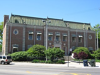
Northside or North Side is a neighborhood in western East Chicago, Indiana. Together with Southside and Roxana, it makes up "East Chicago proper," as distinct from Indiana Harbor. The population is 72% Hispanic and 21% African American. The neighborhood has one of the highest rates of owner-occupied homes in the city. Notable landmarks in Northside include the East Chicago City Hall and Central High School.
Southside or South Side is a neighborhood in western East Chicago, Indiana. Together with Northside and Roxana, it makes up "East Chicago proper," as distinct from Indiana Harbor. The population is 64% Hispanic and 25% African American. The neighborhood is home to 20% of East Chicago's population. The neighborhood is dominated by residential properties, with relatively few institutional buildings.
Washington Park or Park Addition is a neighborhood in the Indiana Harbor section of East Chicago, Indiana, near the city park with which it shares its name. It is bounded on the north by U.S. Route 12, and on the south by 144th Street.
The U.S. Smelting and Lead Refinery Inc. site, commonly known as USS Lead, is a superfund site located in East Chicago, which is located in northwest Indiana. The site includes part of the former USS Lead facility along with nearby commercial, municipal, and residential areas. Originally the site was used as a lead ore refinery with the surrounding businesses at the time performing similar operations. Through a history of redlining and racial discrimination brought on by the 1920 Urban Renewal Campaign, it is seen that East Chicago’s minority community is subject to the consequences of the contamination and has led to claims of environmental racism. The primary contaminants of concern for this area are lead and arsenic, both of which when in the human bloodstream, cause numerous health effects. The site is currently undergoing testing and remediation. This Superfund site is broken down into two Operable Units. The first, OU1, has been divided into three zones, these being the public housing complex and residential properties. OU2 includes soil at the former USS Lead facility, as well as groundwater in and around the site.
The East Phillips Neighborhood Institute (EPNI) is a social movement that was established to identify and highlight pollutant concerns and the risks of proposed construction projects within the East Phillips neighborhood of Minneapolis, Minnesota. The movement was founded in 2014, initially, to address relocation efforts of two factories within the neighborhood that were considered sources of pollution. Upon learning that the city intended to purchase a different site within East Phillips to construct a public works truck facility, EPNI refocused their efforts to stop the construction from occurring.
