East Chicago is a city in Lake County, Indiana, United States. The population was 29,698 at the 2010 census. It is the home of Marktown, Clayton Mark's planned worker community.

East Williamsburg is a name for the area in the northwestern portion of Brooklyn, New York City. East Williamsburg consists roughly of what was the 3rd District of the Village of Williamsburg and what is now called the East Williamsburg In-Place Industrial Park (EWIPIP), bounded by the neighborhoods of Northside and Southside Williamsburg to the west, Greenpoint to the north, Bushwick to the south and southeast, and both Maspeth and Ridgewood in Queens to the east. Much of this area is still referred to as either Bushwick, Williamsburg, or Greenpoint with the term East Williamsburg falling out of use since the 1990s.

The Near South Side is a community area of Chicago, Illinois, United States, just south of the downtown central business district, the Loop. The Near South Side's boundaries are as follows: North—Roosevelt Road ; South—26th Street; West—Chicago River between Roosevelt and 18th Street, Clark Street between 18th Street and Cermak Road, Federal between Cermak Road and the Stevenson Expressway just south of 25th Street, and Clark Street again between the Stevenson and 26th Street; and East—Lake Michigan.
This article is about the many neighborhoods and districts in the Greater Richmond, Virginia area. Note that this article is an attempt to be inclusive of the broader definitions of the areas which are often considered part of the Greater Richmond Region, based on their urban or suburban character and nature, rather than by strictly political boundaries.

Hegewisch is one of the 77 community areas of Chicago, Illinois, located on the city's far south side. It is bordered by the neighborhoods of Riverdale and South Deering to the west, the East Side to the north, the village of Burnham to the south and the city of Hammond, Indiana to the east. The community area is named for Adolph Hegewisch, the president of U.S. Rolling Stock Company who hoped to establish "an ideal workingman's community" when he laid out the town along a rail line in 1883, six years before Chicago annexed the town.

There are more than 500 neighborhoods within the area of Jacksonville, Florida, the largest city in the contiguous United States by area. These include Downtown Jacksonville and surrounding neighborhoods. Additionally, greater Jacksonville is traditionally divided into several major sections with amorphous boundaries: Northside, Westside, Southside, and Arlington, as well as the Jacksonville Beaches.

Westport is a neighborhood in south Baltimore, Maryland. Westport is a majority African-American neighborhood that has struggled with crime, housing abandonment, and unemployment in the past decade. The neighborhood is bordered by the Middle Branch of the Patapsco River on the east, the city neighborhoods of Cherry Hill, Brooklyn and the southwestern Baltimore County community of Lansdowne to the southwest, Hollins Ferry Road and the Mount Winans and Lakeland neighborhoods to the west, and Interstate 95 to the north, along with the South Baltimore communities of Federal Hill and Otterbein. The Baltimore–Washington Parkway runs through the middle of Westport and intersects with Interstate 95, the main East Coast super-highway, north to south, Maine to Florida.
Columbus, the state capital and Ohio's largest city, has numerous neighborhoods within its city limits. Neighborhood names and boundaries are not officially defined. They may vary or change from time to time due to demographic and economic variables.

Fountain Square is one of seven designated cultural districts in Indianapolis, Indiana. Located just outside the city's downtown district, Fountain Square is home to three designated national historic districts, the Laurel and Prospect, the State and Prospect, and the Virginia Avenue districts, all of which were listed on the National Register of Historic Places in 1983. The neighborhood derives its name from the successive fountains that have been prominently featured at the intersection of Virginia Avenue, East Prospect Street, and Shelby Street.
Polish Home Hall is a historic building located in the waterfront industrial/commercial/residential and heavily ethnic community of Curtis Bay in southern Baltimore, Maryland,. Built on the southwest corner of Fairhaven Avenue and Filbert Street near the top of the commanding heights overlooking to the east the sloping streets of the neighborhood of Curtis Bay, about four city blocks wide and 15 blocks length.

Ambridge Mann, sometimes called Ambridge-Horace Mann or Horace Mann-Ambridge, is a neighborhood in northwestern Gary, Indiana. It is bounded by the Grand Calumet River on the north, by Grant Street on the east, by Chase Street on the west, and by the Norfolk Southern railroad on the south. Adjacent areas include an industrial district to the north, Downtown West to the east, Tolleston to the south, and Brunswick to the west. As of 2000, Ambridge Mann had a population of 6,236, which was 96.3% African-American. Located just south of Interstate 90, the neighborhood can be seen while passing Buchanan Street.

Central Hammond is a neighborhood in western Hammond, Indiana, approximately between the Illinois state line and White Oak Avenue, north of 165th Street. It is bounded to the south by South Hammond and Woodmar, to the west by Calumet City, Illinois, to the north by North Hammond, and to the east by the East Chicago neighborhoods of Roxana and Southside. The sinuous Grand Calumet River marks the neighborhood's northern boundary. The neighborhood's boundaries correspond to Hammond's Planning District III.
Roxana, sometimes spelled Roxanna, is a neighborhood in southwestern East Chicago, Indiana, south of the Grand Calumet River and north of Michigan Street. It is the only East Chicago neighborhood located south of the Grand Calumet. As of 2013, it was home to approximately 1032 people, of whom 6.5% were Hispanic and 8% were African American.
New Addition, also called West Harbor, is a small triangular neighborhood in the Indiana Harbor section of East Chicago, Indiana, west of Kennedy Avenue, east of the Indiana Harbor and Ship Canal, and north of United States Route 12. As of 2013, it was home to approximately 263 people.
Calumet is the portion of East Chicago, Indiana located east of the Indiana Harbor and Ship Canal and south of Chicago Avenue. The neighborhood is bisected by the Indiana Harbor Belt Railroad. The area west of the tracks is referred to as Calumet proper, or as "West Calumet". The area east of the tracks is known as "East Calumet."
North Harbor is a neighborhood in northeastern East Chicago, Indiana. It constitutes the portion of the Indiana Harbor section north of 138th Street. The neighborhood is home to one of the highest concentrations of affordable housing in the United States.

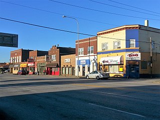
Northside or North Side is a neighborhood in western East Chicago, Indiana. Together with Southside and Roxana, it makes up "East Chicago proper," as distinct from Indiana Harbor. The population is 72% Hispanic and 21% African American. The neighborhood has one of the highest rates of owner-occupied homes in the city. Notable landmarks in Northside include the East Chicago City Hall and Central High School.
Washington Park or Park Addition is a neighborhood in the Indiana Harbor section of East Chicago, Indiana, near the city park with which it shares its name. It is bounded on the north by U.S. Route 12, and on the south by 144th Street.
Prairie Park is a neighborhood in the Indiana Harbor section of East Chicago, Indiana. It is bounded on the north by U.S. 12, and on the south by Indiana 312. To the west, it looks across Elm Street at the Washington Park neighborhood, and to the east it is bounded by the Cline Avenue expressway and industrial northern Gary beyond.
