North Hammond

Last updated
North Hammond
Neighborhood
Coordinates: 41°37′52″N87°30′50″W / 41.63111°N 87.51389°W / 41.63111; -87.51389 Coordinates: 41°37′52″N87°30′50″W / 41.63111°N 87.51389°W / 41.63111; -87.51389
Country Flag of the United States.svg  United States
State Flag of Indiana.svg  Indiana
County Lake County
City Hammond
Time zone CST (UTC-6)
  Summer (DST) CDT (UTC-5)
ZIP code 46320, 46327
Area code(s) 219

North Hammond is a neighborhood in western Hammond, Indiana, north of the Grand Calumet River and south of Wolf Lake. It is bounded to the south by Central Hammond, to the west by the Chicago neighborhood of Hegewisch, to the north by Robertsdale, and to the east by East Chicago. The neighborhood's boundaries correspond to Hammond's Planning District II. [1] The neighborhood is traversed by the Indiana Toll Road, which has an exit into the neighborhood at Calumet Avenue, and by the South Shore Line railroad. Passenger trains for the Northern Indiana Commuter Transportation District stop at Hammond Station in the neighborhood.

Hammond, Indiana City in Indiana, United States

Hammond is a city in Lake County, Indiana, United States. It is part of the Chicago metropolitan area. First settled in the mid-19th century, it is one of the oldest cities of northern Lake County. As of the 2010 United States census, it is also the largest in population: the 2010 population was 80,830, replacing Gary as the most populous city in Lake County. From north to south, Hammond runs from Lake Michigan down to the Little Calumet River; from east to west along its southern border, it runs from the Illinois state line to Cline Avenue. The city is traversed by numerous railroads and expressways, including the South Shore Line, Borman Expressway, and Indiana Toll Road.

Grand Calumet River river in the United States

The Grand Calumet River is a 13.0-mile-long (20.9 km) river that flows primarily into Lake Michigan. Originating in Miller Beach in Gary, it flows through the cities of Gary, East Chicago and Hammond, as well as Calumet City and Burnham on the Illinois side. The majority of the river's flow drains into Lake Michigan via the Indiana Harbor and Ship Canal, sending about 1,500 cubic feet (42 m3) per second of water into the lake. A smaller part of the flow, at the river's western end, enters the Calumet River and ultimately drains into the Illinois and ultimately the Mississippi River.

Wolf Lake (Indiana–Illinois) lake of the United States of America

Wolf Lake is an 804-acre (325.4 ha) lake that straddles the Indiana and Illinois state line near Lake Michigan. It is smaller than it was prior to settlement by people of European descent because of infilling for development around the edges. Despite years of environmental damage caused by heavy industries, transportation infrastructure, urban runoff and filling of wetlands, it is one of the most important biological sites in the Chicago region.

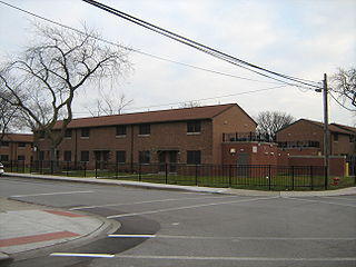
The land area of North Hammond is dominated by industrial land uses. [2] Residential uses are found chiefly south of the Indiana Toll Road. [2] The greatest concentration of commercial activity is along Calumet Avenue, the neighborhood's principal north-south thoroughfare. [2]

North Hammond is sometimes considered to include Robertsdale, thus embracing all of Hammond from the Grand Calumet River to Lake Michigan. [3]

Robertsdale (Hammond) Neighborhood in Lake County, Indiana, United States

Robertsdale is a neighborhood in northernmost Hammond, Indiana, north of 129th Street and south of Lake Michigan. It is bounded to the south by North Hammond, to the west by the Chicago neighborhood of East Side, to the north by Lake Michigan, and to the east by the town of Whiting and the city of East Chicago. The neighborhood's boundaries correspond to Hammond's Planning District I. The neighborhood is traversed by the Indiana Toll Road, which has an exit into the neighborhood at the Indianapolis Boulevard immediately east of the state line. Amtrak passenger trains pass through Hammond/Whiting station in the neighborhood.

Lake Michigan One of the Great Lakes of North America

Lake Michigan is one of the five Great Lakes of North America and the only one located entirely within the United States. The other four Great Lakes are shared by the U.S. and Canada. It is the second-largest of the Great Lakes by volume and the third-largest by surface area, after Lake Superior and Lake Huron. To the east, its basin is conjoined with that of Lake Huron through the wide Straits of Mackinac, giving it the same surface elevation as its easterly counterpart; the two are technically a single lake.

Related Research Articles

Lake County, Indiana County in Indiana, United States

Lake County is a county located in the U.S. state of Indiana. In 2010, its population was 496,005, making it Indiana's second-most populous county. The county seat is Crown Point.

Calumet River river in the United States of America

The Calumet River is a system of heavily industrialized rivers and canals in the region between the neighborhood of South Chicago in Chicago, Illinois, and the city of Gary, Indiana. Historically, the Little Calumet River and the Grand Calumet River were one, the former flowing west from Indiana into Illinois, then turning back east to its mouth at Lake Michigan at Marquette Park in Gary.

East Side, Chicago Community area in Illinois, United States

East Side is one of the 77 official community areas of Chicago, Illinois. It is on the far south side of the city, between the Calumet River and the Illinois-Indiana state line, 13 miles (21 km) south of downtown Chicago. The neighborhood has a park on Lake Michigan, Calumet Park, and a forest, Eggers Grove Forest Preserve. It is served by U.S. Highway 12, U.S. Highway 20, and U.S. Highway 41.

Riverdale, Chicago Community area in Illinois, United States

Riverdale is one of the 77 official community areas of Chicago, Illinois and is located on the city's far southeast side.

The Calumet Region is the geographic area drained by the Grand Calumet River and the Little Calumet River of northeastern Illinois and northwestern Indiana in the United States. It is part of the Great Lakes Basin, which eventually reaches the Atlantic Ocean. It is a sub-region of the greater Northwest Indiana region and the even larger Great Lakes region.

Calumet Park

Calumet Park is a 198-acre (79-hectare) park in Chicago, Illinois. It provides access to Lake Michigan from the East Side neighborhood on the city's Southeast Side. The park contains approximately 0.9 miles (1.5 km) of lake frontage from 95th Street to 102nd Street. The park is listed on the National Register of Historic Places.

Lake Chicago

This article is about the prehistoric lake, For other geographic features with this name, see Chicago

Interstate 94 (I-94) is a part of the Interstate Highway System that runs from Billings, Montana, to Port Huron, Michigan. I-94 enters Indiana from Illinois in the west, in Munster and runs generally eastward through Hammond, Gary and Portage, before entering Michigan northeast of Michigan City. The interstate runs for approximately 45.75 miles (73.63 km) through the state. The landscape traversed by I-94 include urban areas of Northwest Indiana, wooded areas, and farmland. The section of I-94 between the Illinois state line and Lake Station is named the Borman Expressway.

Ambridge Mann Neighborhood in Lake County, Indiana, United States

Ambridge Mann, sometimes called Ambridge-Horace Mann or Horace Mann-Ambridge, is a neighborhood in northwestern Gary, Indiana. It is bounded by the Grand Calumet River on the north, by Grant Street on the east, by Chase Street on the west, and by the Norfolk Southern railroad on the south. Adjacent areas include an industrial district to the north, Downtown West to the east, Tolleston to the south, and Brunswick to the west. As of 2000, Ambridge Mann had a population of 6,236, which was 96.3% African-American. Located just south of Interstate 90, the neighborhood can be seen while passing Buchanan Street.

Brunswick (Gary) Neighborhood in Lake County, Indiana, United States

Brunswick is a neighborhood in northwestern Gary, Indiana, just south of Gary Chicago Airport. It borders Hammond and East Chicago to the west, and the Gary neighborhoods of Ambridge Mann to the east and Westside to the south. The borders are defined by the Indiana Toll Road on the north, Chase Street on the east, the Norfolk Southern railway on the south and Cline Avenue on the west. As of 2000, Brunswick had a population of 4,442 people, which was 84.6% African-American and 7.7% white. Like many Gary neighborhoods, Brunswick was a segregated white community until the early 1970s, when massive white flight occurred.

Emerson (Gary) Neighborhood in Lake County, Indiana, United States

Emerson, also called Downtown East, is a neighborhood in north-central Gary, Indiana. Emerson and Downtown West combine to form what is known as Downtown Gary. It was part of the original plat built by the United States Steel Corporation. Emerson is located east of Broadway, south of the Grand Calumet River, north of Ninth Avenue and west of Interstate 65. As of 2000, it had a population of 3,358. Emerson borders directly on Downtown West to the west but is separated from the Aetna and Pulaski neighborhoods to the east and south by an industrial corridor.

Downtown Gary Neighborhood in Lake County, Indiana, United States

Downtown Gary is split by Broadway into two separate neighborhoods in north-central Gary, Indiana. Emerson and Downtown West combine to form what is known as Downtown Gary. It was part of the original plat built by the United States Steel Corporation. It is located east of Grant Street, south of the Grand Calumet River, north of 9th Avenue and west of Interstate 65. Downtown West borders Ambridge Mann to the west and Midtown to the south, but it is separated from the Aetna and Pulaski neighborhoods to the east and south by an industrial corridor.

South Hammond Neighborhood in Lake County, Indiana, United States

South Hammond is a neighborhood in southwestern Hammond, Indiana, approximately between the Illinois state line and Columbia Avenue, south of 165th Street. It is bounded to the east by Woodmar, to the south by the towns of Munster and Highland, to the west by Calumet City, Illinois, and to the north by Central Hammond. The Little Calumet River snakes along the neighborhood's southern boundary. The neighborhood's boundaries correspond to Hammond's Planning District IV.

Central Hammond Neighborhood in Lake County, Indiana, United States

Central Hammond is a neighborhood in western Hammond, Indiana, approximately between the Illinois state line and White Oak Avenue, north of 165th Street. It is bounded to the south by South Hammond and Woodmar, to the west by Calumet City, Illinois, to the north by North Hammond, and to the east by the East Chicago neighborhoods of Roxana and Southside. The sinuous Grand Calumet River marks the neighborhood's northern boundary. The neighborhood's boundaries correspond to Hammond's Planning District III.

Roxana, sometimes spelled Roxanna, is a neighborhood in southwestern East Chicago, Indiana, south of the Grand Calumet River and north of Michigan Street. It is the only East Chicago neighborhood located south of the Grand Calumet. As of 2013, it was home to approximately 1032 people, of whom 6.5% were Hispanic and 8% were African American.

Calumet is the portion of East Chicago, Indiana located east of the Indiana Harbor and Ship Canal and south of Chicago Avenue. The neighborhood is bisected by the Indiana Harbor Belt Railroad. The area west of the tracks is referred to as Calumet proper, or as "West Calumet". The area east of the tracks is known as "East Calumet."

Southside (East Chicago) Neighborhood in Lake County, Indiana, United States

Southside or South Side is a neighborhood in western East Chicago, Indiana. Together with Northside and Roxana, it makes up "East Chicago proper," as distinct from Indiana Harbor. The population is 64% Hispanic and 25% African American. The neighborhood is home to 20% of East Chicago's population. The neighborhood is dominated by residential uses, with relatively few institutional buildings.

References