Central Hammond

Last updated
Central Hammond
Neighborhood
Coordinates: 41°37′02″N87°31′26″W / 41.61722°N 87.52389°W / 41.61722; -87.52389 Coordinates: 41°37′02″N87°31′26″W / 41.61722°N 87.52389°W / 41.61722; -87.52389
Country Flag of the United States.svg  United States
State Flag of Indiana.svg  Indiana
County Lake County
City Hammond
Time zone CST (UTC-6)
  Summer (DST) CDT (UTC-5)
ZIP code 46320
Area code(s) 219

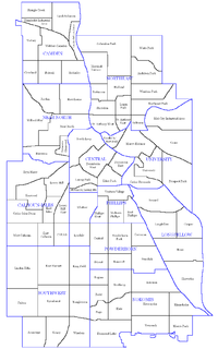
Central Hammond is a neighborhood in western Hammond, Indiana, approximately between the Illinois state line and White Oak Avenue, north of 165th Street. It is bounded to the south by South Hammond and Woodmar, to the west by Calumet City, Illinois, to the north by North Hammond, and to the east by the East Chicago neighborhoods of Roxana and Southside. The sinuous Grand Calumet River marks the neighborhood's northern boundary. [1] The neighborhood's boundaries correspond to Hammond's Planning District III. [2]

Hammond, Indiana City in Indiana, United States

Hammond is a city in Lake County, Indiana, United States. It is part of the Chicago metropolitan area. First settled in the mid-19th century, it is one of the oldest cities of northern Lake County. As of the 2010 United States census, it is also the largest in population: the 2010 population was 80,830, replacing Gary as the most populous city in Lake County. From north to south, Hammond runs from Lake Michigan down to the Little Calumet River; from east to west along its southern border, it runs from the Illinois state line to Cline Avenue. The city is traversed by numerous railroads and expressways, including the South Shore Line, Borman Expressway, and Indiana Toll Road.

Illinois State of the United States of America

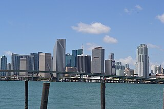
Illinois is a state in the Midwestern region of the United States. It has the 5th largest Gross Domestic Product by state, is the 6th-most populous U.S. state and 25th-largest state in terms of land area. Illinois is often noted as a microcosm of the entire United States. With Chicago in the northeast, small industrial cities and great agricultural productivity in northern and central Illinois, and natural resources such as coal, timber, and petroleum in the south, Illinois has a diverse economic base, and is a major transportation hub. Chicagoland, Chicago's metropolitan area, contains over 65% of the state's population. The Port of Chicago connects the state to other global ports around the world from the Great Lakes, via the Saint Lawrence Seaway, to the Atlantic Ocean; as well as the Great Lakes to the Mississippi River, via the Illinois Waterway on the Illinois River. The Mississippi River, the Ohio River, and the Wabash River form parts of the boundaries of Illinois. For decades, Chicago's O'Hare International Airport has been ranked as one of the world's busiest airports. Illinois has long had a reputation as a bellwether both in social and cultural terms and, through the 1980s, in politics.

South Hammond Neighborhood in Lake County, Indiana, United States

South Hammond is a neighborhood in southwestern Hammond, Indiana, approximately between the Illinois state line and Columbia Avenue, south of 165th Street. It is bounded to the east by Woodmar, to the south by the towns of Munster and Highland, to the west by Calumet City, Illinois, and to the north by Central Hammond. The Little Calumet River snakes along the neighborhood's southern boundary. The neighborhood's boundaries correspond to Hammond's Planning District IV.

A storefront in Central Hammond Hammond, IN, USA - panoramio (2).jpg
A storefront in Central Hammond

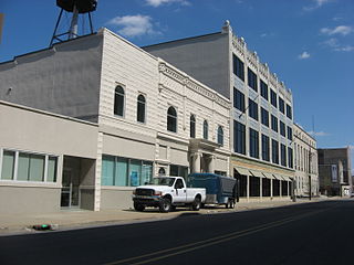
Central Hammond is made up of a patchwork of residential, commercial and institutional land uses. [1] The neighborhood includes Hammond's historic downtown, home of the State Street Commercial Historic District and Hohman Avenue Commercial Historic District, as well as the Hammond federal courthouse for the United States District Court for the Northern District of Indiana. Beyond the downtown, the neighborhood is also contains the Forest–Moraine Residential Historic District in its southwestern corner.

State Street Commercial Historic District

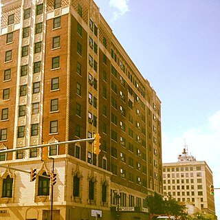
State Street Commercial Historic District is a national historic district located at Hammond, Lake County, Indiana. The district encompasses 28 contributing buildings in the central business district of Hammond. It developed between about 1885 and 1946, and includes notable example of Commercial, Classical Revival, Late Gothic Revival, and Art Deco style architecture. Notable buildings include the L. Fish Building (1927), Federal Building (1939), Lincoln Hotel (1923), Seifer Building (1925), and the Henderson Building (1902).

Hohman Avenue Commercial Historic District

Hohman Avenue Commercial Historic District is a national historic district located at Hammond, Lake County, Indiana. The district encompasses 15 contributing buildings in the central business district of Hammond. It developed between about 1904 and 1956, and includes notable example of Romanesque Revival, Classical Revival, and Colonial Revival style architecture. Notable buildings include Knott's Apartments (1904), Emmerling Ambulance Garage (1918), Emmerling Building (1918), St. Joseph's Roman Catholic Church Complex, LaSalle Hotel, OK Building (1913), and the Hammond National Bank.

United States District Court for the Northern District of Indiana

The U.S. District Court for the Northern District of Indiana was created in 1928 by an act of Congress that split Indiana into two separate districts, northern and southern. As part of the act, the Northern District was divided into three divisions, South Bend, Fort Wayne, and Hammond. Appeals from this court are taken to the United States Court of Appeals for the Seventh Circuit. The court has eight judges and four magistrate judges.

Related Research Articles

Gary, Indiana City in Indiana, United States

Gary is a city in Lake County, Indiana, United States, 25 miles (40 km) from downtown Chicago, Illinois. Gary is adjacent to the Indiana Dunes National Park and borders southern Lake Michigan. Gary was named after lawyer Elbert Henry Gary, who was the founding chairman of the United States Steel Corporation. The city is known for its large steel mills, and as the birthplace of the Jackson 5 music group.

Near South Side, Chicago Community area in Illinois, United States

The Near South Side is a community area of Chicago, Illinois, United States, just south of the downtown central business district, the Loop. The Near South Side's boundaries are as follows: North—Roosevelt Road ; South—26th Street; West—Chicago River between Roosevelt and 18th Street, Clark Street between 18th Street and Cermak Road, Federal between Cermak Road and the Stevenson Expressway just south of 25th Street, and Clark Street again between the Stevenson and 26th Street; and East—Lake Michigan.

Neighborhoods of Minneapolis One of the 81 official neighborhoods of Minneapolis

The city of Minneapolis, Minnesota is officially defined by the Minneapolis City Council as divided into eleven communities, each containing multiple official neighborhoods. Informally, there are city areas with colloquial labels. Residents may also group themselves by their city street suffixes, North, Northeast, South, Southeast, and Southwest.

East Side, Chicago Community area in Illinois, United States

East Side is one of the 77 official community areas of Chicago, Illinois. It is on the far south side of the city, between the Calumet River and the Illinois-Indiana state line, 13 miles (21 km) south of downtown Chicago. The neighborhood has a park on Lake Michigan, Calumet Park, and a forest, Eggers Grove Forest Preserve. It is served by U.S. Highway 12, U.S. Highway 20, and U.S. Highway 41.

Midtown Memphis, Tennessee is a collection of neighborhoods to the east of Downtown.

Downtown Jacksonville A neighborhood of Jacksonville, Florida

Downtown Jacksonville is the historic core and central business district (CBD) of Jacksonville, Florida USA. It comprises the earliest area of the city to be developed and is located in its geographic center along the narrowing point of the St. Johns River. There are various definitions of what constitutes Jacksonville's downtown; the one used by the city government and other entities defines it as including five districts: the Downtown Core, the Southbank, LaVilla, Brooklyn, and the Sports Complex. The area features offices for major corporations such as CSX Corporation, Fidelity National Financial, TIAA Bank, Bank of America, Prudential Financial, Wells Fargo, AT&T, and Aetna.

Greater Downtown Miami Neighborhood of Miami in Miami-Dade County, Florida, United States

Downtown Miami is an urban city center, based around the Central Business District of Miami, Florida, United States. In addition to the central business district, the area also consists of the Brickell Financial District, Historic District, Government Center, Arts & Entertainment District and Park West. The neighborhood is divided by the Miami River and is bordered by Midtown to the north, Biscayne Bay to the east, Civic Center and Overtown to the west, and Coconut Grove to the south.

Columbus, Ohio does not have defined neighborhoods, per the city of Columbus, making their areas difficult to define. Neighborhoods often overlap and vary in size. Many of Columbus's larger neighborhoods integrate smaller neighborhoods. Additionally, modern interpretations of neighborhood borders vary significantly as historical neighborhoods, villages, towns and townships have been annexed and absorbed by the city of Columbus. There are Area Commissions that exist, but these generally are larger than neighborhoods themselves and typically incorporate smaller neighborhoods.

Neighborhoods of Albany, New York

The neighborhoods of Albany, New York are varied demographically, geographically, architecturally, and historically. Downtown Albany is the city's oldest neighborhood, centered on State Street, one of Albany's oldest streets and its original main street. North and south of Downtown Albany are old residential communities often consisting of row houses; to the north, those neighborhoods include Sheridan Hollow, Arbor Hill, and North Albany, while to the south is the super-neighborhood of the South End, which includes several smaller neighborhoods.

Meridian Street is the primary north-south street in Indianapolis, Indiana, United States.

Downtown Gary Neighborhood in Lake County, Indiana, United States

Downtown Gary is split by Broadway into two separate neighborhoods in north-central Gary, Indiana. Emerson and Downtown West combine to form what is known as Downtown Gary. It was part of the original plat built by the United States Steel Corporation. It is located east of Grant Street, south of the Grand Calumet River, north of 9th Avenue and west of Interstate 65. Downtown West borders Ambridge Mann to the west and Midtown to the south, but it is separated from the Aetna and Pulaski neighborhoods to the east and south by an industrial corridor.

Woodmar (Hammond) Neighborhood in Lake County, Indiana, United States

Woodmar is a neighborhood in southeast Hammond, Indiana, approximately between Columbia and Kennedy Avenues. It is bounded to the east by Hessville, to the west by South Hammond, to the north by industrial land along United States Route 20, and to the south by the town of Highland. The neighborhood's boundaries correspond to Hammond's Planning District V.

North Hammond is a neighborhood in western Hammond, Indiana, north of the Grand Calumet River and south of Wolf Lake. It is bounded to the south by Central Hammond, to the west by the Chicago neighborhood of Hegewisch, to the north by Robertsdale, and to the east by East Chicago. The neighborhood's boundaries correspond to Hammond's Planning District II. The neighborhood is traversed by the Indiana Toll Road, which has an exit into the neighborhood at Calumet Avenue, and by the South Shore Line railroad. Passenger trains for the Northern Indiana Commuter Transportation District stop at Hammond Station in the neighborhood.

Robertsdale (Hammond) Neighborhood in Lake County, Indiana, United States

Robertsdale is a neighborhood in northernmost Hammond, Indiana, north of 129th Street and south of Lake Michigan. It is bounded to the south by North Hammond, to the west by the Chicago neighborhood of East Side, to the north by Lake Michigan, and to the east by the town of Whiting and the city of East Chicago. The neighborhood's boundaries correspond to Hammond's Planning District I. The neighborhood is traversed by the Indiana Toll Road, which has an exit into the neighborhood at the Indianapolis Boulevard immediately east of the state line. Amtrak passenger trains pass through Hammond/Whiting station in the neighborhood.

Calumet is the portion of East Chicago, Indiana located east of the Indiana Harbor and Ship Canal and south of Chicago Avenue. The neighborhood is bisected by the Indiana Harbor Belt Railroad. The area west of the tracks is referred to as Calumet proper, or as "West Calumet". The area east of the tracks is known as "East Calumet."

Southside (East Chicago) Neighborhood in Lake County, Indiana, United States

Southside or South Side is a neighborhood in western East Chicago, Indiana. Together with Northside and Roxana, it makes up "East Chicago proper," as distinct from Indiana Harbor. The population is 64% Hispanic and 25% African American. The neighborhood is home to 20% of East Chicago's population. The neighborhood is dominated by residential uses, with relatively few institutional buildings.

McAdams, Wichita, Kansas Neighborhood in Sedgwick, Kansas, United States

McAdams is a neighborhood in Wichita, Kansas, United States. A mixed industrial and residential area northeast of Downtown Wichita, it is a historical center of the city’s African American community.

References