South Hammond

Last updated
South Hammond
Neighborhood
Coordinates: 41°35′06″N87°31′26″W / 41.58500°N 87.52389°W / 41.58500; -87.52389 Coordinates: 41°35′06″N87°31′26″W / 41.58500°N 87.52389°W / 41.58500; -87.52389
Country Flag of the United States.svg  United States
State Flag of Indiana.svg  Indiana
County Lake County
City Hammond
Time zone CST (UTC-6)
  Summer (DST) CDT (UTC-5)
ZIP code 46324
Area code(s) 219

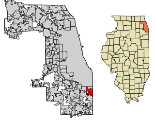
South Hammond is a neighborhood in southwestern Hammond, Indiana, approximately between the Illinois state line and Columbia Avenue, south of 165th Street. It is bounded to the east by Woodmar, to the south by the towns of Munster and Highland, to the west by Calumet City, Illinois, and to the north by Central Hammond. [1] The Little Calumet River snakes along the neighborhood's southern boundary. The neighborhood's boundaries correspond to Hammond's Planning District IV. [1]

Hammond, Indiana City in Indiana, United States

Hammond is a city in Lake County, Indiana, United States. It is part of the Chicago metropolitan area. First settled in the mid-19th century, it is one of the oldest cities of northern Lake County. As of the 2010 United States census, it is also the largest in population: the 2010 population was 80,830, replacing Gary as the most populous city in Lake County. From north to south, Hammond runs from Lake Michigan down to the Little Calumet River; from east to west along its southern border, it runs from the Illinois state line to Cline Avenue. The city is traversed by numerous railroads and expressways, including the South Shore Line, Borman Expressway, and Indiana Toll Road.

Illinois State of the United States of America

Illinois is a state in the Midwestern region of the United States. It has the 5th largest Gross Domestic Product by state, is the 6th-most populous U.S. state and 25th-largest state in terms of land area. Illinois is often noted as a microcosm of the entire United States. With Chicago in the northeast, small industrial cities and great agricultural productivity in northern and central Illinois, and natural resources such as coal, timber, and petroleum in the south, Illinois has a diverse economic base, and is a major transportation hub. Chicagoland, Chicago's metropolitan area, contains over 65% of the state's population. The Port of Chicago connects the state to other global ports around the world from the Great Lakes, via the Saint Lawrence Seaway, to the Atlantic Ocean; as well as the Great Lakes to the Mississippi River, via the Illinois Waterway on the Illinois River. The Mississippi River, the Ohio River, and the Wabash River form parts of the boundaries of Illinois. For decades, Chicago's O'Hare International Airport has been ranked as one of the world's busiest airports. Illinois has long had a reputation as a bellwether both in social and cultural terms and, through the 1980s, in politics.

Woodmar (Hammond) Neighborhood in Lake County, Indiana, United States

Woodmar is a neighborhood in southeast Hammond, Indiana, approximately between Columbia and Kennedy Avenues. It is bounded to the east by Hessville, to the west by South Hammond, to the north by industrial land along United States Route 20, and to the south by the town of Highland. The neighborhood's boundaries correspond to Hammond's Planning District V.

Home in the Indi-Illi Park Historic District in South Hammond. Indi-Illi Park Historic District.jpg
Home in the Indi-Illi Park Historic District in South Hammond.

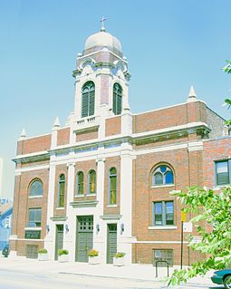
With the exception of a commercial strip along Calumet Avenue, South Hammond is overwhelmingly residential. [2] Many of these residences are historic: South Hammond is home to the Indi-Illi Park Historic District, Roselawn–Forest Heights Historic District and Forest–Ivanhoe Residential Historic District.

Indi-Illi Park Historic District

Indi-Illi Park Historic District is a national historic district located at Hammond, Lake County, Indiana. The district encompasses 93 contributing buildings in an exclusively residential section of Hammond. It developed between about 1923 and 1940, and includes notable example of Colonial Revival, Tudor Revival, Classical Revival, Bungalow / American Craftsman, and eclectic styles of residential architecture.

Roselawn–Forest Heights Historic District

Roselawn–Forest Heights Historic District is a national historic district located at Hammond, Lake County, Indiana. The district encompasses 107 contributing buildings in a predominantly residential section of Hammond. It developed between about 1922 and 1962, and includes notable example of Colonial Revival, Tudor Revival, Bungalow / American Craftsman, and American Small House and eclectic styles of residential architecture. Located in the district is the separately listed George John Wolf House.

Forest–Ivanhoe Residential Historic District

Forest–Ivanhoe Residential Historic District is a national historic district located at Hammond, Lake County, Indiana. The district encompasses 25 contributing buildings in an exclusively residential section of Hammond. It developed between about 1925 and 1952, and includes notable example of Colonial Revival, Tudor Revival, and English Cottage style residential architecture. Most of the residences have attached garages.

Related Research Articles

Calumet City, Illinois City in Illinois, United States

Calumet City is a city in Cook County, Illinois, United States. The population was 37,042 at the 2010 census, a decline of 5.2% from 2000. The ZIP code is 60409.

Calumet River river in the United States of America

The Calumet River is a system of heavily industrialized rivers and canals in the region between the neighborhood of South Chicago in Chicago, Illinois, and the city of Gary, Indiana. Historically, the Little Calumet River and the Grand Calumet River were one, the former flowing west from Indiana into Illinois, then turning back east to its mouth at Lake Michigan at Marquette Park in Gary.

Near South Side, Chicago Community area in Illinois, United States

The Near South Side is a community area of Chicago, Illinois, United States, just south of the downtown central business district, the Loop. The Near South Side's boundaries are as follows: North—Roosevelt Road ; South—26th Street; West—Chicago River between Roosevelt and 18th Street, Clark Street between 18th Street and Cermak Road, Federal between Cermak Road and the Stevenson Expressway just south of 25th Street, and Clark Street again between the Stevenson and 26th Street; and East—Lake Michigan.

Westville, New Haven Neighborhood of New Haven in Connecticut, United States

Westville is a neighborhood of the city of New Haven, Connecticut. It is consistently ranked as one of the best neighborhoods to live in New Haven due to its high home values, low crime rates, walkable streets, proximity to downtown, and local amenities.

South Chicago, Chicago Community area in Illinois, United States

South Chicago, formerly known as Ainsworth, is one of the 77 well-defined community areas of Chicago, Illinois.

This article is about the many neighborhoods and districts in the Greater Richmond, Virginia area. Note that this article is an attempt to be inclusive of the broader definitions of the areas which are often considered part of the Greater Richmond Region, based on their urban or suburban character and nature, rather than by strictly political boundaries.

East Side, Chicago Community area in Illinois, United States

East Side is one of the 77 official community areas of Chicago, Illinois. It is on the far south side of the city, between the Calumet River and the Illinois-Indiana state line, 13 miles (21 km) south of downtown Chicago. The neighborhood has a park on Lake Michigan, Calumet Park, and a forest, Eggers Grove Forest Preserve. It is served by U.S. Highway 12, U.S. Highway 20, and U.S. Highway 41.

West Canfield Historic District human settlement in United States of America

The West Canfield Historic District is a neighborhood historic district located primarily on Canfield Avenue between Second and Third Streets in Detroit, Michigan. A boundary increase enlarged the district to include buildings on Third Avenue between Canfield and Calumet. The district was designated a Michigan State Historic Site in 1970 and listed on the National Register of Historic Places in 1971; a boundary increase was added in 1997. The revitalized 1870s era neighborhood is one of the residential areas surrounding the city's Cultural Center Historic District in Midtown. Nearby, East Canfield Avenue leads to the Detroit Medical Center complex, the Romanesque Revival styled St. Josaphat's Catholic Church, and the Gothic revival styled Sweetest Heart of Mary Catholic Church.

Prairie District Neighborhood Alliance organization

The Prairie District Neighborhood Alliance (PDNA) is a non-profit resident organization in the South Loop community of Chicago, Illinois. The PDNA, founded in 2006, has grown to provide support and representation to thousands of residents living in and around the Prairie Avenue Historic District, Central Station and Museum Park, south Michigan Avenue corridor, and the broader South Loop. An area regarded as the fastest growing neighborhood in Chicago and one of the hottest neighborhoods in the country. Basic Members receive free email updates and newsletters on community events; development news; educational, historical and cultural programs; select surveys and other important community news and information. The PDNA provides additional membership programs offering support and benefits to residents, condominium/townhome associations, businesses, cultural institutions and organizations who reside within the Organization's boundaries and who agrees to and supports the purpose of the Alliance.

Prairie Avenue thoroughfare in Chicago, United States

Prairie Avenue is a north–south street on the South Side of Chicago, which historically extended from 16th Street in the Near South Side community area of Chicago in Cook County, Illinois, United States, to the city's southern limits and beyond. The street has a rich history from its origins as a major trail for horseback riders and carriages. During the last three decades of the 19th century, a six-block section of the street served as the residence of many of Chicago's elite families and an additional four-block section was also known for grand homes. The upper six-block section includes part of the historic Prairie Avenue District, which was declared a Chicago Landmark and added to the National Register of Historic Places.

Black Oak (Gary) Neighborhood in Lake County, Indiana, United States

Black Oak is a neighborhood located on the far southwest side of Gary, Indiana. As of 2000, Black Oak had a population of 4,216, which was 84.7% white. It is Gary's only majority-white neighborhood, and the most recent neighborhood added to the city. Black Oak was annexed in 1976, under the administration of mayor Richard Hatcher. Prior to that, Black Oak had been an unincorporated area informally associated with nearby Hammond, and the area has Hammond telephone numbers.

Central Hammond Neighborhood in Lake County, Indiana, United States

Central Hammond is a neighborhood in western Hammond, Indiana, approximately between the Illinois state line and White Oak Avenue, north of 165th Street. It is bounded to the south by South Hammond and Woodmar, to the west by Calumet City, Illinois, to the north by North Hammond, and to the east by the East Chicago neighborhoods of Roxana and Southside. The sinuous Grand Calumet River marks the neighborhood's northern boundary. The neighborhood's boundaries correspond to Hammond's Planning District III.

North Hammond is a neighborhood in western Hammond, Indiana, north of the Grand Calumet River and south of Wolf Lake. It is bounded to the south by Central Hammond, to the west by the Chicago neighborhood of Hegewisch, to the north by Robertsdale, and to the east by East Chicago. The neighborhood's boundaries correspond to Hammond's Planning District II. The neighborhood is traversed by the Indiana Toll Road, which has an exit into the neighborhood at Calumet Avenue, and by the South Shore Line railroad. Passenger trains for the Northern Indiana Commuter Transportation District stop at Hammond Station in the neighborhood.

Robertsdale (Hammond) Neighborhood in Lake County, Indiana, United States

Robertsdale is a neighborhood in northernmost Hammond, Indiana, north of 129th Street and south of Lake Michigan. It is bounded to the south by North Hammond, to the west by the Chicago neighborhood of East Side, to the north by Lake Michigan, and to the east by the town of Whiting and the city of East Chicago. The neighborhood's boundaries correspond to Hammond's Planning District I. The neighborhood is traversed by the Indiana Toll Road, which has an exit into the neighborhood at the Indianapolis Boulevard immediately east of the state line. Amtrak passenger trains pass through Hammond/Whiting station in the neighborhood.

Calumet is the portion of East Chicago, Indiana located east of the Indiana Harbor and Ship Canal and south of Chicago Avenue. The neighborhood is bisected by the Indiana Harbor Belt Railroad. The area west of the tracks is referred to as Calumet proper, or as "West Calumet". The area east of the tracks is known as "East Calumet."

Southside (East Chicago) Neighborhood in Lake County, Indiana, United States

Southside or South Side is a neighborhood in western East Chicago, Indiana. Together with Northside and Roxana, it makes up "East Chicago proper," as distinct from Indiana Harbor. The population is 64% Hispanic and 25% African American. The neighborhood is home to 20% of East Chicago's population. The neighborhood is dominated by residential uses, with relatively few institutional buildings.

References