Woodmar | |
---|---|
Neighborhood | |
Coordinates: 41°35′06″N87°29′25″W / 41.58500°N 87.49028°W Coordinates: 41°35′06″N87°29′25″W / 41.58500°N 87.49028°W | |
Country | |
State | |
County | Lake County |
City | Hammond |
Elevation | 184 m (604 ft) |
Time zone | UTC-6 (CST) |
• Summer (DST) | UTC-5 (CDT) |
ZIP code | 46323, 46324 |
Area code(s) | 219 |
Woodmar is a neighborhood in southeast Hammond, Indiana, approximately between Columbia and Kennedy Avenues. It is bounded to the east by Hessville, to the west by South Hammond, to the north by industrial land along United States Route 20, and to the south by the town of Highland. [2] The neighborhood's boundaries correspond to Hammond's Planning District V. [2]
Hammond is a city in Lake County, Indiana, United States. It is part of the Chicago metropolitan area. First settled in the mid-19th century, it is one of the oldest cities of northern Lake County. As of the 2010 United States census, it is also the largest in population: the 2010 population was 80,830, replacing Gary as the most populous city in Lake County. From north to south, Hammond runs from Lake Michigan down to the Little Calumet River; from east to west along its southern border, it runs from the Illinois state line to Cline Avenue. The city is traversed by numerous railroads and expressways, including the South Shore Line, Borman Expressway, and Indiana Toll Road.
Hessville is a neighborhood of Hammond, Indiana. Located in the southeast corner of Hammond, it adjoins the Hammond neighborhood of Woodmar to the west, the East Chicago neighborhood of Calumet to the north, the Gary neighborhoods of Westside and Black Oak to the east, and the town of Highland to the south.
South Hammond is a neighborhood in southwestern Hammond, Indiana, approximately between the Illinois state line and Columbia Avenue, south of 165th Street. It is bounded to the east by Woodmar, to the south by the towns of Munster and Highland, to the west by Calumet City, Illinois, and to the north by Central Hammond. The Little Calumet River snakes along the neighborhood's southern boundary. The neighborhood's boundaries correspond to Hammond's Planning District IV.
Dominated by large single-family homes, Woodmar was largely built in the 1920s, with the goal of allowing the Calumet Region's wealthier residents to get "out of the smoke zone and into the ozone." [3] In these early years, Woodmar was considered more exclusive than most Hammond neighborhoods. [3]
The Calumet Region is the geographic area drained by the Grand Calumet River and the Little Calumet River of northeastern Illinois and northwestern Indiana in the United States. It is part of the Great Lakes Basin, which eventually reaches the Atlantic Ocean. It is a sub-region of the greater Northwest Indiana region and the even larger Great Lakes region.
Woodmar was formerly home to the Woodmar Mall. It is also home to the Hammond campus of Purdue University Northwest, formerly an independent institution known as Purdue University Calumet. Historic residences in the neighborhood include the Morse Dell Plain House and Garden.
Woodmar Mall was an indoor shopping mall located at Indianapolis Boulevard between 165th Street and 167th Street in Hammond, Indiana. It opened in 1954 and was anchored by Carson Pirie Scott and Co. The mall was closed and demolished in 2006.
Purdue University Northwest (PNW) is a public university with two campuses in Northwest Indiana, one in Hammond and one in Westville. It is part of the Purdue University system and offers more than 70 undergraduate and graduate degree programs to approximately 9,400 students with more than 64,000 alumni.
Morse Dell Plain House and Garden, also known as Woodmar, is a historic home located at 7109 Knickerbocker Parkway in Hammond, Lake County, Indiana. The house was designed by noted Chicago architect Howard Van Doren Shaw and built in 1923. It is a large two-story, Tudor Revival style brick dwelling with a 1 1/2-story service wing. The landscape was designed by Jens Jensen in 1926.
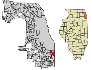
Calumet City is a city in Cook County, Illinois, United States. The population was 37,042 at the 2010 census, a decline of 5.2% from 2000. The ZIP code is 60409.
The Calumet River is a system of heavily industrialized rivers and canals in the region between the neighborhood of South Chicago in Chicago, Illinois, and the city of Gary, Indiana. Historically, the Little Calumet River and the Grand Calumet River were one, the former flowing west from Indiana into Illinois, then turning back east to its mouth at Lake Michigan at Marquette Park in Gary.
East Side is one of the 77 official community areas of Chicago, Illinois. It is on the far south side of the city, between the Calumet River and the Illinois-Indiana state line, 13 miles (21 km) south of downtown Chicago. The neighborhood has a park on Lake Michigan, Calumet Park, and a forest, Eggers Grove Forest Preserve. It is served by U.S. Highway 12, U.S. Highway 20, and U.S. Highway 41.
Thomas Matthew McDermott Jr. is the 20th mayor of Hammond, Indiana, the fifth largest city in Indiana as of the 2010 United States census. He took office on January 1, 2004, the first elected government office he has held. He is a member of the Democratic Party. After winning the general election in November 2015 for an unprecedented fourth term, McDermott became the longest-serving mayor in Hammond's history.
Purdue University is a public university system in the U.S. state of Indiana. A land-grant university with nearly 75,000 students across four traditional campuses, a statewide technology program, extension centers and continuing education programs, as well as another 30,000 students enrolled in an online university. Each university in the system maintains its own faculty and admissions policies which are overseen by the Purdue University Board of Trustees. Purdue's main campus in West Lafayette is the most well-known, noted for its engineering, agriculture, and business administration programs, which consistently rank among the best in the country and the world.
Northwest Indiana comprises Lake, Porter, LaPorte, Newton and Jasper counties in Indiana. This region neighbors Lake Michigan and is part of the Chicago metropolitan area. According to the 2010 Census, Northwest Indiana has a population of 819,537 and is the state's second largest urban area after the Indianapolis Metropolitan Area. It is also the home of the Indiana Dunes, parts of which have been preserved through conservation efforts. The town of Ogden Dunes houses the Hour Glass, a museum showcasing the ecological and conservation efforts of O. D. Frank.
WJOB is a news/talk formatted radio station in Hammond, Indiana. The present tower of the station is 406 feet tall and the station is a 24-hour operation broadcasting with 1,000 Watts of power.
Hammond Transit System was the provider of bus service in the Chicago suburb of Hammond, Indiana. It featured four local intra-city routes and one route that provides access to neighboring Whiting and Chicago's East Side neighborhood. The system was established in 1976 as replacement for the discontinued bus service provided by Chicago & Calumet District Transit Co. The service was a division of the Hammond city government. As of January 1, 2010, the system is operated by the Northwest Indiana Regional Bus Authority. Hammond Transit Center acts as a transit hub, linking together all system routes, as well as Pace suburban bus system, East Chicago Transit and Gary Public Transportation Corporation bus routes.
Black Oak is a neighborhood located on the far southwest side of Gary, Indiana. As of 2000, Black Oak had a population of 4,216, which was 84.7% white. It is Gary's only majority-white neighborhood, and the most recent neighborhood added to the city. Black Oak was annexed in 1976, under the administration of mayor Richard Hatcher. Prior to that, Black Oak had been an unincorporated area informally associated with nearby Hammond, and the area has Hammond telephone numbers.
Brunswick is a neighborhood in northwestern Gary, Indiana, just south of Gary Chicago Airport. It borders Hammond and East Chicago to the west, and the Gary neighborhoods of Ambridge Mann to the east and Westside to the south. The borders are defined by the Indiana Toll Road on the north, Chase Street on the east, the Norfolk Southern railway on the south and Cline Avenue on the west. As of 2000, Brunswick had a population of 4,442 people, which was 84.6% African-American and 7.7% white. Like many Gary neighborhoods, Brunswick was a segregated white community until the early 1970s, when massive white flight occurred.
Calumet High School–Perspectives is a public 4–year charter high school and middle school located in the Auburn Gresham neighborhood on the south side of Chicago, Illinois, United States. Opening as Calumet High School, a neighborhood high school in 1909, closing in 2006. The Calumet school building is now used by two charter schools operated by the Chicago Public Schools system.
Central Hammond is a neighborhood in western Hammond, Indiana, approximately between the Illinois state line and White Oak Avenue, north of 165th Street. It is bounded to the south by South Hammond and Woodmar, to the west by Calumet City, Illinois, to the north by North Hammond, and to the east by the East Chicago neighborhoods of Roxana and Southside. The sinuous Grand Calumet River marks the neighborhood's northern boundary. The neighborhood's boundaries correspond to Hammond's Planning District III.
North Hammond is a neighborhood in western Hammond, Indiana, north of the Grand Calumet River and south of Wolf Lake. It is bounded to the south by Central Hammond, to the west by the Chicago neighborhood of Hegewisch, to the north by Robertsdale, and to the east by East Chicago. The neighborhood's boundaries correspond to Hammond's Planning District II. The neighborhood is traversed by the Indiana Toll Road, which has an exit into the neighborhood at Calumet Avenue, and by the South Shore Line railroad. Passenger trains for the Northern Indiana Commuter Transportation District stop at Hammond Station in the neighborhood.
Roxana, sometimes spelled Roxanna, is a neighborhood in southwestern East Chicago, Indiana, south of the Grand Calumet River and north of Michigan Street. It is the only East Chicago neighborhood located south of the Grand Calumet. As of 2013, it was home to approximately 1032 people, of whom 6.5% were Hispanic and 8% were African American.
Calumet is the portion of East Chicago, Indiana located east of the Indiana Harbor and Ship Canal and south of Chicago Avenue. The neighborhood is bisected by the Indiana Harbor Belt Railroad. The area west of the tracks is referred to as Calumet proper, or as "West Calumet". The area east of the tracks is known as "East Calumet."