Burnley is a town and the administrative centre of the wider Borough of Burnley in Lancashire, England, with a 2001 population of 73,021. It is 21 miles (34 km) north of Manchester and 20 miles (32 km) east of Preston, at the confluence of the River Calder and River Brun.

Barnoldswick is a market town and civil parish in the Borough of Pendle, in the administrative county of Lancashire, England. It is within the boundaries of the historic West Riding of Yorkshire. Barnoldswick and the surrounding areas of West Craven have been administered since 1974 as part of the modern administrative county of Lancashire. This was when West Riding County Council and Barnoldswick Urban District Council were abolished and the town was transferred to the Borough of Pendle.
Reedley Hallows or Reedley is a civil parish in the Borough of Pendle in Lancashire, England. It forms part of Burnley and Brierfield. It had a population of 1,994, reducing to 1,960 at the 2011 Census.
Padiham is a town and civil parish on the River Calder, about three miles (5 km) west of Burnley, Lancashire, England. It forms part of the Borough of Burnley. Originally by the River Calder, it is edged by the foothills of Pendle Hill to the north-west and north-east. The United Kingdom Census 2011 gave a parish population of 10,098, estimated in 2019 at 10,138.

The Borough of Burnley is a local government district with the borough status in Lancashire, England. It has an area of 42.7 square miles (110.7 km2) and a population of 94,721 (2021), and is named after its largest town, Burnley. The borough also contains the town of Padiham along with several villages and surrounding rural areas.

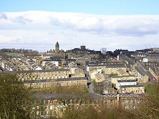
Brierfield is a town and civil parish in the Borough of Pendle, in Lancashire, England. It is 3 miles (4.8 km) north east of Burnley, 1 mile (1.6 km) south west of Nelson, and 1 mile (1.6 km) north east of Reedley. The parish had a population of 8,193, at the census of 2011.
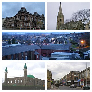
Nelson is a town and civil parish in the Borough of Pendle in Lancashire, England, with a population of 29,135 in 2011. It is 4 miles (6.4 km) north of Burnley and 3 miles south-west of Colne.
Colne is a market town and civil parish in the Borough of Pendle in Lancashire, England. Located three miles northeast of Nelson, six miles northeast of Burnley, 25 mi (40 km) east of Preston and 30 mi (50 km) west of Leeds.
Trawden is a village in the Trawden Forest parish of Pendle, at the foot of Boulsworth Hill, in Lancashire, England. The village co-operatively owns and runs its library, shop, community centre and pub.

Foulridge is a village and civil parish in Pendle, Lancashire, close to the border with North Yorkshire in England. It is situated just beyond Colne, on the route from the M65 to Skipton, and is an important stopping point on summit pound of the Leeds and Liverpool Canal, just before it enters the Foulridge Tunnel. Noyna Hill, a well known local landmark, sits 1 mile (1.6 km) east of the village.

Earby is a town and civil parish within the Borough of Pendle, Lancashire, England. Although within the boundaries of the historic West Riding of Yorkshire, Earby has been administered by Lancashire County Council since 1974 and regularly celebrates its Yorkshire roots. It is 5 miles (8 km) north of Colne, 7 miles (11.3 km) south-west of Skipton, and 11 miles (17.7 km) north-east of Burnley. The parish had a population of 4,538 recorded in the 2011 census,

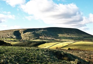
Blacko is a village and civil parish in the Pendle district of Lancashire, England. Before local government reorganisation in 1974 the village lay on the border with the West Riding of Yorkshire. The parish has a population of 672. The village is on the old turnpike road from Nelson to Gisburn (A682). The village enjoys views towards Boulsworth Hill to its southeast, the former cotton town of Nelson, about two miles to its south and Pendle Hill to its west across the valley of Pendle Water.

Barrowford is a large village and civil parish in the Pendle district of Lancashire, England. It is situated to the north of Nelson on the other side of the M65 motorway, and forms part of the Nelson conurbation. It also comprises the area of Lowerford. The parish has a population of 6,171. The community is located near the Forest of Bowland, an Area of Outstanding Natural Beauty while the Borough of Pendle is at the southern edge of the Yorkshire Dales.
Burnley was a Rural district of Lancashire, England from 1894 to 1974. It was named after but did not include the large town of Burnley, which was a county borough.
The Skipton East Lancashire Rail Action Partnership (SELRAP) is a campaign that is looking to reopen the Skipton to Colne railway line, as part of connecting the Lancashire town of Colne to the North Yorkshire town of Skipton. The line between them had been closed in 1970.

Andrew George Stephenson is a British politician serving as a Lord Commissioner of the Treasury since October 2022. He has served as a Whip or Minister continually since June 2017 under four Prime Ministers. A member of the Conservative Party, he has been the Member of Parliament (MP) for Pendle in Lancashire since 2010.

Burnley, in Lancashire, England, has a long history of religious worship, dating from at least before 1122 in the case of the Church of England. The chapel at Towneley Hall was the centre for Roman Catholic worship in Burnley until modern times. Well before the Industrial Revolution, the town saw the emergence of many non-conformist churches and chapels. In 1891 the town was the location of the meeting which saw the creation of the Baptist Union of Great Britain and Ireland. In the late 19th century a Jewish synagogue was established, and in recent times evangelical and free churches have appeared, as well as a large purpose-built mosque.
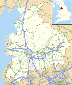
Pendle is a local government district with borough status in Lancashire, England. The council is based in Nelson, the borough's largest town. The borough also includes the towns of Barnoldswick, Brierfield, Colne and Earby along with the surrounding villages and rural areas. Part of the borough lies within the Forest of Bowland Area of Outstanding Natural Beauty.

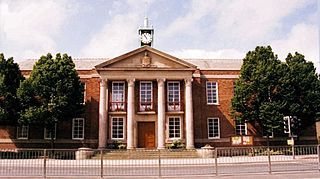
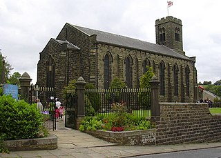
Colne Town Hall is a municipal building in Albert Road, Colne, Lancashire, England. The town hall, which is the meeting place of Colne Town Council, is a grade II listed building.
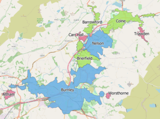
The Burnley built-up area is an urban area or conurbation which extends from the town of Burnley to Padiham, Brierfield, Nelson, Barrowford and Colne in Lancashire, England. The area takes in parts of the boroughs of Burnley and Pendle, and also small parts of Hyndburn and Ribble Valley. It also includes a number of villages such as Blacko, Trawden and Worsthorne. In 2011 the area was recorded at having a population of 149,422. It is the third most populous urban area in Lancashire after Preston and Blackpool, with slightly more people than the urban areas of Cambridge or York.