
Prebold is a settlement in central Slovenia. It is the seat of the Municipality of Prebold. It lies on the edge of the lower Savinja Valley at the northern edge of the Sava Hills west of Celje. The area was part of the traditional region of Styria. The municipality is now included in the Savinja Statistical Region.

Hrastovec is a settlement in the Municipality of Velenje in northern Slovenia. The area was traditionally part of Styria. The municipality is now included in the Savinja Statistical Region.
Kamence is a settlement in the Municipality of Rogaška Slatina in eastern Slovenia, close to the border with Croatia. The area traditionally belonged to the region of Styria. It is now included in the Savinja Statistical Region.
Male Rodne is a settlement in the Municipality of Rogaška Slatina in eastern Slovenia. The entire area traditionally belonged to the Styria region and is now included in the Savinja Statistical Region.
Vidovica is a settlement in the Municipality of Podčetrtek in eastern Slovenia, close to the border with Croatia. The area was traditionally part of the Styria region. It is now included in the Savinja Statistical Region.

Obrežje pri Zidanem Mostu is a settlement in the Municipality of Laško in eastern Slovenia. It lies on the left bank of the Savinja River, close to its confluence with the Sava, opposite Zidani Most. The area was traditionally part of the Styria region. It is now included with the rest of the municipality in the Savinja Statistical Region.
Šentrupert is a settlement in the Municipality of Laško in eastern Slovenia. The area was traditionally part of the Styria region. It is now included with the rest of the municipality in the Savinja Statistical Region.
Širje is a settlement in the Municipality of Laško in eastern Slovenia. It lies on the left bank of the Sava River, immediately northwest of Zidani Most. The area was traditionally part of the Styria region. It is now included with the rest of the municipality in the Savinja Statistical Region.
Lemberg pri Novi Cerkvi is a village in the Municipality of Vojnik in eastern Slovenia. The area was traditionally part of the Styria region. It is now included with the rest of the municipality in the Savinja Statistical Region.
Gorenje pri Zrečah is a settlement in the Municipality of Zreče in northeastern Slovenia. The area was traditionally part of the Styria region. It is now included with the rest of the municipality in the Savinja Statistical Region.
Pongrac is a settlement in the Municipality of Žalec in east-central Slovenia. It lies in the hills south of Žalec. The area is part of the traditional region of Styria. The municipality is now included in the Savinja Statistical Region.

Šempeter v Savinjski Dolini is a village in the Municipality of Žalec in east-central Slovenia. It lies on the left bank of the Savinja River east of Žalec. The Slovenian A1 motorway crosses the territory of the settlement northwest of the village core. The area is part of the traditional region of Styria. The entire municipality of Žalec is now included in the Savinja Statistical Region.
Matke is a settlement in the Municipality of Prebold in east-central Slovenia. It lies in the valley of Kolja Creek, a minor right tributary of the Savinja River, and the surrounding hills southeast of Prebold. The area is part of the traditional region of Styria. The municipality is now included in the Savinja Statistical Region.
Sveti Štefan is a small settlement in the Municipality of Šmarje pri Jelšah in eastern Slovenia. It lies in the hills south of Šmarje in the Kozje region. The area is part of the traditional region of Styria. The municipality is now included in the Savinja Statistical Region.
Vinski Vrh pri Šmarju is a small settlement in the Municipality of Šmarje pri Jelšah in eastern Slovenia. It lies in the hills south of Šmarje. The area is part of the historical Styria region. The municipality is now included in the Savinja Statistical Region.
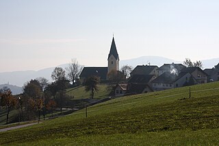
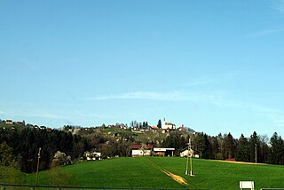
Močle is a village in the Municipality of Šmarje pri Jelšah in eastern Slovenia. It lies in the hills west of Šmarje. The area is part of the historical Styria region. The municipality is now included in the Savinja Statistical Region. It is a clustered village on the south side of a gentle slope. It includes the hamlets of Erpoge and Sveti Lovrenc.
Pečica is a settlement in the Municipality of Šmarje pri Jelšah in eastern Slovenia. It lies in the hills north of Sladka Gora. The area is part of the historical Styria region. The municipality is now included in the Savinja Statistical Region.
Podgaj is a small settlement south of Ponikva in the Municipality of Šentjur in eastern Slovenia. Traditionally the area is part of Styria. The municipality is now included in the Savinja Statistical Region.

Šentvid pri Planini is a village east of Planina pri Sevnici in the Municipality of Šentjur in eastern Slovenia. The area is part of the historical Styria region. The municipality is now included in the Savinja Statistical Region.
Vodule is a settlement in the Municipality of Šentjur in eastern Slovenia. It lies in the hills just east of Dramlje. The area is part of the historical Styria region. The municipality is now included in the Savinja Statistical Region.


