Levec

Last updated
Levec
Slovenia location map.svg
Red pog.svg
Levec
Location in Slovenia
Coordinates: 46°14′26.02″N15°13′0.06″E / 46.2405611°N 15.2166833°E / 46.2405611; 15.2166833 Coordinates: 46°14′26.02″N15°13′0.06″E / 46.2405611°N 15.2166833°E / 46.2405611; 15.2166833
Country Flag of Slovenia.svg Slovenia
Traditional region Styria
Statistical region Savinja
Municipality Žalec
Area
  Total 1.76 km2 (0.68 sq mi)
Elevation 244.3 m (801.5 ft)
Population (2002)
  Total 422
[1]

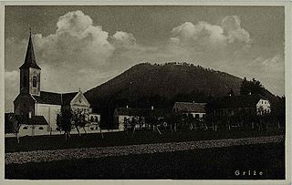
Levec (pronounced  [ˈleːʋəts] ) is a village in the Municipality of Žalec in east-central Slovenia. It lies on the left bank of the Savinja River between Žalec and Celje. The area is part of the traditional region of Styria. The municipality is now included in the Savinja Statistical Region. [2]

Village Small clustered human settlement smaller than a town

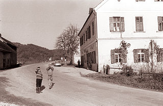
A village is a clustered human settlement or community, larger than a hamlet but smaller than a town, with a population ranging from a few hundred to a few thousand. Though villages are often located in rural areas, the term urban village is also applied to certain urban neighborhoods. Villages are normally permanent, with fixed dwellings; however, transient villages can occur. Further, the dwellings of a village are fairly close to one another, not scattered broadly over the landscape, as a dispersed settlement.

Municipality An administrative division having corporate status and usually some powers of self-government or jurisdiction

A municipality is usually a single administrative division having corporate status and powers of self-government or jurisdiction as granted by national and regional laws to which it is subordinate. It is to be distinguished (usually) from the county, which may encompass rural territory or numerous small communities such as towns, villages and hamlets.

Žalec Place in Styria, Slovenia

Žalec is a town in central Slovenia. It is the seat of the Municipality of Žalec. It lies in the valley of the lower course of the Savinja River west of Celje. The primary economic activity of the region is growing hops, which is reflected by the city's coat-of-arms. The area was part of the traditional region of Styria. The municipality is now included in the Savinja Statistical Region.

Remnants of Roman graves have been regularly uncovered during construction work in the eastern part of the settlement. The site is believed to be the western end of the Roman necropolis of Celeia. [3]

Ancient Rome History of Rome from the 8th-century BC to the 5th-century

In historiography, ancient Rome is Roman civilization from the founding of the Italian city of Rome in the 8th century BC to the collapse of the Western Roman Empire in the 5th century AD, encompassing the Roman Kingdom, Roman Republic and Roman Empire until the fall of the western empire. The civilization began as an Italic settlement in the Italian Peninsula, conventionally founded in 753 BC, that grew into the city of Rome and which subsequently gave its name to the empire over which it ruled and to the widespread civilisation the empire developed. The Roman Empire expanded to become one of the largest empires in the ancient world, though still ruled from the city, with an estimated 50 to 90 million inhabitants and covering 5.0 million square kilometres at its height in AD 117.

Celje Place in Slovenia

Celje is the third-largest town in Slovenia. It is a regional center of the traditional Slovenian region of Styria and the administrative seat of the City Municipality of Celje. The town of Celje is located below Upper Celje Castle at the confluence of the Savinja, Hudinja, Ložnica, and Voglajna rivers in the lower Savinja Valley, and at the crossing of the roads connecting Ljubljana, Maribor, Velenje, and the Central Sava Valley. It lies 238 m (781 ft) above mean sea level (MSL).

Related Research Articles

Dobriša Vas Place in Styria, Slovenia

Dobriša Vas is a settlement in the Municipality of Žalec in east-central Slovenia. It lies on the left bank of the Savinja River southeast of the town of Žalec. The area is part of the traditional region of Styria. The municipality is now included in the Savinja Statistical Region.

Galicija, Žalec Place in Styria, Slovenia

Galicija is a settlement in the Municipality of Žalec in east-central Slovenia. It lies in the Hudinja Hills north of Žalec. The area is part of the traditional region of Styria. The municipality is now included in the Savinja Statistical Region.

Gotovlje Place in Styria, Slovenia

Gotovlje is a settlement in the Municipality of Žalec in east-central Slovenia. The A1 motorway crosses the territory of the settlement north of the village core. The area is part of the traditional region of Styria. The municipality is now included in the Savinja Statistical Region.

Griže, Žalec Place in Styria, Slovenia

Griže is a village on the right bank of the Savinja River in the Municipality of Žalec in east-central Slovenia. The area is part of the traditional region of Styria. The municipality is now included in the Savinja Statistical Region.

Hramše Place in Styria, Slovenia

Hramše is a village in the Municipality of Žalec in east-central Slovenia. It lies in the Hudinja Hills north of Žalec. The area is part of the traditional region of Styria. The municipality is now included in the Savinja Statistical Region.

Kasaze in Styria, Slovenia

Kasaze is a village on the right bank of the Savinja River in the Municipality of Žalec in east-central Slovenia. Traditionally the area was part of the Styria region. The municipality is now included in the Savinja Statistical Region.

Mala Pirešica in Styria, Slovenia

Mala Pirešica is a settlement in the lower Savinja Valley in the Municipality of Žalec in east-central Slovenia. The A1 motorway crosses the territory of the settlement south of the village core. The area is part of the traditional region of Styria. The municipality is now included in the Savinja Statistical Region.

Petrovče Place in Styria, Slovenia

Petrovče is a village on the left bank of the Savinja River in the Municipality of Žalec in east-central Slovenia. The area is part of the traditional region of Styria. The municipality is now included in the Savinja Statistical Region.

Podkraj, Žalec Place in Styria, Slovenia

Podkraj is a settlement in the Municipality of Žalec in east-central Slovenia. It lies in the eastern part of the Ložnica Hills north of Žalec. The area is part of the traditional region of Styria. The municipality is now included in the Savinja Statistical Region.

Podvin, Žalec in Styria, Slovenia

Podvin is a small settlement in the Municipality of Žalec in east-central Slovenia. It lies on Ložnica Creek north of Žalec. The area is part of the traditional region of Styria. The municipality is now included in the Savinja Statistical Region.

Ponikva pri Žalcu Place in Styria, Slovenia

Ponikva pri Žalcu is a village in the Municipality of Žalec in east-central Slovenia. It lies in the Ložnica Hills northwest of Žalec. The area is part of the traditional region of Styria. The municipality is now included in the Savinja Statistical Region.

Spodnje Roje in Styria, Slovenia

Spodnje Roje is a small settlement in the Municipality of Žalec in east-central Slovenia. It lies on the left bank of the Savinja River southwest of Žalec. The area is part of the traditional region of Styria. The municipality is now included in the Savinja Statistical Region.

Šempeter v Savinjski Dolini Place in Styria, Slovenia

Šempeter v Savinjski Dolini is a village in the Municipality of Žalec in east-central Slovenia. It lies on the left bank of the Savinja River east of Žalec. The Slovenian A1 motorway crosses the territory of the settlement northwest of the village core. The area is part of the traditional region of Styria. The entire municipality of Žalec is now included in the Savinja Statistical Region.

Velika Pirešica in Styria, Slovenia

Velika Pirešica is a settlement north of Žalec in east-central Slovenia. The area is part of the traditional region of Styria. The entire Municipality of Žalec is now included in the Savinja Statistical Region.

Vrbje, Žalec in Styria, Slovenia

Vrbje is a settlement in the Municipality of Žalec in east-central Slovenia. It lies south of Žalec on the left bank of the Savinja River. Traditionally the area was part of Styria. The municipality is now included in the Savinja Statistical Region.

Zabukovica Place in Styria, Slovenia

Zabukovica is a settlement in the Municipality of Žalec in east-central Slovenia. It lies in the hills south of Žalec. The area is part of the traditional region of Styria. The Municipality of Žalec is included in the Savinja Statistical Region. Zabukovica includes the hamlets of Kurja Vas, Močle, Odele, Podvine, Porence, Slovenski Dol, Sončni Hrib, and Zabukovška Vas.

Zgornje Grušovlje Place in Styria, Slovenia

Zgornje Grušovlje is a settlement in the Municipality of Žalec in east-central Slovenia. It lies in the lower Savinja Valley northwest of Šempeter v Savinjski Dolini. Traditionally the area was part of Styria. The municipality is now included in the Savinja Statistical Region.

Železno, Žalec Place in Styria, Slovenia

Železno is a small settlement in the Municipality of Žalec in east-central Slovenia. It lies on the southwestern edge of the Hudinja Hills north of Žalec. The area is part of the traditional region of Styria. The municipality is now included in the Savinja Statistical Region.

Grče Place in Styria, Slovenia

Grče is a village in the Municipality of Žalec in east-central Slovenia. It lies on the southwest part of the Ponikva Plateau. The area is part of the traditional region of Styria. The municipality is now included in the Savinja Statistical Region.

References