Liboje

Last updated
Liboje
Slovenia location map.svg
Red pog.svg
Liboje
Location in Slovenia
Coordinates: 46°12′23.08″N15°11′40.26″E / 46.2064111°N 15.1945167°E / 46.2064111; 15.1945167 Coordinates: 46°12′23.08″N15°11′40.26″E / 46.2064111°N 15.1945167°E / 46.2064111; 15.1945167
Country Flag of Slovenia.svg Slovenia
Traditional region Styria
Statistical region Savinja
Municipality Žalec
Area
  Total 9.44 km2 (3.64 sq mi)
Elevation 314.5 m (1,031.8 ft)
Population (2002)
  Total 439
[1]

Liboje (pronounced  [liˈboːjɛ] ) is a settlement in the Municipality of Žalec in east-central Slovenia. It lies in the hills south of Žalec and southwest of Celje. The area is part of the traditional region of Styria. The municipality is now included in the Savinja Statistical Region. [2] It includes the hamlets of Kurja Vas (Slovene : Kurja vas), Straža, and Svetli Dol or Tihi Gaj. [3]

Municipality An administrative division having corporate status and usually some powers of self-government or jurisdiction

A municipality is usually a single administrative division having corporate status and powers of self-government or jurisdiction as granted by national and regional laws to which it is subordinate. It is to be distinguished (usually) from the county, which may encompass rural territory or numerous small communities such as towns, villages and hamlets.

Žalec Place in Styria, Slovenia

Žalec is a town in central Slovenia. It is the seat of the Municipality of Žalec. It lies in the valley of the lower course of the Savinja River west of Celje. The primary economic activity of the region is growing hops, which is reflected by the city's coat-of-arms. The area was part of the traditional region of Styria. The municipality is now included in the Savinja Statistical Region.

Slovenia republic in Central Europe

Slovenia, officially the Republic of Slovenia, is a sovereign state located in southern Central Europe at a crossroads of important European cultural and trade routes. It is bordered by Italy to the west, Austria to the north, Hungary to the northeast, Croatia to the southeast, and the Adriatic Sea to the southwest. It covers 20,273 square kilometers (7,827 sq mi) and has a population of 2.07 million. One of the successor states of the former Yugoslavia, Slovenia is a parliamentary republic and a member of the United Nations, of the European Union, and of NATO. The capital and largest city is Ljubljana.

Contents

Name

Liboje was attested in written records in 1320 as Lybon (and as Liban in 1368, Lybochendorf in 1378, Liboch(e)ndorff in 1409, Loubuen in 1430, and Lybochendorf in 1441). The origin of the name is unclear; it may be derived from a personal name. [4]

History

In addition to agriculture, industry developed early in the settlement. An alum factory as established in 1784, and was converted to glass production in 1807. Glass production was discontinued at the end of the 19th century. Coal mining began in Liboje in 1799. Both the coal mine and the glass works were purchased by the Trbovlje Coal Company in 1889. The owner of the glass works established an elementary school in 1861 for his children. Public education began in Liboje in 1885, and one of the former glass works buildings was converted into a school in 1922. In March 1934 the miners in Liboje staged a hunger strike, and the local cell of the Communist Party was founded the same year. During the Second World War, the coal mine was attacked by a Partisan unit. The Partisans also operated a relay station and other facilities in the area during the war. [3]

Alum chemical compound

An alum is a type of chemical compound, usually a hydrated double sulfate salt of aluminium with the general formula XAl(SO
4
)
2
·12H
2
O
, where X is a monovalent cation such as potassium or ammonium. By itself, "alum" often refers to potassium alum, with the formula KAl(SO
4
)
2
·12H
2
O
. Other alums are named after the monovalent ion, such as sodium alum and ammonium alum.

Yugoslav Partisans Yugoslavian resistance movement

The Yugoslav Partisans, or the National Liberation Army, officially the National Liberation Army and Partisan Detachments of Yugoslavia, was the Communist-led resistance to the Axis powers in occupied Yugoslavia during World War II.

Church

The local church is dedicated to Saint Agnes (Slovene : sveta Neža) and belongs to the Parish of Griže. [5] Its foundations go back to the 14th century and it was first mentioned in written sources in 1540. It was renovated and extended between 1827 and 1828. Subsidence caused the nave to become unstable, and so it was razed. [3] The current structure incorporates the bell tower, sacristy, and chancel of the old church with a new nave built between 1985 and 1999. [5]

Church (building) building constructed for Christian worship

A church building or church house, often simply called a church, is a building used for Christian religious activities, particularly for Christian worship services. The term is often used by Christians to refer to the physical buildings where they worship, but it is sometimes used to refer to buildings of other religions. In traditional Christian architecture, the church is often arranged in the shape of a Christian cross. When viewed from plan view the longest part of a cross is represented by the aisle and the junction of the cross is located at the altar area.

Agnes of Rome Christian martyr

Agnes of Rome is a virgin martyr, venerated as a saint in the Roman Catholic Church, Eastern Orthodox Church, the Anglican Communion, and Lutheranism. She is one of seven women who, along with the Blessed Virgin, are commemorated by name in the Canon of the Mass.

Slovene language language spoken in Slovenia

Slovene or Slovenian belongs to the group of South Slavic languages. It is spoken by approximately 2.5 million speakers worldwide, the majority of whom live in Slovenia. It is the first language of about 2.1 million Slovenian people and is one of the 24 official and working languages of the European Union.

Notable people

Notable people that were born or lived in Liboje include:

Related Research Articles

Hrastnik Place in Styria, Slovenia

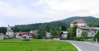
Hrastnik is a town in the Central Sava Valley in central Slovenia. It is the seat of the Municipality of Hrastnik. Traditionally the area was part of the Styria region. The entire municipality is now included in the Central Sava Statistical Region. The town has its own library and school.

Borovnica, Borovnica Place in Inner Carniola, Slovenia

Borovnica is a settlement in the Municipality of Borovnica in the Inner Carniola region of Slovenia. It is about 20 kilometres (12 mi) southwest of the national capital Ljubljana.

Gorenja Vas, Gorenja Vas–Poljane Place in Upper Carniola, Slovenia

Gorenja Vas is a settlement in the Poljane Sora Valley and the administrative centre of the Municipality of Gorenja Vas–Poljane in the Upper Carniola region of Slovenia. In addition to the settlement core of Gorenja Vas itself, the settlement also consists of the hamlets of Sestranska Vas north of the Poljane Sora River, and Trata and Lajše south of the settlement core.

Jazbine, Gorenja Vas–Poljane Place in Upper Carniola, Slovenia

Jazbine is a dispersed settlement in the Municipality of Gorenja Vas–Poljane in the Upper Carniola region of Slovenia.

Dobrova, Dobrova–Polhov Gradec Place in Upper Carniola, Slovenia

Dobrova is a clustered settlement northwest of Ljubljana in the Upper Carniola region of Slovenia. It is the administrative centre of the Municipality of Dobrova–Polhov Gradec. It lies on the road from Ljubljana to Polhov Gradec at the point where roads split off to Horjul to the southwest and to Šentvid, Ljubljana to the northeast. It extends along the flat area to the northeast up to the Gradaščica River and encompasses much of Dobrova Hill to the southwest. Bezenica Creek, Broad Creek, and Ječnik Creek, left tributaries of the Horjulščica River, flow through the hills west of the settlement. Dobrova includes the hamlets of Pod Kotom northwest of the main settlement and Graben southwest of the main settlement.

Šentjošt nad Horjulom Place in Upper Carniola, Slovenia

Šentjošt nad Horjulom is a settlement in the Municipality of Dobrova–Polhov Gradec in the Upper Carniola region of Slovenia. In addition to the main settlement, it also includes the hamlets of Kogel, Krvinet, Kurja Vas, Paradiže, Pišek, Potok, and Stavnik, as well as part of the hamlet of Suhi Dol.

Križevska Vas, Dol pri Ljubljani Place in Upper Carniola, Slovenia

Križevska Vas is a small settlement in the Municipality of Dol pri Ljubljani in the eastern Upper Carniola region of Slovenia.

Povir Place in Slovenian Littoral, Slovenia

Povir is a village in the Municipality of Sežana in the Littoral region of Slovenia. It includes the hamlets of Britof, Dulanja Vas, and Guranja Vas.

Otlica Place in Littoral, Slovenia

Otlica is a dispersed settlement in the hills north of Ajdovščina in the Littoral region of Slovenia. It is made up of smaller clusters of the hamlets of Sibirija, Kitajska, Kurja Vas, and Cerkovna, as well as a number of outlying isolated farms. Together with the ridge-top villages of Predmeja, Kovk, and Gozd, it is part of an area locally known as Gora.

Bojanja Vas Place in White Carniola, Slovenia

Bojanja Vas is a village in the Municipality of Metlika in the White Carniola area of southeastern Slovenia, next to the border with Croatia. The entire area is part of the traditional region of Lower Carniola and is now included in the Southeast Slovenia Statistical Region.

Zajčje Polje in Lower Carniola, Slovenia

Zajčje Polje is a settlement in the Municipality of Kočevje in southern Slovenia. It was inhabited mostly by Gottschee Germans. The area is part of the traditional region of Lower Carniola and is now included in the Southeast Slovenia Statistical Region.

Stari Kot Place in Lower Carniola, Slovenia

Stari Kot is a village in the Municipality of Loški Potok in southern Slovenia, next to the border with Croatia. The area is part of the traditional region of Lower Carniola and is now included in the Southeast Slovenia Statistical Region. It consists of the hamlets of Binkl, Kurja Vas, Pri Ambrožiču, Hrib, and Preska. The main road from Lazec to Prezid runs through the village.

Janče Place in Lower Carniola, Slovenia

Janče is a dispersed settlement in the hills south of the Sava River east of the capital Ljubljana in central Slovenia. It belongs to the City Municipality of Ljubljana. It was part of the traditional region of Lower Carniola and is now included with the rest of the municipality in the Central Slovenia Statistical Region.

Sadinja Vas, Ljubljana Place in Lower Carniola, Slovenia

Sadinja Vas is a settlement in the City Municipality of Ljubljana in central Slovenia. It is part of the traditional region of Lower Carniola and is now included with the rest of the municipality in the Central Slovenia Statistical Region.

Kolovrat, Zagorje ob Savi Place in Upper Carniola, Slovenia

Kolovrat is a settlement in the Municipality of Zagorje ob Savi in central Slovenia. The area is part of the traditional region of Upper Carniola. It is now included with the rest of the municipality in the Central Sava Statistical Region. The settlement includes the hamlets of Kal, Plavišnik, Prevalje, Spodnje Vrtače, Senčna Vas, and Strma Njiva.

Zabukovica Place in Styria, Slovenia

Zabukovica is a settlement in the Municipality of Žalec in east-central Slovenia. It lies in the hills south of Žalec. The area is part of the traditional region of Styria. The Municipality of Žalec is included in the Savinja Statistical Region. Zabukovica includes the hamlets of Kurja Vas, Močle, Odele, Podvine, Porence, Slovenski Dol, Sončni Hrib, and Zabukovška Vas.

Nestoplja Vas Place in Lower Carniola, Slovenia

Nestoplja Vas is a small village in the Municipality of Semič in Slovenia. The area is part of the historical region of Lower Carniola. The municipality is now included in the Southeast Slovenia Statistical Region.

Polica, Grosuplje Place in Lower Carniola, Slovenia

Polica is a settlement in the Municipality of Grosuplje in central Slovenia. The area is part of the historical region of Lower Carniola. The municipality is now included in the Central Slovenia Statistical Region. Polica includes the hamlets of Bliska Vas, Žabja Vas, Hrib, and Goričane.

Gabrje pri Stični Place in Lower Carniola, Slovenia

Gabrje pri Stični is a settlement just north of Stična in the Municipality of Ivančna Gorica in central Slovenia. The area is part of the historical region of Lower Carniola. The municipality is now included in the Central Slovenia Statistical Region. The settlement includes the hamlets of Kurja Vas, Potok, Pungrt, and Nograd.

Grče Place in Styria, Slovenia

Grče is a village in the Municipality of Žalec in east-central Slovenia. It lies on the southwest part of the Ponikva Plateau. The area is part of the traditional region of Styria. The municipality is now included in the Savinja Statistical Region.

References

  1. Statistical Office of the Republic of Slovenia Archived November 18, 2008, at the Wayback Machine.
  2. Žalec municipal site
  3. 1 2 3 4 Savnik, Roman, ed. 1976. Krajevni leksikon Slovenije, vol. 3. Ljubljana: Državna založba Slovenije. pp. 501–502.
  4. Snoj, Marko. 2009. Etimološki slovar slovenskih zemljepisnih imen. Ljubljana: Modrijan and Založba ZRC, p. 233.
  5. 1 2 Slovenian Ministry of Culture register of national heritage Archived July 12, 2010, at the Wayback Machine . reference number ešd 3007