Migojnice

Last updated
Migojnice
Village

Postcard of Migojnice.jpg

Postcard of Migojnice
Slovenia location map.svg
Red pog.svg
Migojnice
Location in Slovenia
Coordinates: 46°13′45.56″N15°9′31.27″E / 46.2293222°N 15.1586861°E / 46.2293222; 15.1586861 Coordinates: 46°13′45.56″N15°9′31.27″E / 46.2293222°N 15.1586861°E / 46.2293222; 15.1586861
Country Flag of Slovenia.svg Slovenia
Traditional region Styria
Statistical region Savinja
Municipality Žalec
Area
  Total 2.57 km2 (0.99 sq mi)
Elevation 288.7 m (947.2 ft)
Population (2002)
  Total 629
[1]

Migojnice (pronounced  [miˈɡoːi̯nitsɛ] ) is a village on the right bank of the Savinja River in the Municipality of Žalec in east-central Slovenia. The area is part of the traditional region of Styria. The municipality is now included in the Savinja Statistical Region. [2]

Village Small clustered human settlement smaller than a town

A village is a clustered human settlement or community, larger than a hamlet but smaller than a town, with a population ranging from a few hundred to a few thousand. Though villages are often located in rural areas, the term urban village is also applied to certain urban neighborhoods. Villages are normally permanent, with fixed dwellings; however, transient villages can occur. Further, the dwellings of a village are fairly close to one another, not scattered broadly over the landscape, as a dispersed settlement.

Savinja river in Slovenia

The Savinja is a river in northeast Slovenia which flows mostly in the Upper and Lower Savinja Valley and through the cities of Celje and Laško. The Savinja is the main river of the Savinja Alps. It flows into the Sava River at the town of Zidani Most. It has often flooded, such as in the 1960s, 1990, and 1995. The Savinja has a length of 101.75 kilometres (63.22 mi) and a catchment area of 1,847.7 km2 (713.4 sq mi).

Municipality An administrative division having corporate status and usually some powers of self-government or jurisdiction

A municipality is usually a single administrative division having corporate status and powers of self-government or jurisdiction as granted by national and regional laws to which it is subordinate. It is to be distinguished (usually) from the county, which may encompass rural territory or numerous small communities such as towns, villages and hamlets.

Contents

Name

The village was attested in written sources in 1265–67 as Makoyn, and in 1763–87 as Megoiniz. The origin of the name is unclear, but it may be derived from *Maligojnice (based on the personal name *Maligojь) with syncope of the second syllable (cf. Magozd < *Mal(i) gozd). If so, the name would originally mean 'place where Maligojь's people live'. [3]

Magozd Place in Slovenian Littoral, Slovenia

Magozd is a settlement in the Municipality of Kobarid in the Littoral region of Slovenia.

Church

The local church is dedicated to Our Lady of Lourdes (Slovene : Lurška Mati božja) and belongs to the Parish of Griže. It was built between 1888 and 1891. [4]

Church (building) building constructed for Christian worship

A church building or church house, often simply called a church, is a building used for Christian religious activities, particularly for Christian worship services. The term is often used by Christians to refer to the physical buildings where they worship, but it is sometimes used to refer to buildings of other religions. In traditional Christian architecture, the church is often arranged in the shape of a Christian cross. When viewed from plan view the longest part of a cross is represented by the aisle and the junction of the cross is located at the altar area.

Our Lady of Lourdes Title of Mary, mother of Jesus, related to her alleged apparitions in Lourdes

Our Lady of Lourdes is a Roman Catholic title of the Blessed Virgin Mary venerated in honour of the Marian apparitions that reportedly occurred in 1858 in the vicinity of Lourdes in France. The first of these is the apparition of 11 February 1858, when 14-year old Bernadette Soubirous told her mother that a "lady" spoke to her in the cave of Massabielle while she was gathering firewood with her sister and a friend. Similar apparitions of the "Lady" were reported on seventeen occasions that year, until the climax revelation of Our Lady of the Immaculate Conception took place.

Slovene language language spoken in Slovenia

Slovene or Slovenian belongs to the group of South Slavic languages. It is spoken by approximately 2.5 million speakers worldwide, the majority of whom live in Slovenia. It is the first language of about 2.1 million Slovenian people and is one of the 24 official and working languages of the European Union.

Related Research Articles

Žalec Place in Styria, Slovenia

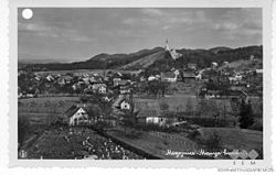
Žalec is a town in central Slovenia. It is the seat of the Municipality of Žalec. It lies in the valley of the lower course of the Savinja River west of Celje. The primary economic activity of the region is growing hops, which is reflected by the city's coat-of-arms. The area was part of the traditional region of Styria. The municipality is now included in the Savinja Statistical Region.

Arja Vas Place in Styria, Slovenia

Arja Vas is a roadside settlement in the Municipality of Žalec in east-central Slovenia. The A1 motorway crosses the territory of the settlement north of the village. The area is part of the traditional region of Styria. The municipality is now included in the Savinja Statistical Region.

Dobriša Vas Place in Styria, Slovenia

Dobriša Vas is a settlement in the Municipality of Žalec in east-central Slovenia. It lies on the left bank of the Savinja River southeast of the town of Žalec. The area is part of the traditional region of Styria. The municipality is now included in the Savinja Statistical Region.

Griže, Žalec Place in Styria, Slovenia

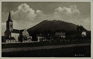
Griže is a village on the right bank of the Savinja River in the Municipality of Žalec in east-central Slovenia. The area is part of the traditional region of Styria. The municipality is now included in the Savinja Statistical Region.

Hramše Place in Styria, Slovenia

Hramše is a village in the Municipality of Žalec in east-central Slovenia. It lies in the Hudinja Hills north of Žalec. The area is part of the traditional region of Styria. The municipality is now included in the Savinja Statistical Region.

Kale, Žalec Place in Styria, Slovenia

Kale is a village in the Municipality of Žalec in east-central Slovenia. It lies in the Ložnica Hills north of Šempeter v Savinjski Dolini. The area is part of the traditional region of Styria. The municipality is now included in the Savinja Statistical Region.

Kasaze in Styria, Slovenia

Kasaze is a village on the right bank of the Savinja River in the Municipality of Žalec in east-central Slovenia. Traditionally the area was part of the Styria region. The municipality is now included in the Savinja Statistical Region.

Levec in Styria, Slovenia

Levec is a village in the Municipality of Žalec in east-central Slovenia. It lies on the left bank of the Savinja River between Žalec and Celje. The area is part of the traditional region of Styria. The municipality is now included in the Savinja Statistical Region.

Ložnica pri Žalcu Place in Styria, Slovenia

Ložnica pri Žalcu is a settlement north of Žalec in east-central Slovenia. The A1 motorway crosses the territory of the settlement north of the village. The area is part of the traditional region of Styria. The entire Municipality of Žalec is now included in the Savinja Statistical Region.

Mala Pirešica in Styria, Slovenia

Mala Pirešica is a settlement in the lower Savinja Valley in the Municipality of Žalec in east-central Slovenia. The A1 motorway crosses the territory of the settlement south of the village core. The area is part of the traditional region of Styria. The municipality is now included in the Savinja Statistical Region.

Petrovče Place in Styria, Slovenia

Petrovče is a village on the left bank of the Savinja River in the Municipality of Žalec in east-central Slovenia. The area is part of the traditional region of Styria. The municipality is now included in the Savinja Statistical Region.

Podkraj, Žalec Place in Styria, Slovenia

Podkraj is a settlement in the Municipality of Žalec in east-central Slovenia. It lies in the eastern part of the Ložnica Hills north of Žalec. The area is part of the traditional region of Styria. The municipality is now included in the Savinja Statistical Region.

Podlog v Savinjski Dolini Place in Styria, Slovenia

Podlog v Savinjski Dolini is a settlement in the Savinja Valley in the Municipality of Žalec in east-central Slovenia. It lies northeast of Šempeter. The area is part of the traditional region of Styria. The municipality is now included in the Savinja Statistical Region.

Ponikva pri Žalcu Place in Styria, Slovenia

Ponikva pri Žalcu is a village in the Municipality of Žalec in east-central Slovenia. It lies in the Ložnica Hills northwest of Žalec. The area is part of the traditional region of Styria. The municipality is now included in the Savinja Statistical Region.

Ruše, Žalec in Styria, Slovenia

Ruše is a small settlement in the Municipality of Žalec in east-central Slovenia. The A1 motorway runs just north of the village. Traditionally the area was part of Styria. The municipality is now included in the Savinja Statistical Region.

Spodnje Roje in Styria, Slovenia

Spodnje Roje is a small settlement in the Municipality of Žalec in east-central Slovenia. It lies on the left bank of the Savinja River southwest of Žalec. The area is part of the traditional region of Styria. The municipality is now included in the Savinja Statistical Region.

Šempeter v Savinjski Dolini Place in Styria, Slovenia

Šempeter v Savinjski Dolini is a village in the Municipality of Žalec in east-central Slovenia. It lies on the left bank of the Savinja River east of Žalec. The Slovenian A1 motorway crosses the territory of the settlement northwest of the village core. The area is part of the traditional region of Styria. The entire municipality of Žalec is now included in the Savinja Statistical Region.

Vrbje, Žalec in Styria, Slovenia

Vrbje is a settlement in the Municipality of Žalec in east-central Slovenia. It lies south of Žalec on the left bank of the Savinja River. Traditionally the area was part of Styria. The municipality is now included in the Savinja Statistical Region.

Železno, Žalec Place in Styria, Slovenia

Železno is a small settlement in the Municipality of Žalec in east-central Slovenia. It lies on the southwestern edge of the Hudinja Hills north of Žalec. The area is part of the traditional region of Styria. The municipality is now included in the Savinja Statistical Region.

Grče Place in Styria, Slovenia

Grče is a village in the Municipality of Žalec in east-central Slovenia. It lies on the southwest part of the Ponikva Plateau. The area is part of the traditional region of Styria. The municipality is now included in the Savinja Statistical Region.

References

  1. Statistical Office of the Republic of Slovenia
  2. Žalec municipal site
  3. Snoj, Marko. 2009. Etimološki slovar slovenskih zemljepisnih imen. Ljubljana: Modrijan and Založba ZRC, p. 262.
  4. Slovenian Ministry of Culture register of national heritage reference number ešd 3547