Zgornje Grušovlje

Last updated
Zgornje Grušovlje
Slovenia location map.svg
Red pog.svg
Zgornje Grušovlje
Location in Slovenia
Coordinates: 46°16′23.51″N15°6′30.97″E / 46.2731972°N 15.1086028°E / 46.2731972; 15.1086028 Coordinates: 46°16′23.51″N15°6′30.97″E / 46.2731972°N 15.1086028°E / 46.2731972; 15.1086028
Country Flag of Slovenia.svg Slovenia
Traditional region Styria
Statistical region Savinja
Municipality Žalec
Area
  Total 1.39 km2 (0.54 sq mi)
Elevation 279.6 m (917.3 ft)
Population (2002)
  Total 181
[1]

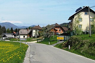
Zgornje Grušovlje (pronounced  [ˈzɡoːɾnjɛ ɡɾuˈʃoːu̯ljɛ] ) is a settlement in the Municipality of Žalec in east-central Slovenia. It lies in the lower Savinja Valley northwest of Šempeter v Savinjski Dolini. Traditionally the area was part of Styria. The municipality is now included in the Savinja Statistical Region. [2]

Municipality An administrative division having corporate status and usually some powers of self-government or jurisdiction

A municipality is usually a single urban administrative division having corporate status and powers of self-government or jurisdiction as granted by national and regional laws to which it is subordinate. It is to be distinguished (usually) from the county, which may encompass rural territory or numerous small communities such as towns, villages and hamlets.

Žalec Place in Styria, Slovenia

Žalec is a town in central Slovenia. It is the seat of the Municipality of Žalec. It lies in the valley of the lower course of the Savinja River west of Celje. The primary economic activity of the region is growing hops, which is reflected by the city's coat-of-arms. The area was part of the traditional region of Styria. The municipality is now included in the Savinja Statistical Region.

Slovenia republic in Central Europe

Slovenia, officially the Republic of Slovenia, is a sovereign state located in southern Central Europe at a crossroads of important European cultural and trade routes. It is bordered by Italy to the west, Austria to the north, Hungary to the northeast, Croatia to the southeast, and the Adriatic Sea to the southwest. It covers 20,273 square kilometers (7,827 sq mi) and has a population of 2.07 million. One of the successor states of the former Yugoslavia, Slovenia is a parliamentary republic and a member of the United Nations, of the European Union, and of NATO. The capital and largest city is Ljubljana.

The hamlet of Dolge Njive (Slovene : Dolge njive) in the settlement is the site of a Roman Villa rustica. [3]

Slovene language language spoken in Slovenia

Slovene or Slovenian belongs to the group of South Slavic languages. It is spoken by approximately 2.5 million speakers worldwide, the majority of whom live in Slovenia. It is the first language of about 2.1 million Slovenian people and is one of the 24 official and working languages of the European Union.

Ancient Rome History of Rome from the 8th-century BC to the 5th-century

In historiography, ancient Rome is Roman civilization from the founding of the city of Rome in the 8th century BC to the collapse of the Western Roman Empire in the 5th century AD, encompassing the Roman Kingdom, Roman Republic and Roman Empire until the fall of the western empire. The civilization began as an Italic settlement in the Italian peninsula, dating from the 8th century BC, that grew into the city of Rome and which subsequently gave its name to the empire over which it ruled and to the widespread civilisation the empire developed. The Roman empire expanded to become one of the largest empires in the ancient world, though still ruled from the city, with an estimated 50 to 90 million inhabitants and covering 5.0 million square kilometres at its height in AD 117.

Villa rustica Roman villa set in the open countryside, often as the hub of a large agricultural estate

Villa rustica was the term used by the ancient Romans to denote a villa set in the open countryside, often as the hub of a large agricultural estate (latifundium). The adjective rusticum was used to distinguish it from an urban or resort villa. The villa rustica would thus serve both as a residence of the landowner and his family and also as a farm management centre. It would often comprise separate buildings to accommodate farm labourers and sheds and barns for animals and crops. In modern British archaeology, a villa rustica is commonly referred to simply as a "Roman villa".

Related Research Articles

Dolge Njive, Gorenja Vas–Poljane Place in Upper Carniola, Slovenia

Dolge Njive is a small settlement next to Lučine in the Municipality of Gorenja Vas–Poljane in the Upper Carniola region of Slovenia.

Zgornje Pobrežje in Styria, Slovenia

Zgornje Pobrežje is a settlement on the right bank of the Savinja River in the Municipality of Rečica ob Savinji in Slovenia. The area traditionally belonged to the Styria region and is now included in the Savinja Statistical Region.

Zgornje Negonje in Styria, Slovenia

Zgornje Negonje is a settlement in the Municipality of Rogaška Slatina in eastern Slovenia. It lies on the southeastern slopes of Mount Boč. The wider area around Rogaška Slatina was traditionally part of the region of Styria. It is now included in the Savinja Statistical Region.

Zgornje Sečovo in Styria, Slovenia

Zgornje Sečovo is a settlement in the Municipality of Rogaška Slatina in eastern Slovenia. The wider area around Rogaška Slatina was traditionally part of the region of Styria. It is now included in the Savinja Statistical Region.

Dolge Njive, Lenart in Styria, Slovenia

Dolge Njive is a settlement in the Slovene Hills in the Municipality of Lenart in northeastern Slovenia. The area was part of the traditional region of Styria. It is now included in the Drava Statistical Region.

Zgornje Laže in Styria, Slovenia

Zgornje Laže is a small settlement in the Municipality of Slovenske Konjice in eastern Slovenia. It lies in the hills north of Spodnje Laže. Traditionally the area was part of Styria. The entire municipality is now included in the Savinja Statistical Region.

Zgornje Gorče in Styria, Slovenia

Zgornje Gorče is a settlement in the Lower Savinja Valley in the Municipality of Braslovče in Slovenia. Traditionally the area was part of the Styria region. The municipality is now included in the Savinja Statistical Region.

Dobriša Vas in Styria, Slovenia

Dobriša Vas is a settlement in the Municipality of Žalec in east-central Slovenia. It lies on the left bank of the Savinja River southeast of the town of Žalec. The area is part of the traditional region of Styria. The municipality is now included in the Savinja Statistical Region.

Levec in Styria, Slovenia

Levec is a village in the Municipality of Žalec in east-central Slovenia. It lies on the left bank of the Savinja River between Žalec and Celje. The area is part of the traditional region of Styria. The municipality is now included in the Savinja Statistical Region.

Mala Pirešica in Styria, Slovenia

Mala Pirešica is a settlement in the lower Savinja Valley in the Municipality of Žalec in east-central Slovenia. The A1 motorway crosses the territory of the settlement south of the village core. The area is part of the traditional region of Styria. The municipality is now included in the Savinja Statistical Region.

Podvin, Žalec in Styria, Slovenia

Podvin is a small settlement in the Municipality of Žalec in east-central Slovenia. It lies on Ložnica Creek north of Žalec. The area is part of the traditional region of Styria. The municipality is now included in the Savinja Statistical Region.

Spodnje Roje in Styria, Slovenia

Spodnje Roje is a small settlement in the Municipality of Žalec in east-central Slovenia. It lies on the left bank of the Savinja River southwest of Žalec. The area is part of the traditional region of Styria. The municipality is now included in the Savinja Statistical Region.

Zgornje Roje in Styria, Slovenia

Zgornje Roje is a settlement in the Municipality of Žalec in east-central Slovenia. It lies on the left bank of the Savinja River southeast of Šempeter v Savinjski Dolini. Traditionally the area was part of Styria. The municipality is now included in the Savinja Statistical Region.

Vrbje, Žalec in Styria, Slovenia

Vrbje is a settlement in the Municipality of Žalec in east-central Slovenia. It lies south of Žalec on the left bank of the Savinja River. Traditionally the area was part of Styria. The municipality is now included in the Savinja Statistical Region.

Zalog pri Šempetru Place in Styria, Slovenia

Zalog pri Šempetru is a settlement in the Municipality of Žalec in east-central Slovenia. It lies in the hills above the left bank of the Ložnica River, a left tributary of the Savinja north of Šempeter v Savinjski Dolini. The area is part of the traditional region of Styria. The municipality is now included in the Savinja Statistical Region.

Zaloška Gorica in Styria, Slovenia

Zaloška Gorica is a settlement in the Municipality of Žalec in east-central Slovenia. The area is part of the traditional region of Styria. The municipality is now included in the Savinja Statistical Region.

Zavrh pri Galiciji in Styria, Slovenia

Zavrh pri Galiciji is a settlement in the Municipality of Žalec in east-central Slovenia. It lies in the Hudinja Hills northeast of Žalec. The area is included in the Savinja Statistical Region and is part of the traditional region of Styria.

Zgornje Tinsko in Styria, Slovenia

Zgornje Tinsko is a settlement in the Municipality of Šmarje pri Jelšah in eastern Slovenia. It lies in the Kozje region in the hills south of Šmarje. The area is part of the traditional region of Styria. The municipality is now included in the Savinja Statistical Region.

Zgornje Slemene in Styria, Slovenia

Zgornje Slemene is a small dispersed settlement in the Municipality of Šentjur in eastern Slovenia. It lies in the hills north of Dramlje. The area is part of the historical region of Styria. The municipality is now included in the Savinja Statistical Region.

Zgornje Selce in Styria, Slovenia

Zgornje Selce is a settlement in the Municipality of Šentjur in eastern Slovenia. It lies between Ponikva and Grobelno. The railway line from Celje to Maribor runs along the western edge of the settlement's territory. The area is part of the historical region of Styria. The municipality is now included in the Savinja Statistical Region.

References