
Žalec is a town in central Slovenia. It is the seat of the Municipality of Žalec. It lies in the valley of the lower course of the Savinja River west of Celje. The primary economic activity of the region is growing hops, which is reflected by the city's coat-of-arms. The area was part of the traditional region of Styria. The municipality is now included in the Savinja Statistical Region.

Šmartno v Rožni Dolini is a settlement in the City Municipality of Celje in eastern Slovenia. It lies on the northern outskirts of Celje. The area was traditionally part of the Styria region. It is now included with the rest of the municipality in the Savinja Statistical Region.
Slatina v Rožni Dolini is a settlement in the City Municipality of Celje in eastern Slovenia. It lies on the northern outskirts of Celje. The area was traditionally part of the Styria region. It is now included with the rest of the municipality in the Savinja Statistical Region.
Dobriša Vas is a settlement in the Municipality of Žalec in east-central Slovenia. It lies on the left bank of the Savinja River southeast of the town of Žalec. The area is part of the traditional region of Styria. The municipality is now included in the Savinja Statistical Region.
Kale is a village in the Municipality of Žalec in east-central Slovenia. It lies in the Ložnica Hills north of Šempeter v Savinjski Dolini. The area is part of the traditional region of Styria. The municipality is now included in the Savinja Statistical Region.
Mala Pirešica is a settlement in the lower Savinja Valley in the Municipality of Žalec in east-central Slovenia. The A1 motorway crosses the territory of the settlement south of the village core. The area is part of the traditional region of Styria. The municipality is now included in the Savinja Statistical Region.
Podvin is a small settlement in the Municipality of Žalec in east-central Slovenia. It lies on Ložnica Creek north of Žalec. The area is part of the traditional region of Styria. The municipality is now included in the Savinja Statistical Region.
Spodnje Grušovlje is a small settlement in the Municipality of Žalec in east-central Slovenia. It lies in the lower Savinja Valley north of Šempeter v Savinjski Dolini. The area is part of the traditional region of Styria. The municipality is now included in the Savinja Statistical Region.
Spodnje Roje is a small settlement in the Municipality of Žalec in east-central Slovenia. It lies on the left bank of the Savinja River southwest of Žalec. The area is part of the traditional region of Styria. The municipality is now included in the Savinja Statistical Region.
Zgornje Roje is a settlement in the Municipality of Žalec in east-central Slovenia. It lies on the left bank of the Savinja River southeast of Šempeter v Savinjski Dolini. Traditionally the area was part of Styria. The municipality is now included in the Savinja Statistical Region.

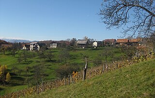
Šempeter v Savinjski Dolini is a village in the Municipality of Žalec in east-central Slovenia. It lies on the left bank of the Savinja River east of Žalec. The Slovenian A1 motorway crosses the territory of the settlement northwest of the village core. The area is part of the traditional region of Styria. The entire municipality of Žalec is now included in the Savinja Statistical Region.
Velika Pirešica is a settlement north of Žalec in east-central Slovenia. The area is part of the traditional region of Styria. The entire Municipality of Žalec is now included in the Savinja Statistical Region.
Vrbje is a settlement in the Municipality of Žalec in east-central Slovenia. It lies south of Žalec on the left bank of the Savinja River. Traditionally the area was part of Styria. The municipality is now included in the Savinja Statistical Region.

Zabukovica is a settlement in the Municipality of Žalec in east-central Slovenia. It lies in the hills south of Žalec. The area is part of the traditional region of Styria. The Municipality of Žalec is included in the Savinja Statistical Region. Zabukovica includes the hamlets of Kurja Vas, Močle, Odele, Podvine, Porence, Slovenski Dol, Sončni Hrib, and Zabukovška Vas.
Zalog pri Šempetru is a settlement in the Municipality of Žalec in east-central Slovenia. It lies in the hills above the left bank of the Ložnica River, a left tributary of the Savinja north of Šempeter v Savinjski Dolini. The area is part of the traditional region of Styria. The municipality is now included in the Savinja Statistical Region.
Zgornje Grušovlje is a settlement in the Municipality of Žalec in east-central Slovenia. It lies in the lower Savinja Valley northwest of Šempeter v Savinjski Dolini. Traditionally the area was part of Styria. The municipality is now included in the Savinja Statistical Region.
Pondor is a small village in the Municipality of Tabor in central Slovenia. It lies on the edge of the Savinja Valley, just off the regional road from Vransko to Šempeter v Savinjski Dolini. The area is part of the traditional region of Styria. The municipality is now included in the Savinja Statistical Region.
Podlog pod Bohorjem is a settlement east of Planina pri Sevnici in the Municipality of Šentjur in eastern Slovenia. The area is part of the historical Styria region. The municipality is now included in the Savinja Statistical Region.
Šempeter may refer to several places in Slovenia:
Sveti Peter may refer to several places in Slovenia:


