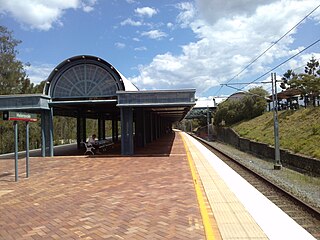
Helensvale railway station is a major public transport interchange in Gold Coast suburb of Helensvale. Helensvale railway station is served by the Queensland Rail Citytrain network Gold Coast line, G:link light rail and Surfside Buslines bus services.
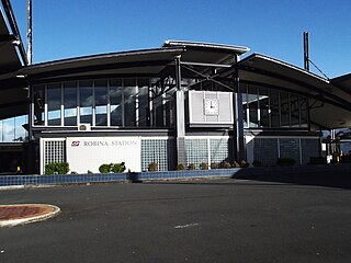
Robina railway station is located on the Gold Coast line in Queensland, Australia. It serves the Gold Coast suburb of Robina.
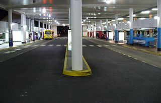
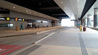
The Pacific Fair Bus Station at Broadbeach is serviced by Surfside Buslines. It is part of the Pacific Fair Shopping Centre and is close to Broadbeach Library, The Star Gold Coast and the Gold Coast Convention & Exhibition Centre.

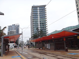
G:link, also known as the Gold Coast Light Rail, is a light rail system serving the Gold Coast in Queensland, Australia. The system forms part of the TransLink's South East Queensland public transport network and consists of a single 20-kilometre (12 mi) line of nineteen stations. Helensvale railway station is the northern terminus of the system, while Broadbeach South is the southern terminus. The line opened on 20 July 2014 and was extended northwest from Gold Coast University Hospital to Helensvale on 17 December 2017.

The Gold Coast is the largest regional city and fastest growing city in Australia. As a result, the Gold Coast has a wide range of public and private transport options from cars and bikes to buses, heavy rail and light rail. The car is the dominant mode of transport in the city with an extensive arterial road network that connects the standard residential streets with major suburbs and motorways.

Mermaid Waters is a suburb on the Gold Coast in Queensland, Australia. At the 2016 census, Mermaid Waters had a population of 12,045.

The Gold Coast Highway in Queensland, Australia links the coastal suburbs of the Gold Coast. 39.8 kilometres (24.7 mi) in length, the highway runs from near the Pacific Motorway at Pacific Pines to the Pacific Motorway at Tweed Heads. It passes through the numerous popular tourist areas including Surfers Paradise and Broadbeach, a commercial centre at Southport, residential areas, shopping centres and the Gold Coast (Coolangatta) Airport.

Broadbeach North light rail station located in the suburb of Broadbeach is serviced by the Gold Coast light rail system known as the G:link. The station serves the northern end of the Broadbeach precinct, offering direct access to the Gold Coast Convention and Exhibition Centre, Oasis Shopping Centre and the Star Casino.
Florida Gardens light rail station is serviced by the Gold Coast light rail system known as the G:link. The station services the very southern end of Surfers Paradise, the Gold Coast's key tourist precinct. The station is located in median strip of the Gold Coast Highway and provides access to local beaches, only a short walk away.

Northcliffe light rail station is located on the southern end of Surfers Paradise Blvd on the corner of Thorton St in the suburb of Surfers Paradise, Queensland, Australia, Gold Coast's key tourist destination. The station is serviced by the Gold Coast G:link light rail system that connects Broadbeach South with Helensvale via Surfers Paradise and Southport.
Surfers Paradise light rail station is located on the corner of Clifford St and Surfers Paradise Blvd. The station is situated centrally of suburb of Surfers Paradise, the key tourist destination in the city of the Gold Coast. Surfers Paradise light rail station is serviced by the city's G:link light rail system that connects Broadbeach South to Helensvale. The station provides direct access to the Q1 residential tower,the tallest residential high rise in the southern hemisphere. The station also provides excellent exposure to numerous hotels and holiday apartments.

Cypress Avenue light rail station is an important public transport interchange in the Gold Coast suburb of Surfers Paradise. The station is part of the Gold Coast's G:link light rail system situated on the corner of Cypress Avenue and Surfers Paradise Boulevard. The G:link connects Broadbeach South with Helensvale railway station via the key activity centres of Surfers Paradise and Southport. Cypress Avenue also provides a bus connection to Nerang via the Nerang railway station.

Southport South light rail station is a major light rail stop in the Gold Coast suburb of Southport, the city's Central Business District. The station is situated on the corner of Scarborough Street and Queen Street and services the southern portion of the Gold Coast CBD precinct. Southport South light rail station is serviced by the Gold Coast G:link light rail system with services as frequent as 7 minutes.

Southport light rail station is a major public transport interchange in the Gold Coast suburb of Southport, the Gold Coast's CBD. The Southport light rail station and the Southport bus station provide an important bus - light rail interchange for the Gold Coast Central Business District. The station opened in July 2014 with the introduction of the light rail system known as the G:link.

Griffith University light rail station is located on the corner of Engineering Drive and Parklands Drive in the Gold Coast suburb of Southport. The station is part of the Gold Coast's G:link light rail system, servicing the southern portion of the Gold Coast Health and Knowledge precinct. Griffith University light rail station is located alongside the southern end of Gold Coast campus of Griffith University and provides direct access to the Gold Coast Private Hospital. Serval bus routes servicing the station provide connections to surrounding suburbs.
Gold Coast University Hospital light rail station is a major public transport interchange, providing an important bus - light rail interchange for the Gold Coast suburb of Southport. GCUH is part of the Gold Coast's G:link light rail network and was the original northern terminus of the G:link until an extension was completed to Helensvale in 2017. The Gold Coast University Hospital station is the only underground light rail station for network and provides a bus interchange located on the street level.
Parkwood East light rail station is located off Faldo Court and adjacent to Smith Street Motorway on the eastern portion of Parkwood, a suburb on the Gold Coast. The station is serviced by the Gold Coast G:link light rail system and provides a bus connection. Parkwood East light rail station services the local residential community.


