King George Square busway station

Last updated

King George Square
K george square station.jpg
General information
Location King George Square, Brisbane
Coordinates 27°28′07″S153°01′27″E / 27.468603°S 153.024136°E / -27.468603; 153.024136
Owned by Department of Transport & Main Roads
Operated by Transport for Brisbane
Line(s) Northern Busway
Platforms2
Bus stands12
Construction
Structure typeUnderground
Bicycle facilitiesKing George Square Cycle Centre
AccessibleYes
Other information
Station code 010781 (platform 1A)
010783 (platform 1B)
010785 (platform 1C)
010787 (platform 1D)
010789 (platform 1E)
010791 (platform 1F)
010780 (platform 2A)
010782 (platform 2B)
010784 (platform 2C)
010786 (platform 2D)
010788 (platform 2E)
010790 (platform 2F)
Fare zone go card 1
Website TransLink
History
Opened19 May 2008
Services
Preceding station Translink Following station
Cultural Centre
Terminus
Northern Busway Roma Street
towards Kedron Brook
Proposed extension to Bracken Ridge beyond Kedron Brook.

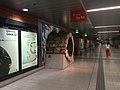
King George Square busway station is located in Brisbane, Queensland, Australia serving the Brisbane central business district. It is located beneath King George Square and marks the start of the Northern Busway. The station has twelve stops on two platforms; access to these platforms is via an underground concourse which can be accessed from Ann Street or Adelaide Street. Passengers wait behind automatic doors on the stop that is assigned to their bus. It opened on 19 May 2008.

Contents

Construction

Segment of the Wheat Creek Culvert on display at the King George Square busway station, 2015 Segment of the Wheat Creek Culvert on display in the King George Square busway station, 2015.JPG
Segment of the Wheat Creek Culvert on display at the King George Square busway station, 2015

Construction of the King George Square busway station was announced in March 2005. [1] Construction commenced in early 2006 and the station opened on 19 May 2008 when the Northern Busway was extended from Normanby. [2] [3] The lower two levels of the King George Square Car Park were demolished to make way for the station. The heritage-listed Wheat Creek Culvert (built in 1861) which ran from under King George Square out into Adelaide Street was also demolished. A short segment of the culvert has been preserved as a display in the bus station. [4]

A bus tunnel has been constructed under Albert Street to link the station with Queen Street bus station. The bus tunnel replaced one of the tunnel exit ramps to the Queen Street station on Albert Street (see photo below). As part of construction, the space in Albert Street above the new tunnel has been converted into a pedestrian mall extending the Queen Street Mall.

Adelaide Street entrance to the busway Entrance to King George Square busway station.jpg
Adelaide Street entrance to the busway

In conjunction with the building of the station, there was a national design competition for the redevelopment of King George Square. The winning entry was entitled A Space in Transition by UrbisJHD. [5] Construction of the Square was completed in October 2009. [6] The re-design of the square and its busway entrances attracted criticism from professional urban designers and the public. [7]

In 2021 a tunnel was dug from the busway station to Adelaide Street for the Brisbane Metro project. [8]

Facilities

King George Square busway station has 12 stops on two platforms (6 stops each labelled 1A-1F and 2A-2F). Passengers wait behind automatic doors at allocated stops rather than hailing buses. Passengers enter the station from either Ann or Adelaide Streets and then select the desired platform via an underground concourse at each end.

The station also features a bike station, cycle2city, located on the Ann Street Concourse. However, bicycles are not allowed on the station's platforms.

When the station originally opened, it included a Transport Information Centre at the Ann Street entrance, this however was closed on 29 September 2012. [9]

King George Square Busway Station.jpg
Station concourse

Services

King George Square busway station primarily services routes travelling to the Northern and Western Suburbs (departing from Platform 1). A small number of routes travelling to Southern and Eastern Suburbs via the South East Busway depart from Platform 2. [10]

Connection to Queen Street

No Northern Busway services directly connect King George Square station with the Queen Street bus station. After stopping at King George Square (Platform 2), a number of inbound (southbound) services bypass Queen Street and stop or terminate at the Cultural Centre on the southern side of the Brisbane River, and vice versa. However, King George Square and the Queen Street are only a short walking distance apart.

Peak Hour Services

Following successful trials as other busway stations, Translink has introduced a peak hour prepaid restriction in order to improve efficiency of buses departing from the station. During the evening peak passengers must use a go card or pre-purchase tickets from operators located on the Ann Street and Adelaide Street concourses prior to boarding buses.

Related Research Articles

<span class="mw-page-title-main">Glasgow Queen Street railway station</span> Terminus railway station in Glasgow, Scotland

Glasgow Queen Street is a passenger railway terminus serving the city centre of Glasgow, Scotland. It is the smaller of the city's two mainline railway terminals and is the third busiest station in Scotland behind Central and Edinburgh Waverley.

<span class="mw-page-title-main">Southern Cross railway station</span> Melbourne railway station

Southern Cross railway station is a major railway station in Docklands, Melbourne. It is on Spencer Street, between Collins and La Trobe Streets, at the western edge of the Melbourne Central Business District. The Docklands Stadium sports arena is 500 metres north-west of the station.

<span class="mw-page-title-main">Central railway station, Brisbane</span> Railway station in Brisbane, Queensland

Central railway station is located on the North Coast line in Queensland, Australia. It is the principal station on the City network and is located in the north of the Brisbane central business district. Central station is one of four inner city stations that form a core corridor through the centre of Brisbane.

<span class="mw-page-title-main">Roma Street railway station</span> Railway station in Brisbane, Queensland

Roma Street railway station is located in the Brisbane central business district, Queensland, Australia. It is the junction station for the North Coast, Main, Gold Coast and NSW North Coast lines. The station is one of four inner city stations that form a core corridor through the centre of Brisbane.

The Northern Busway is a bus-only road running north from the Brisbane central business district to the Royal Brisbane & Women's Hospital in Queensland, Australia. The first section of the busway opened on 23 February 2004 with one station at QUT Kelvin Grove. In December 2005, Normanby and Herston stations opened.

<span class="mw-page-title-main">Queen Street bus station</span> Bus station in Brisbane, Queensland

Queen Street bus station is the primary bus terminus in Brisbane central business district in Queensland, Australia. It is underneath The Myer Centre and Queen Street Mall. It opened on 26 March 1988 along with the Myer Centre. At the time it was the largest underground diesel bus station in the world.

<span class="mw-page-title-main">King George Square</span> Public square in Brisbane, Queensland

King George Square is a public square located between Adelaide Street and Ann Street in Brisbane, Queensland, Australia. Brisbane City Hall is adjacent to the square.

<span class="mw-page-title-main">Cultural Centre busway station</span>

Cultural Centre busway station is located in Brisbane, Australia serving the South Bank precinct. It is located directly south of Victoria Bridge and close to South Brisbane railway station.

<span class="mw-page-title-main">Roma Street busway station</span> Bus station in Brisbane

Roma Street busway station is located in Brisbane, Queensland, Australia serving the Brisbane central business district. It is located adjacent to Roma Street railway station and the Brisbane Transit Centre. It opened on 19 May 2008 when the Northern Busway was extended from Normanby to King George Square.

<span class="mw-page-title-main">Carindale bus station</span>

Carindale bus station is located in Brisbane, Australia serving the suburb of Carindale and Westfield Carindale. It was first used on 11 March 1991, being officially opened on 1 July 1991.

<span class="mw-page-title-main">Transport in Brisbane</span>

Transport in Brisbane, the capital and largest city of Queensland, Australia, is provided by road, rail, river and bay ferries, footpaths, bikepaths, sea and air.

<span class="mw-page-title-main">Adelaide Street, Brisbane</span> Street in Brisbane, Queensland

Adelaide Street is a major street in Brisbane, Queensland, Australia. It runs between and parallel to Queen Street and Ann Street.

<span class="mw-page-title-main">Albert Street, Brisbane</span> Street in Brisbane, Queensland

Albert Street is a street in the Brisbane central business district, Queensland, Australia. It was named after Prince Albert, the Prince Consort of Queen Victoria of the United Kingdom. Albert Street railway station is being built directly beneath the street and is expected to open in 2026. The station precinct includes partial road closures as planned in the 2014 City Centre Master Plan, for the creation of a new public space.

<span class="mw-page-title-main">North Quay, Brisbane</span> Street in Brisbane, Queensland

North Quay is a location in the Brisbane central business district and the name of a street in the same area, running along the Brisbane River from an intersection near Makerston Street to the top of the Queen Street mall, linking the Victoria Bridge and the William Jolly Bridge along the river's northern bank. It was the site of Brisbane’s initial settlement, at a point where a stream flowing from Spring Hill provided fresh water, later collected in a reservoir on Tank Street.

<span class="mw-page-title-main">Cross River Rail</span> Proposed railway line in Brisbane, Australia

Cross River Rail is an underground heavy rail project currently under construction in Brisbane, Australia. The project will see the development of a new rail line underneath Brisbane River, and the redevelopment of a number of stations in the Brisbane central business district and along the Beenleigh railway line. The business case for the project was released in August 2017, with construction work officially beginning in September that year. The project replaced the planned 2013 BaT Tunnel, which in turn had replaced the original 2010 Cross River Rail proposal.

<span class="mw-page-title-main">RBWH busway station</span>

RBWH busway station is located in Brisbane, Australia serving the suburb of Herston and Royal Brisbane & Women's Hospital from which its name is an acronym of. It opened on 3 August 2009 when the Northern Busway was extended from Herston.

<span class="mw-page-title-main">Busways in Brisbane</span>

Since the mid-1990s, a 27 kilometre bus rapid transit network has been developed in Brisbane, Australia. It comprises grade-separated bus-only corridors, complementing the Queensland Rail Citytrain network. Management of the busway network is the responsibility of Translink as coordinator of South East Queensland's integrated public transport system.

<span class="mw-page-title-main">Wheat Creek Culvert</span> Heritage-listed culvert in Brisbane, Queensland

Wheat Creek Culvert was a heritage-listed culvert at Adelaide Street, Brisbane City, Queensland, Australia. It was designed by Christopher Porter and built in 1861 by H C Love. It is also known as Big Creek Culvert. It was added to the Queensland Heritage Register on 24 January 2003, but was removed in June 2015 after it was destroyed to create the Inner Northern Busway. However, a short section was preserved as a feature in the King George Square busway station.

The BaT (Bus and Train) project was a proposed north–south tunnel that would provide bus and rail modes of transportation by combining a new underground rail line and busway in a single, double-decked, 15m-wide tunnel beneath the Brisbane River and Brisbane central business district. The tunnel was to have three underground stations at Woolloongabba, George Street and Roma Street with Dutton Park upgraded.

<span class="mw-page-title-main">Brisbane Metro</span> Planned bus service for Brisbane, Australia

Brisbane Metro is a planned high-frequency bus rapid transit system that will service Brisbane, Australia. It will consist of two routes that will run through the Brisbane central business district (CBD) every three minutes during peak times (20vph), transporting up to 3,000 passengers per hour in each direction.

References

  1. Beattie flags new tunnel bus link The Courier-Mail 26 March 2005 page 4
  2. King George Square station TransLink
  3. Inner Northern Busway - Queen Street to Roma Street CIMIC Group
  4. Moore, Tony (11 April 2008). "Piece of history makes way for busway". Queensland Times. Archived from the original on 13 March 2016. Retrieved 17 November 2015.
  5. King George Square Redevelopment Brisbane City Council [ dead link ]
  6. Bruce McMahon (22 October 2009). "King George Square revamp sparks mixed reaction". www.couriermail.com.au. Archived from the original on 23 October 2009. Retrieved 13 November 2009.
  7. "King George Square redevelopment gets thumbs down". Brisbane Times. 10 October 2009. Archived from the original on 16 September 2015. Retrieved 19 November 2015.
  8. Stone, Lucy (15 September 2021). "Brisbane Metro pilot vehicle design costing more but $1.2b budget unchanged, council". ABC News. Retrieved 24 October 2021.
  9. Transport Information Centre TransLink
  10. King George Square station map Archived 2018-05-14 at the Wayback Machine TransLink

Commons-logo.svg Media related to King George Square busway station at Wikimedia Commons