King George Square

Last updated

King George Square with Christmas tree in December 2020 Christmas tree outside Brisbane City Hall, Australia in 2020, 04.jpg
King George Square with Christmas tree in December 2020
Statue of King George V, after whom the square was named. The statue is in King George Square, in front of Brisbane City Hall. Statue of George V in Brisbane, 2020.jpg
Statue of King George V, after whom the square was named. The statue is in King George Square, in front of Brisbane City Hall.
Petrie Tableau sculpture Petrie Tableau sculpture at King George Square, Brisbane, 2020.jpg
Petrie Tableau sculpture

King George Square is a public square located between Adelaide Street and Ann Street (and between two sections of Albert Street) in Brisbane, Queensland, Australia. Brisbane City Hall is adjacent to the square.

Contents

On 1 January 2004, King George Square was listed on the Brisbane Heritage Register. [1]

History

Albert Square

Originally, Albert Street ran west from the Botanic Gardens as far as Ann Street and the original city markets. Market Square was located between Ann Street and Adelaide street, south of Albert Street. This became the site of the Brisbane City Hall, which was completed in 1930. The City Hall was set back from Albert Street and this widened area of Albert Street, and some land north of the street, was renamed Albert Square in honour of Prince Albert, husband of Queen Victoria. The National Library of Australia holds photographs of Albert Square, which pre-date King George Square in its present form. [2] [3] When Albert Square was redeveloped into King George Square, the fountain at Albert Square was relocated to Wynnum.

In 1912, then Albert Square was the site of the 1912 Brisbane general strike. Over 15,000 trade unionists held a march in Market Square after being refused a permit to protest, on the orders of Commissioner Cahill, the police charged and attacked peaceful protesters, in what became known as 'Black Friday'.

King George Square

Following the death of King George V in 1936, the square was widened to include the area which had been Albert Street, and renamed King George Square in honour of the King. The bronze Lion sculptures, which appear to guard the King George Square entrance to the Brisbane City Hall, were initially on large sandstone plinths, as part of the George V memorial, which was unveiled in 1938, as a tribute to the King from the citizens of Brisbane.

Vehicular traffic, including a trolley-bus route, operated through the square until 1969, when the roadway was closed to traffic. Buildings on the northern side of the square were acquired by the City Council including the Tivoli Theatre [4] and the Hibernian Building and demolished [5] and work commenced on the construction of the underground King George Square Car Park. At the time of the construction, the statues, including that of King George V and the brass lions, were relocated to their present positions in the square and, between the statues and King George Square, there is now a narrow laneway (replacing the former roadway) for the infrequent passage of Government vehicles (or work vehicles) to be driven to the front of the City Hall.

A round-shaped fountain, located in the centre of King George Square, was also demolished, and a rectangular-shaped fountain built. As a direct result of the (2005–2007) drought, the water in the rectangular-shaped fountain was temporarily replaced by a special "Watersense garden" with drought-resistant plants.

There are statues of some famous Queenslanders in a special section of King George Square, which is called "Speakers' Corner". The statues are of Steele Rudd (1868–1935), Emma Miller (1839–1917), and Sir Charles Lilley (1830–1897). Bronze sculptures from the Expo '88 site have also been incorporated into the square's design.

2009 redevelopment

In October 2009 the new King George Square was opened after 16 months redevelopment. The square's design is by UbrisJHD [6] selected in a national design competition. [7] The square redevelopment followed the conversion of the underground lower two levels of the King George Square Car Park into the King George Square busway station.

The redesign has been heavily criticized for excess surface heat, glare and its lack of grass and shade. [8] [9]

Related Research Articles

<span class="mw-page-title-main">Victoria Square, Birmingham</span>

Victoria Square is a pedestrianised public square in Birmingham, England. It is home to both the Town Hall and the Council House, and directly adjacent to Chamberlain Square. It is named in honour of Queen Victoria.

<span class="mw-page-title-main">Victoria Square, Adelaide</span>

Victoria Square, also known as Tarntanyangga, is the central square of five public squares in the Adelaide city centre, South Australia.

<span class="mw-page-title-main">Albert Square, Manchester</span> Public square in Manchester, England

Albert Square is a public square in the centre of Manchester, England. It is dominated by its largest building, the Grade I listed Manchester Town Hall, a Victorian Gothic building by Alfred Waterhouse. Other smaller buildings from the same period surround it, many of which are listed.

<span class="mw-page-title-main">Queen Street Mall</span> Thoroughfare in Brisbane, Australia

<span class="mw-page-title-main">Brisbane City Hall</span> Civic building in Brisbane, Australia

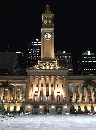
Brisbane City Hall, in Brisbane, Queensland, Australia, is the seat of the Brisbane City Council. It is located adjacent to King George Square, where the rectangular City Hall has its main entrance. The City Hall also has frontages and entrances in both Ann Street and Adelaide Street. The building design is based on a combination of the Roman Pantheon, and St Mark's Campanile in Venice and is considered one of Brisbane's finest buildings. It was listed on the Register of the National Estate in 1978 and on the Queensland Heritage Register in 1992. It is also iconic for its Westminster chimes which sound on the quarter-hour.

<span class="mw-page-title-main">King George Square busway station</span>

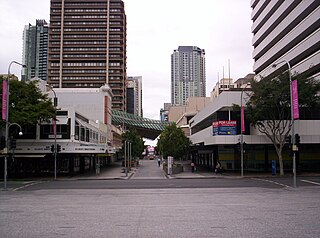
King George Square busway station is located in Brisbane, Queensland, Australia serving the Brisbane central business district. It is located beneath King George Square and marks the start of the Northern Busway. The station has twelve stops on two platforms; access to these platforms is via an underground concourse which can be accessed from Ann Street or Adelaide Street. Passengers wait behind automatic doors on the stop that is assigned to their bus. It opened on 19 May 2008.

<span class="mw-page-title-main">Brisbane central business district</span> Suburb of Brisbane, Queensland, Australia

Brisbane City is the central suburb and central business district of Brisbane, the state capital of Queensland, Australia. It is colloquially referred to as the "Brisbane CBD" or "the city". It is located on a point on the northern bank of the Brisbane River, historically known as Meanjin, Mianjin or Meeanjin in the local Aboriginal Australian dialect. The triangular shaped area is bounded by the median of the Brisbane River to the east, south and west. The point, known at its tip as Gardens Point, slopes upward to the north-west where the city is bounded by parkland and the inner city suburb of Spring Hill to the north. The CBD is bounded to the north-east by the suburb of Fortitude Valley. To the west the CBD is bounded by Petrie Terrace, which in 2010 was reinstated as a suburb.

<span class="mw-page-title-main">Queen Street, Brisbane</span> Street in Brisbanes CBD

<span class="mw-page-title-main">Museum of Brisbane</span> History museum in Brisbane City Hall, King George Square

Museum of Brisbane (MoB) explores contemporary and historic Brisbane, Australia, and its people through a program of art and social history exhibitions, workshops, talks, tours and children's activities. Located on Level 3, of Brisbane City Hall in the city's CBD, the Museum and its staff are highly regarded for their innovation and contemporary international practice across the museum and gallery sector.

<span class="mw-page-title-main">Adelaide Street, Brisbane</span> Street in Brisbane, Queensland

Adelaide Street is a major street in Brisbane, Queensland, Australia. It runs between and parallel to Queen Street and Ann Street.

<span class="mw-page-title-main">Ann Street, Brisbane</span> Street in Brisbane, Queensland

Ann Street runs parallel to Adelaide Street and is the northernmost street in the Brisbane CBD in Queensland, Australia. The street is named for Anne, Queen of Great Britain, as part of the CBD street naming series of female British royalty. It is a major thoroughfare, linking as a four-lane one-way street the suburb of Fortitude Valley in the northeast with the Riverside Expressway in the southwest; house numbers run the opposite direction.

<span class="mw-page-title-main">Albert Street, Brisbane</span> Street in Brisbane, Queensland

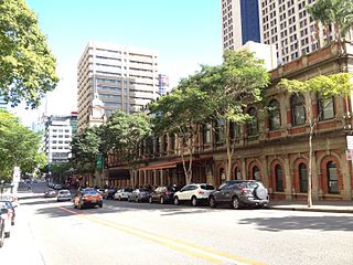
Albert Street is a street in the Brisbane central business district, Queensland, Australia. It was named after Prince Albert, the Prince Consort of Queen Victoria of the United Kingdom. Albert Street railway station is being built directly beneath the street and is expected to open in 2026. The station precinct includes partial road closures as planned in the 2014 City Centre Master Plan, for the creation of a new public space.

<span class="mw-page-title-main">Brisbane Festival Hall</span> Multi-purpose arena located in the Brisbane, Australia

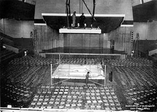
Brisbane Festival Hall was an indoor arena located on the southern corner of Albert Street and Charlotte Street, Brisbane, Queensland, Australia. It operated from 1910 to 2003, before being demolished to make the Oak Festival Towers apartment building and hotel.

<span class="mw-page-title-main">Elizabeth Street, Brisbane</span> Street in Brisbane, Queensland

Elizabeth Street is a major street in the centre of the city in Brisbane, Queensland, Australia. The street was one of the earliest in Brisbane being established at the beginning of settlement in Brisbane as Moreton Bay penal settlement. Today, most of the street is fronted by low-level retail outlets, with an increase in mixed use skyscrapers being recently constructed.

<span class="mw-page-title-main">North Quay, Brisbane</span> Street in Brisbane, Queensland

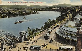
North Quay is a location in the Brisbane central business district and the name of a street in the same area, running along the Brisbane River from an intersection near Makerston Street to the top of the Queen Street mall, linking the Victoria Bridge and the William Jolly Bridge along the river's northern bank. It was the site of Brisbane’s initial settlement, at a point where a stream flowing from Spring Hill provided fresh water, later collected in a reservoir on Tank Street.

<span class="mw-page-title-main">Early Streets of Brisbane</span> Heritage-listed site in Brisbane, Queensland

The Early Streets of Brisbane is a heritage-listed archaeological site at sections of Albert Street, George Street, William Street, North Quay, and Queen's Wharf Road in Brisbane City, City of Brisbane, Queensland, Australia. It was built from 1825 onwards. It was added to the Queensland Heritage Register on 16 July 2010.

<span class="mw-page-title-main">Henry Eli White</span> New Zealand architect (1876–1952)

Henry Eli White, also known as Harry White, was a New Zealand-born architect best known for the many theatres and cinemas he designed in New Zealand and Australia in the 1910s and 1920s. Many of the major surviving historic venues in the two countries are White designs, including the St. James Theatre, Wellington, St. James Theatre, Auckland, the Capitol Theatre and State Theatre in Sydney, and the Palais Theatre and the interiors of the Princess Theatre and Athenaeum Theatre in Melbourne. He also designed the City Hall and the attached Civic Theatre in Newcastle, New South Wales.

<span class="mw-page-title-main">Albert Hall, Brisbane</span> Demolished church hall in Brisbane, Queensland

Albert Hall was a church hall and theatre from 1901 to 1969 in Brisbane, Queensland, Australia. It was on the north side of Albert Street between Ann Street and Turbot Street, to the left of Albert Street Methodist Church. Albert Hall was replaced by the SGIO / Suncorp Building. Although a church hall, its central city location led to a wider range of uses than a typical church hall.

Dance Halls of Brisbane in the twentieth century were popular venues for entertainment, socialising and reflected styles of music, architecture, popular culture and city planning.

<span class="mw-page-title-main">Tivoli Theatre, Brisbane</span>

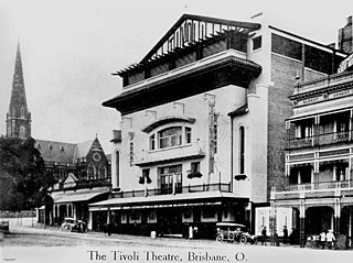
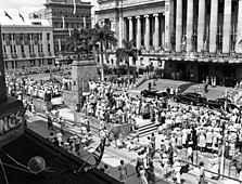
The Tivoli Theatre (Brisbane) operated between 1914 until its closure in 1965 and demolition in 1969. It was situated opposite the Brisbane City Hall, in the site of the present King George Square. This theatre is not related to The Tivoli in Fortitude Valley.

References

  1. "King George Square". Brisbane Heritage Register. Brisbane City Council . Retrieved 31 July 2021.
  2. "Albert Street, showing the King George V monument and fountain before the City Hall, mountains beyond". nla.gov.au. Archived from the original on 3 March 2016. Retrieved 15 April 2018.
  3. "King George V Square and Town Hall, Brisbane". nla.gov.au. Archived from the original on 3 March 2016. Retrieved 15 April 2018.
  4. "Tivoli Theatre and Roof Garden in Brisbane, AU - Cinema Treasures". cinematreasures.org. Retrieved 7 January 2020.
  5. East, John W. (2019). "Urban Improvement in Brisbane between the Wars An Architectural History of the Widening of Adelaide Street 1924 to 1931". espace.library.uq.edu.au. Retrieved 7 January 2020.
  6. Bruce McMahon (22 October 2009). "King George Square revamp sparks mixed reaction". www.couriermail.com.au. Archived from the original on 24 October 2009. Retrieved 13 November 2009.
  7. "King George Square revamp sparks mixed reaction" . Retrieved 14 May 2015.[ permanent dead link ]
  8. Marissa Calligeros (26 October 2012). King George Square too hot to handle Archived 10 October 2012 at the Wayback Machine . Brisbane Times. Fairfax Media. Retrieved on 17 December 2012.
  9. "King George Square designer wouldn't change a thing despite calls to bring back the grass". www.couriermail.com.au. Retrieved 14 May 2015.

27°28′6″S153°1′27″E / 27.46833°S 153.02417°E / -27.46833; 153.02417