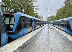
Stockholm metro station | ||||||||||||||||
General information | ||||||||||||||||
Coordinates | 59°20′18″N17°56′22″E / 59.33833°N 17.93944°E | |||||||||||||||
Owned by | Storstockholms Lokaltrafik | |||||||||||||||
Platforms | 1 island platform | |||||||||||||||
Tracks | 2 | |||||||||||||||
Construction | ||||||||||||||||
Structure type | Elevated | |||||||||||||||
Accessible | Yes | |||||||||||||||
Other information | ||||||||||||||||
Station code | BMP | |||||||||||||||
History | ||||||||||||||||
Opened | 26 October 1952 | |||||||||||||||
Passengers | ||||||||||||||||
2019 | 13,400 boarding per weekday [1] | |||||||||||||||
Services | ||||||||||||||||
| ||||||||||||||||
Location | ||||||||||||||||
Brommaplan metro station is a station on the Green line of the Stockholm metro. It is located in the district of Riksby, which is part of the borough of Bromma in the west of the city of Stockholm. The station is elevated and has a single island platform, with access from a lower level station building. [2] [3] [4] The distance to Slussen is 10.5 km (6.5 mi).[ citation needed ]
The station lies on the route of a line known as the Ängbybanan that formerly linked Alvik and Islandstorget. The Ängbybanan, which included the elevated tracks at Brommaplan now used by the metro, was designed and built for use by the future metro, but was operated from 1944 as part of line 11 of the Stockholm tramway. Brommaplan station was inaugurated as part of the metro on 26 October 1952 with the conversion of the Ängbybanan and its extension to form the metro line between Hötorget and Vällingby. [2] [5]
As part of Art in the Stockholm metro project, the station received a composition in glass, stainless sheet metal and aluminium referring to the history of aviation and the nearby Bromma Airport. The artwork was created by Peter Svedberg and installed in 1996 [6]
The Stockholm Metro is a rapid transit system in Stockholm, Sweden. The first line opened in 1950, and today the system has 100 stations in use, of which 47 are underground and 53 above ground. There are three coloured lines, as shown on the tube maps, which form seven numbered routes with different termini. Routes numbered 17, 18 and 19, 13 and 14 and 10 and 11 all go through the centre of the city, resulting in a very centralized system. All three lines and seven routes interchange at T-Centralen station. Apart from this, there are three other interchange between lines, at Fridhemsplan, Slussen and Gamla stan stations.
Tvärbanan is a light-rail line in Stockholm, Sweden. Its name literally translates to The transverse line, as it operates crosswise to the otherwise radial metro and commuter rail lines of Stockholm. It links together several transit lines through its connections with the southern, western and northern subway branches of the Stockholm Metro (Tunnelbana) as well as three branches of the Stockholm commuter rail (Pendeltåg). The possibility to travel between southern, western and northern greater Stockholm without having to enter the city centre significantly reduces the number of transit passengers, also reducing the number of trains having to pass through the Old Town bottleneck during peak hours. Near Liljeholmen the track is shared with freight traffic for a short section, this being the only place in Sweden where freight traffic and trams share the same track.
Nockebybanan is a tram line between Nockeby and Alvik in the western suburbs of Stockholm, Sweden. The 5.6 kilometers (3.5 mi) long line is part of the Storstockholms Lokaltrafik public transport network, and connects with the Stockholm metro and Tvärbanan tram at Alvik metro station. The Nockebybanan, also known as line 12, is operated by Arriva.
Stockholm commuter rail is the commuter rail system in Stockholm County, Sweden. The system is an important part of the public transport in Stockholm, and is controlled by Storstockholms Lokaltrafik. The tracks are state-owned and administered by the Swedish Transport Administration, while the operation of the Stockholm commuter rail services itself has been contracted to MTR Nordic since December 2016.
Transport in Stockholm consists of roads, buses, metro, commuter rail, Inter-city rail, regional rail, light rail, tram, commuter ferry and an archipelago boat operation in Stockholm County, Sweden. The bus and rail is organized by Storstockholms Lokaltrafik, SL, which is owned by the Stockholm County Council. Tickets for all SL services can be purchased most easily in the SL app. For single tickets, just tap a credit card against the turnstiles and on buses. A single ticket is valid for 75 minutes, costs 39 SEK in 2023. The operation and maintenance of the public transport systems are delegated by SL to several contractors. The archipelago boat traffic is handled by Waxholmsbolaget.
Islandstorget is a station in the Stockholm metro on the Green line. It is located in the district of Södra Ängby, which is part of the borough of Bromma in the west of the city of Stockholm. The station is above ground with a single island platform. The entrance is from Blackebergsvägen, which passes over the line. On a workday there are some 3,450 passengers who travel from Islandstorget.
Åkeshov is a station on the Green line of the Stockholm metro. It is located in the borough of Bromma in the west of the city of Stockholm. The station is at ground level, has two island platforms flanking three through tracks, and is one of the intermediate termini along the northern section of the Green line, with line 17 trains normally terminating. Access is by way of a pedestrian underpass that passes under both the metro line and the adjacent Bergslagsvägen street.
Abrahamsberg is a station on the Green line of the Stockholm metro. It is located on the border between the districts of Ulvsunda and Abrahamsberg, which are part of the borough of Bromma in the west of the city of Stockholm. The station is above ground and has a single island platform, with access from underpass carrying Abrahamsbergsvägen under the line.
Vällingby is a station on the Green line of the Stockholm metro. It is located in the district of Vällingby, which is part of the borough of Hässelby-Vällingby in the west of the city of Stockholm. The station is nominally above ground and has a two island platforms and three through tracks, with access from a station building spanning the tracks. This station building forms part of the cultural and retail centre of Vällingby, much of which has subsequently been built over the tracks and platforms of the metro, giving it an underground feel.
Gamla stan is a station on the Green and Red lines of the Stockholm metro. It is located on the western side of the Gamla stan district of central Stockholm, and is at ground level, although partly under the Centralbron bridge that carries road and mainline rail across the waterways that define the centre of the city. The same waterways are responsible for the ground level location of the station, unusual for a city centre metro station, as the lines cross between the islands of Stadsholmen and Södermalm by a bridge immediately south of the station.
Alvik metro station is a station on the Green line of the Stockholm metro, and on the Tvärbanan and Nockebybanan lines of Stockholm tramways. It is located on the border between the districts of Traneberg and Alvik, which are part of the borough of Bromma in the west of the city of Stockholm. The station is one of the intermediate termini along the northern section of the Green line, with line 18 trains normally terminating, and is also the terminus of the Nockebybanan.
Ängbyplan metro station, formerly known as Färjestadsvägen metro station, is a station on the Green line of the Stockholm metro. It is located in the district of Södra Ängby, which is part of the borough of Bromma in the west of the city of Stockholm. The station is above ground and has a single island platform, with access from the underpass taking Färjestadsvägen under the line. The distance to Slussen is 12.4 kilometres (7.7 mi).
Blackeberg metro station is a station on the Green line of the Stockholm metro. It is located in the district of Blackeberg, which is part of the borough of Bromma in the west of the city of Stockholm. The station has a single island platform, with access from a station building spanning the tracks. Two thirds of the platform is located outdoors and one third is located in a rock tunnel under Blackebergsplan. The distance to Slussen is 14.1 km (8.8 mi).
Thorildsplan metro station is a station on the Green line of the Stockholm metro. It takes its name from the nearby park of Thorildsplan, which in turn is named after the writer Thomas Thorild, and is in the district of Kristineberg, which is in the borough of Kungsholmen in central Stockholm. The station has a single island platform and is located in the centre of Drottningholmsvägen, with access from a pedestrian underpass at its eastern end that passes under both road and rail line. The distance to Slussen is 6.1 km (3.8 mi).
Stora Mossen metro station is a station on the Green line of the Stockholm metro. It is located on the border between the districts of Ulvsunda and Stora mossen, which are part of the borough of Bromma in the west of the city of Stockholm. The station is on an embankment and has a single island platform, with access from a pedestrian subway under the line linking Drottningholmsvägen and Stora Mossens Backe. The distance to Slussen is 9 km (5.6 mi).
Råcksta metro station is a station on the Green line of the Stockholm metro. It is located in the district of Råcksta, which is part of the borough of Hässelby-Vällingby in the west of the city of Stockholm. The station is situated on an embankment and has a single island platform, with access from a lower level station building on Jämtlandsgatan. The distance to Slussen is 14.8 km (9.2 mi).
Medborgarplatsen, formerly known as Södra Bantorget, is a station on the Green line of the Stockholm metro. It is situated near to the Medborgarplatsen square in the district of Södermalm in central Stockholm, and lies below Götgatan between its junctions with Noe Arksgränden and Folkungagatan. The station has a single island platform, which is accessed by entrances at the junction of Götgatan with Folkungagatan, and in the Björns trädgård. The distance to Slussen is 0.6 km (0.37 mi).
Hässelby gård metro station is a station on the Green line of the Stockholm metro. It is located in the district of Hässelby gård, which is part of the borough of Hässelby-Vällingby in the west of the city of Stockholm. The station is elevated and has a single island platform, with access from a lower level station building on Hässelby torg. The distance to Slussen is 17.7 km (11.0 mi).
Hässelby Strand metro station is the western terminus of the Green line of the Stockholm metro. It is located in the district of Hässelby strand, which is part of the borough of Hässelby-Vällingby in the west of the city of Stockholm. The station is at ground level and has a single island platform, with two terminal platform tracks and a siding. Access is from Fyrspannsgatan through a building across the end of the platform that also includes shops and apartments. The distance to Slussen is 18.6 km (11.6 mi).
The Green Line is the oldest of the three Stockholm Metro lines. The 41.256-kilometre (25.635 mi) long line comprises a single line north of the city centre, splitting into three branches south of the city centre. The first section of the line opened as a metro in 1950, although some parts of the line date back to the 1930s and were originally used by the Stockholm tramway.