The Strait of Juan de Fuca is a body of water about 96 miles long that is the Salish Sea's main outlet to the Pacific Ocean. The international boundary between Canada and the United States runs down the centre of the Strait.

Vancouver Island is an island in the northeastern Pacific Ocean and part of the Canadian province of British Columbia. The island is 456 km (283 mi) in length, 100 km (62 mi) in width at its widest point, and 32,100 km2 (12,400 sq mi) in total area, while 31,285 km2 (12,079 sq mi) are of land. The island is the largest by area and the most populous along the west coasts of the Americas.
British Columbia Ferry Services Inc., operating as BC Ferries (BCF), is a former provincial Crown corporation, now operating as an independently managed, publicly owned Canadian company. BC Ferries provides all major passenger and vehicle ferry services for coastal and island communities in the Canadian province of British Columbia. Set up in 1960 to provide a similar service to that provided by the Black Ball Line and the Canadian Pacific Railway, which were affected by job action at the time, BC Ferries has become the largest passenger ferry line in North America, operating a fleet of 41 vessels with a total passenger and crew capacity of over 27,000, serving 47 locations on the B.C. coast.

The Strait of Georgia or the Georgia Strait is an arm of the Salish Sea between Vancouver Island and the extreme southwestern mainland coast of British Columbia, Canada, and the extreme northwestern mainland coast of Washington, United States. It is approximately 240 kilometres (150 mi) long and varies in width from 20 to 58 kilometres. Along with the Strait of Juan de Fuca and Puget Sound, it is a constituent part of the Salish Sea.
Port McNeill is a town in the North Island region of Vancouver Island, British Columbia, Canada on Vancouver Island's northeast shore, on Queen Charlotte Strait. Originally a base camp for loggers, it became a settlement in 1936. It was named after Captain William Henry McNeill of the Hudson's Bay Company.

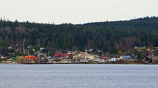
Sointula is an isolated village on Malcolm Island in British Columbia, Canada. Lying between Vancouver Island and the British Columbia mainland, northeast of Port McNeill and not far from Alert Bay, the island is part of the historic and present territory of the ‘Namgis First Nation. At the 2011 census, the village had a population of 576, down 3.0% from the 2006 census.

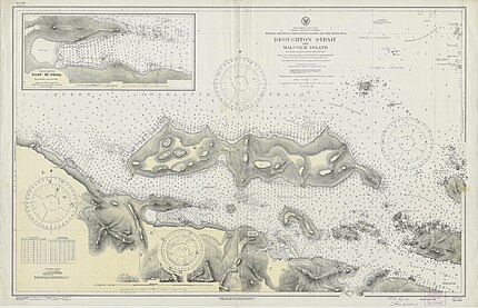
Queen Charlotte Strait is a strait between Vancouver Island and the mainland of British Columbia, Canada. It connects Queen Charlotte Sound with Johnstone Strait and Discovery Passage and via them to the Strait of Georgia and Puget Sound. It forms part of the Inside Passage from Washington to Alaska. The term Queen Charlotte Strait is also used to refer to the general region and its many communities, notably of the Kwakwakaʼwakw peoples. Despite its name, Queen Charlotte Strait does not lie between Haida Gwaii and the mainland; that body of water is named Hecate Strait.

Knight Inlet is one of the principal inlets of the British Columbia Coast, and the largest of the major inlets in the southern part of the Coast. It is fifth in sequence of the great saltwater inlets north from the 49th parallel near Vancouver, but it is the first whose outflow points away from the Strait of Georgia, opening into Queen Charlotte Strait at the Kwakwakaʼwakw community of Memkumlis on Village Island.
Malcolm Island is an island in the Canadian province of British Columbia, located north of Haddington Island in the Queen Charlotte Strait near Vancouver Island. It has ferry access from the Vancouver Island community of Port McNeill. The island is located within the Mount Waddington Regional District.

Alert Bay is a village on Cormorant Island, near the town of Port McNeill on northeast Vancouver Island, in the Regional District of Mount Waddington, British Columbia, Canada.

Broughton Archipelago Provincial Park is the largest marine provincial park located in British Columbia, Canada. The park is located in the Queen Charlotte Strait around 30 km east of Port McNeill, a town situated on Vancouver Island. In terms of its functions, the park offers tourism opportunities such as kayaking and whale watching, preserves a wide array of wildlife including many at-risk species, and has a long history of use by First Nation peoples.

Fanny Bay is an unincorporated community in the Canadian province of British Columbia. It is located on Baynes Sound on the east coast of Vancouver Island. It has a population of 921. It is best known for its fine oysters. The area is served by the Island Highway.
The 'Namgis First Nation is a First Nations band government on northern Vancouver Island in British Columbia, Canada, and on adjoining islands in the southern Queen Charlotte Strait region.
Broughton Archipelago is a group of islands located at the eastern end of Queen Charlotte Strait in Mount Waddington Regional District, British Columbia. The archipelago is the traditional territory of the Musgamagw Dzawada'enuxw, Namgis, Ma'amtagila and Tlowitsis nations of the Kwakwaka'wakw peoples.
Haddington Island is a small volcanic island in the Canadian province of British Columbia, located in the Broughton Strait, and separated from Malcolm Island to the north by the Haddington Passage. It is located in the Mount Waddington Regional District.

Lama Passage, sometimes referred to as Lama Pass, is a strait on the Central Coast of British Columbia, Canada, between Denny, Campbell and Hunter Islands. It is part of the Inside Passage shipping route, connecting Seaforth Channel with Fisher Channel. It was named for a Hudson's Bay Company brigantine, the Lama, under Captain McNeill, which with another HBC vessel, the Dryad under Captain Kipling, brought building materials and stores from Fort Vancouver for the founding of Fort McLoughlin in 1833.
Actaeon Sound is a sound in the Queen Charlotte Strait region of the Central Coast of British Columbia, branching off northeasterly from the north side of Drury Inlet near its head on the mainland of British Columbia to the north of the town of Port McNeill, on the opposite side of Queen Charlotte Strait. On the south side of the sound is the Bond Peninsula at 50°56′50″N127°06′55″W, which is formed by a sidewater, Bond Lagoon at 50°56′34″N127°06′34″W, both presumably named in 1865 by Captain Pender, in association with other Admiralty and HMS Actaeon-related names.
Cormorant Island is an island in Queen Charlotte Strait on the Central Coast of British Columbia, Canada. It has a total land area of about 4 square km and is located south of Malcolm Island and east of Port McNeill.

The Nimpkish River is a river in northern Vancouver Island in British Columbia, Canada. It is the longest river on the Island, rising on the west slope of Mount Alston, flowing northwest into Nimpkish Lake and then north into the Broughton Strait at a point 8 km east of Port McNeill, just southwest of the town of Alert Bay on Cormorant Island.

Broughton Island is an island in the Broughton Archipelago of the Queen Charlotte Strait area of the Central Coast of British Columbia, northwest of Gilford Island.