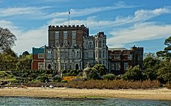
Brownsea Castle, also known historically as Branksea Castle, was originally a Device Fort constructed by Henry VIII between 1545 and 1547 to protect Poole Harbour in Dorset, England, from the threat of French attack. Located on Brownsea Island, it comprised a stone blockhouse with a hexagonal gun platform. It was garrisoned by the local town with six soldiers and armed with eight artillery pieces. The castle remained in use after the original invasion scare had passed and was occupied by Parliament during the English Civil War of the 1640s. By the end of the century, however, it had fallen into disuse.
In 1726 the castle was converted into a private residence by William Benson, despite complaints from the town of Poole. Benson and the subsequent owners extended the original blockhouse to form a country house, landscaping the surrounding island to create ornamental gardens and lakes. The 19th century saw continued building work by the castle's occupants, including the entrepreneur Colonel William Waugh, who erected various Jacobethan-styled extensions. A serious fire in 1896 gutted the castle, which was restored by Major Kenneth Robert Balfour. The wealthy stockbroker Charles Van Raalte led a lavish lifestyle at Brownsea at the start of the 20th century, using it to house his collection of antique musical instruments.
Brownsea Castle was purchased by Mary Bonham-Christie in 1927. She allowed the property to fall into disrepair and by the time of her death in 1961 it was in a very poor condition. It was then purchased by the National Trust and leased to the John Lewis Partnership, who restored it over many years. In the 21st century it is still used by the Partnership as a corporate hotel for their employees and retired staff.
History
16th century
Brownsea Castle was built as a consequence of international tensions between England, France and the Holy Roman Empire in the final years of the reign of King Henry VIII. Traditionally the Crown had left coastal defences to the local lords and communities, only taking a small role in building and maintaining fortifications, and while France and the Empire remained in conflict with one another, maritime raids were common but an actual invasion of England seemed unlikely.[1] Modest defences, based around simple blockhouses and towers, existed in the south-west and along the Sussex coast, with a few more impressive works in the north of England, but in general the fortifications were very limited in scale.[2]
In 1533, Henry then broke with Pope Paul III in order to annul the long-standing marriage to his wife, Catherine of Aragon and remarry.[3] This resulted in France and the Empire declaring an alliance against Henry in 1538, and the Pope encouraging the two countries to attack England.[4] Henry responded in 1539 by ordering, through an instruction called a "device", the construction of fortifications along the most vulnerable parts of the coast. The immediate threat passed, but resurfaced in 1544, with France threatening an invasion across the Channel, backed by her allies in Scotland.[5] Henry therefore issued another device in 1544 to further improve the country's defences, particularly along the south coast.[6]
The castle was built on the south-east corner of Brownsea Island between 1545 and 1547 to protect the entrance of the busy Poole Harbour.[7] The island belonged to the Crown, having been confiscated from Cerne Abbey during the Dissolution of the Monasteries a few years before.[8] It was a conservative design, being a one-storey, square blockhouse, reported in 1552 to be 44 feet (13m) across, able to support guns on its roof and sub-divided into three rooms; the blockhouse was originally intended to have been two storeys in height, but this was not achieved.[9] The blockhouse was surrounded on the seaward side by a hexagonal gun platform, with a moat around the other three sides and a 24-foot-long (7.3m)drawbridge on the south-west side to allow access.[10]
The construction was paid for by a combination of the Crown and the local town of Poole, who took on the responsibility of garrisoning and maintaining it; in the early years of Elizabeth's reign, the normal garrison was described as comprising six men and was equipped with eight artillery pieces.[11]
Additional work on the gun platform costing £56 was carried out in 1548, and further work was carried out in 1552 to develop the castle's defences, at the cost to Poole of £133.[12][lower-alpha 1] The castle needed regular investment: 101 piles were driven in during 1551, probably to combat coastal erosion, and in 1561 the town petitioned the Crown for help with further repairs and the provision of new cannons.[12] Another petition was made for similar help in 1571, resulting in repairs two years later costing £520 and requiring 4,000 tonnes (3,900 long tons; 4,400 short tons) of stone.[12][lower-alpha 1] More work followed in 1585, including building an additional 4-foot-high (1.2m) wall around the castle.[14]
In 1576, Elizabeth I granted the castles of Brownsea and Corfe for life to Sir Christopher Hatton, making him the Admiral of Purbeck.[15] Hatton argued with the town of Poole, claiming that he had the right to search and inspect ships going into Poole Harbour, as well as the rights to the revenues from the local ferry service; he lost his legal case around the ferrying rights in 1581.[16] In 1589, the Bountiful Gift refused to pull in for inspection, arguing that it had had a valid pass to leave, and Brownsea Castle fired on the vessel, killing two of the crew.[17] The castle's captain, Walter Partridge, was tried and convicted of manslaughter, but ultimately pardoned.[18] The rest of the island, but not the castle, was leased out to various landowners over the next few years.[19]
17th - 18th centuries
1818 view of the castle, showing the Palladian development of the original blockhouse by Sir Humphrey Sturt
The castle was garrisoned throughout most of the 17th century.[14] In the civil war of the 1640s between the supporters of Charles I and Parliament, the castle was held for Parliament, under the control of the Governor of Poole.[20] The castle was refortified and in 1644, Parliament ordered that four pieces of artillery and four chests of muskets be sent to the castle, which by 1646 had a garrison of 20 men.[21] During the Interregnum, the wealthy merchant Sir Robert Clayton bought the surrounding island.[22] Clayton probably did not live in the castle, however, and it fell into disrepair; by the end of the century the town of Poole refused to garrison the decaying defences.[23]
The amateur architect William Benson bought the island from Clayton's heirs in 1726 for £300.[24][lower-alpha 2] Benson set about converting the castle into a private residence, amid complaints from the authorities in Poole.[26] The town took the matter to the Attorney General, where they argued that Benson had not bought the rights to the castle itself, only the island, and that the castle was a national fortification, originally built by Henry VIII and owned by Poole.[26] Benson argued that the building had not originally been a castle but rather a lodging house; it had not been built by Henry and therefore the Crown had no particular rights over it - rather, the previous owners of the island had simply allowed the town and the government to place artillery there.[26] The matter was eventually dropped and Benson demolished the external fortifications, created a Great Hall and planted trees and rare plants around the island.[27]
The castle was sold to a Mr Chamberlayne and then onto Sir Gerard Sturt in 1762 and Gerard's cousin, Sir Humphrey Sturt, in 1765.[28] Humphrey extended the castle around its 16th century core to form a Palladian styled, four-storey tower with battlements, with new wings stretching away on three sides.[14] He also built a walled courtyard with hot houses beside the castle, and landscaped the island with two lakes and a large number of fir trees at a cost of £50,000.[29] His son, Charles Sturt, made the castle his primary home, although he was often living elsewhere as a result of his involvement in the Napoleonic Wars.[30]
Charles Sturt's son, also called Charles, inherited the property and sold it to Sir Charles Chad in 1817.[31] Chad invested significantly in the castle and Prince George visited in 1818, arriving to a salute from the castle guns.[31] The diplomat Sir Augustus Foster acquired the castle in 1840 on his retirement; he committed suicide at the castle in 1848, having been in what his inquest termed a state of temporary insanity following a "disease of the heart and lungs".[32]
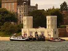
A retired Indian Army officer, Colonel William Waugh, bought the island in 1852, hoping to turn it into a profitable pottery works.[33] He carried out restoration work on the castle and built up a new Jacobethan-styled range around the south and east sides of the castle.[31] Waugh also constructed the crenelated gatehouse and clocktower at the entrance to the courtyard, and the Jacobethan-styled family pier by the sea below the castle.[14] The commercial venture was a failure and Waugh fled his creditors to Spain in 1857.[33]
After a period of ownership by a Mr Faulkner, who continued the pottery scheme, the property was eventually resold in 1873 to the politician and lawyer George Cavendish-Bentinck for £30,000, who furnished the castle with an extensive collection of Italian Renaissance sculpture.[34][lower-alpha 3] Cavendish-Bentinck closed the pottery works and gave the island as a family home to his son, William, paying for the castle to be extensively renovated; William and his wife Ruth moved into it in 1888.[35] Cavendish-Bentinck died in 1891 with extensive debts, forcing William to sell the castle and island to Major Kenneth Robert Balfour.[36]
After the installation of new-fangled electric lighting, the castle caught fire on 26 January 1896 and the interiors were gutted by the blaze.[37][38][39] Balfour rebuilt the property with the services of the architect Philip Brown, softening the more complex aspects of the castle's design.[40] Balfour's wife, Margaret Anne, fell ill and he decided to sell the island in 1901 to the stockbroker Charles van Raalte.[41]
20th century
The Family Pier, also dating from 1852
In 1901 the island was bought by the stockbroker Charles van Raalte, who maintained a lavish lifestyle at the castle, which by now had 38 bedrooms. The van Raaltes held grand house-parties during the summer months, complete with servants and a part-time musical band. They assembled a rare collection of around 250 historical musical instruments from Europe, Asia and Africa at the castle.[42]
Charles van Raalte died in 1908 but his wife Florence stayed until 1925.[43] On Florence's death in 1927 the castle was sold to Sir Arthur Wheeler, who promptly decided to auction off the remaining contents with the intent of demolishing the property.[44] The sale, which included some of Van Raalte's collection of instruments, paintings and a 5,000 book library, produced £22,300.[45][lower-alpha 3]
The castle was not demolished as planned and instead was purchased by Mary Bonham-Christie for £125,000 later that year.[46][lower-alpha 3] She decided to live in a nearby house rather than in the castle itself, allowing the island to return to nature and the castle to fall into disrepair.[47]
1932 was the Silver Jubilee of that first Camp, and Mrs Bonham Christie permitted celebrations to be held on the Island, and 500 Scouts camped on the original site. Two years later, in 1934, a bush-fire broke out, raged for three days and caused enormous damage.[48][49]
By the time of Bonham-Christie's death in 1961 the roof of the castle had partially collapsed and a tree was growing up through the centre of the building.[50] Facing large death duties, Bonham-Christie's grandson proposed to build 400 luxury houses on the island, but this caused such an outcry that the proposal was refused. HM Treasury agreed to accept it in lieu of death duty.[51] However, HM Treasury deals only in money, so offered the Island to the National Trust for £100,000. The National Trust could only raise £25,000, so the remaining £75,000 was raised equally by the Boy Scout & Girl Guide Movements, by the forerunner of the Dorset WildLife Trust, who took over management of the North half the island, and by the John Lewis Partnership, who bought a 99-year repairing lease of the Castle and gardens for use as a corporate hotel by their employees, they gradually restored the buildings in stages and they remain the current tenants.[52]
The National Trust took ownership of the castle and island in 1962 but considered the castle to be of "little antiquity or architectural interest".[53] Some of the 19th century interior features still survive, including wood panelling and ornamental ceilings, with some carved stone fireplaces from Venice; the castle also has four cannons, probably dating from the 17th or early 18th century.[54] The castle is protected under UK law as a Grade II listed building.[55]
Notes
1 2 Comparing early modern costs and prices with those of the modern period is challenging. £56 in 1548 could be equivalent to between £27,000 and £12 million in 2014, depending on the price comparison used. £133 in 1552 could be equivalent to between £43,000 and £21 million, and £520 in 1571 between £158,000 and £62 million. For comparison, the total royal expenditure on all the Device Forts across England between 1539–47 came to £376,500, with St Mawes, for example, costing £5,018, and Sandgate £5,584.[13]
↑ Comparing early modern costs and prices with those of the modern period is challenging. £300 in 1726 could be worth between £40,000 and £5.4 million in 2014 terms, depending on the measure used. £50,000 in 1765 could be worth between £6.3 million and £657 million.[25]
1 2 3 £30,000 in 1873 could be worth between £2.6 million and £42 million in 2014 terms, depending on the measure used. £125,000 in 1927 could be worth between £6.7 million and £50 million in 2014 terms, depending on the measure used, £22,000 between £1.2 million and £8.9 million.[25]
Related Research Articles
Dorset is a ceremonial county in South West England. It is bordered by Somerset to the north-west, Wiltshire to the north and the north-east, Hampshire to the east, the Isle of Wight across the Solent to the south-east, the English Channel to the south, and Devon to the west. The largest settlement is Bournemouth, and the county town is Dorchester.
Poole is a coastal town and seaport on the south coast of England in the Bournemouth, Christchurch and Poole unitary authority area in Dorset, England. The town is 21 miles (34 km) east of Dorchester and adjoins Bournemouth to the east. Since 1 April 2019, the local authority is Bournemouth, Christchurch and Poole Council. The town had an estimated population of 151,500 making it the second-largest town in the ceremonial county of Dorset. Together with Bournemouth and Christchurch, the conurbation has a total population of nearly 400,000.
Brownsea Island is the largest of the islands in Poole Harbour in the county of Dorset, England. The island is owned by the National Trust with the northern half managed by the Dorset Wildlife Trust. Much of the island is open to the public and includes areas of woodland and heath with a wide variety of wildlife, together with cliff top views across Poole Harbour and the Isle of Purbeck.
Studland is a village and civil parish on the Isle of Purbeck in Dorset, England. The village is located about 2 miles (3.2 km) north of the town of Swanage, over a steep chalk ridge, and 3 miles (4.8 km) south of the South East Dorset conurbation at Sandbanks, from which it is separated by Poole Harbour. The parish includes Brownsea Island within the harbour. In the 2011 census the parish had 182 households and a population of 425, though many of the houses in the village are holiday homes, second homes, or guest houses, and the village's population varies depending upon the season.
Poole Harbour is a large natural harbour in Dorset, southern England, with the town of Poole on its shores. The harbour is a drowned valley (ria) formed at the end of the last ice age and is the estuary of several rivers, the largest being the Frome. The harbour has a long history of human settlement stretching to pre-Roman times. The harbour is extremely shallow, with one main dredged channel through the harbour, from the mouth to Holes Bay.
The Isle of Purbeck is a peninsula in Dorset, England. It is bordered by water on three sides: the English Channel to the south and east, where steep cliffs fall to the sea; and by the marshy lands of the River Frome and Poole Harbour to the north. Its western boundary is less well defined, with some medieval sources placing it at Flower's Barrow above Worbarrow Bay. John Hutchins, author of The History and Antiquities of the County of Dorset, defined Purbeck's western boundary as the Luckford Lake stream, which runs south from the Frome. According to writer and broadcaster Ralph Wightman, Purbeck "is only an island if you accept the barren heaths between Arish Mell and Wareham as cutting off this corner of Dorset as effectively as the sea." The most southerly point is St Alban's Head.
Purbeck was a local government district in Dorset, England. The district was named after the Isle of Purbeck, a peninsula that forms a large proportion of the district's area. However, it extended significantly further north and west than the traditional boundary of the Isle of Purbeck which is the River Frome. The district council was based in the town of Wareham, which is itself north of the Frome.
Steep Holm is an English island lying in the Bristol Channel. The island covers 48.87 acres (19.78 ha) at high tide, expanding to 63.26 acres (25.60 ha) at mean low water. At its highest point it is 78 metres (256 ft) above mean sea level. Administratively it forms part of the unitary authority of North Somerset within the ceremonial county of Somerset; between 1 April 1974 and 1 April 1996, it was administered as part of Avon. Nearby is Flat Holm island, part of Wales.
The Device Forts, also known as Henrician castles and blockhouses, were a series of artillery fortifications built to defend the coast of England and Wales by Henry VIII. Traditionally, the Crown had left coastal defences in the hands of local lords and communities but the threat of French and Spanish invasion led the King to issue an order, called a "device", for a major programme of work between 1539 and 1547. The fortifications ranged from large stone castles positioned to protect the Downs anchorage in Kent, to small blockhouses overlooking the entrance to Milford Haven in Pembrokeshire, and earthwork bulwarks along the Essex coast. Some forts operated independently, others were designed to be mutually reinforcing. The Device programme was hugely expensive, costing a total of £376,000 ; much of this was raised from the proceeds of the Dissolution of the Monasteries a few years before.
The Brownsea Island Scout camp was the site of a boys' camping event on Brownsea Island in Poole Harbour, southern England, organised by Lieutenant-General Baden-Powell to test his ideas for the book Scouting for Boys. Boys from different social backgrounds participated from 1 to 8 August 1907 in activities around camping, observation, woodcraft, chivalry, lifesaving and patriotism. The event is regarded as the origin of the worldwide Scout movement.
Green Island is an island in Poole Harbour in the English county of Dorset. It lies in the central south part of the harbour, south of Brownsea Island and Furzey Island. The island is an Area of Outstanding Natural Beauty (AONB), Site of Special Scientific Interest (SSSI), and Special Protection Area (SPA).
Marcus Noel van Raalte was a British racing driver and playboy.
Abels Shipbuilders Ltd was a ship and boat builder in Bristol, England. In addition to boat building, the company branched out into architectural sculptures, tidal energy and marine restoration, but closed in 2016.
The history of Poole, a town in Dorset, England, can be traced back to the founding of a settlement around Poole Harbour during the Iron Age. The town now known as Poole was founded on a small peninsula to the north of the harbour. Poole experienced rapid growth as it became an important port following the Norman Conquest of England.
The Dorset Heaths form an important area of heathland within the Poole Basin in southern England. Much of the area is protected.
The 1904 East Dorset by-election was a Parliamentary by-election held on 16 March 1904. The constituency returned one Member of Parliament (MP) to the House of Commons of the United Kingdom, elected by the first past the post voting system.
B-P's footprint is a casting, usually in bronze or brass, of the right foot of Lord Baden-Powell, the founder of the Scout and Guide Movements, who is known as "B-P." The idea is that people may put their foot into this casting, so that they can say that they have "walked in the footsteps of B-P."
The Custom House is a Grade II* listed building in Poole, Dorset, England. It is a Georgian building located in the oldest part of Poole Quay, and is currently used as a restaurant.
St Mary's Church is a Church of England parish church at Brownsea Island, Dorset, England. The church was built in 1853–54 and is a Grade II* listed building.
↑ Harrington 2007, p.8; Garnett 2005, p.5; Royal Commission on Historical Monuments (England) (1970), "Studland", British History Online, archived from the original on 16 July 2015, retrieved 13 July 2015
↑ Harrington 2007, p.33; Sydenham 1839, p.389; Royal Commission on Historical Monuments (England) (1970), "Studland", British History Online, archived from the original on 16 July 2015, retrieved 13 July 2015
1 2 3 Sydenham 1839, pp.389–390; Royal Commission on Historical Monuments (England) (1970), "Studland", British History Online, archived from the original on 16 July 2015, retrieved 13 July 2015
1 2 3 4 Royal Commission on Historical Monuments (England) (1970), "Studland", British History Online, archived from the original on 16 July 2015, retrieved 13 July 2015
↑ Garnett 2005, p.7; Van Raalte 1905, p.192; Royal Commission on Historical Monuments (England) (1970), "Studland", British History Online, archived from the original on 16 July 2015, retrieved 13 July 2015
↑ Garnett 2005, p.7; Royal Commission on Historical Monuments (England) (1970), "Studland", British History Online, archived from the original on 16 July 2015, retrieved 13 July 2015; "A History of Brownsea Island", National Trust, 2015, archived from the original on 16 July 2015, retrieved 14 July 2015
↑ "Brownsea Island's Half Century Haven Marked", BBC News, 17 May 2013, archived from the original on 27 July 2013; "Listing", Historic England, archived from the original on 30 October 2021, retrieved 13 July 2015; Royal Commission on Historical Monuments (England) (1970), "Studland", British History Online, archived from the original on 16 July 2015, retrieved 13 July 2015
↑ "Listing", Historic England, archived from the original on 30 October 2021, retrieved 13 July 2015
Bibliography
Anonymous (1927). "A Musician's Paradise". The Musical Times. 68 (1008): 162.
Biddle, Martin; Hiller, Jonathon; Scott, Ian; Streeten, Anthony (2001). Henry VIII's Coastal Artillery Fort at Camber Castle, Rye, East Sussex: An Archaeological Structural and Historical Investigation. Oxford, UK: Oxbow Books. ISBN0904220230.
Garnett, Oliver (2005) [1993]. Brownsea Castle (correcteded.). Swindon, UK: The National Trust. ISBN978-1-84359-110-8.
Graubard, Margaret E. M. (2008). In the Best Society. Bloomington, US: iUniverse. ISBN9780595498314.
Hale, John R. (1983). Renaissance War Studies. London, UK: Hambledon Press. ISBN0907628176.
Harrington, Peter (2007). The Castles of Henry VIII. Oxford, UK: Osprey Publishing. ISBN9781472803801.
King, D. J. Cathcart (1991). The Castle in England and Wales: An Interpretative History. London, UK: Routledge Press. ISBN9780415003506.
Legg, Rodney (1986). Brownsea: Dorset's Fantasy Island. Sherborne, UK: The Dorset Publishing Company. ISBN0902129740.
Morley, B. M. (1976). Henry VIII and the Development of Coastal Defence. London, UK: Her Majesty's Stationery Office. ISBN0116707771.
Sydenham, John (1839). History of the Town and Country of Poole. Poole, UK: Sydenham. OCLC5842224.
Saunders, Andrew (1989). Fortress Britain: Artillery Fortifications in the British Isles and Ireland. Liphook, UK: Beaufort. ISBN1855120003.
Thompson, M. W. (1987). The Decline of the Castle. Cambridge, UK: Cambridge University Press. ISBN1854226088.
Urban, Sylvanus (1848). The Gentleman's Magazine. Vol.30. London, UK: John Boyers Nichols and Son. OCLC1570611.
Van der Straeten, E. (1927). "Sale of the van Raalte Collection of Old Instruments". The Musical Times. 68 (1014): 712.
Van Raalte, Charles (1905). "Brownsea Island". Proceedings of the Dorset Natural History and Archaeological Society. 26: 187–194.
This page is based on this Wikipedia article Text is available under the CC BY-SA 4.0 license; additional terms may apply. Images, videos and audio are available under their respective licenses.


