Gravesend Blockhouse

Last updated

Gravesend Blockhouse
Gravesend, Kent
Remains of Gravesend Blockhouse.jpg
Foundations of Gravesend Blockhouse
Kent UK location map.svg
Red pog.svg
Gravesend Blockhouse
Coordinates 51°26′41″N0°22′22″E / 51.44463°N 0.37277°E / 51.44463; 0.37277
Type Device Fort
Site information
ConditionFoundations remain
Site history
MaterialsBrick and stone

Gravesend Blockhouse was an artillery fortification constructed as part of Henry VIII's Device plan of 1539, in response to fears of an imminent invasion of England by European countries. It was built at Gravesend in Kent at a strategic point along the River Thames and was operational by 1540. A two-storey, D-shaped building built from brick and stone, it had a circular bastion overlooking the river and gun platforms extending out to the east and west. It functioned in conjunction with Tilbury Fort on the other side of the river, and was repaired in 1588 to deal with the threat of Spanish invasion, and again in 1667 when the Dutch navy raided the Thames. A 1778 report recommended alterations to the blockhouse and its defences, leading to the remodelling of the gun platforms and the construction of the new, larger New Tavern Fort alongside it. In the 1830s the government decided to rely entirely on the newer fort and the old blockhouse was demolished in 1844. Its remains were uncovered in archaeological excavations between 1975 and 1976.

Contents

16th century

Background

Gravesend Blockhouse was built as a consequence of international tensions between England, France and the Holy Roman Empire in the final years of the reign of King Henry VIII. Traditionally the Crown had left coastal defences to the local lords and communities, only taking a modest role in building and maintaining fortifications, and while France and the Empire remained in conflict with one another, maritime raids were common but an actual invasion of England seemed unlikely. [1] Modest defences, based around simple blockhouses and towers, existed in the south-west and along the Sussex coast, with a few more impressive works in the north of England, but in general the fortifications were very limited in scale. [2]

In 1533, Henry then broke with Pope Paul III in order to annul the long-standing marriage to his wife, Catherine of Aragon and remarry. [3] Catherine was the aunt of Charles V, the Holy Roman Emperor, and he took the annulment as a personal insult. [4] This resulted in France and the Empire declaring an alliance against Henry in 1538, and the Pope encouraging the two countries to attack England. [5] An invasion of England now appeared certain. [6]

Device of 1539

Henry issued an order, called a "device", in 1539, giving instructions for the "defence of the realm in time of invasion" and the construction of forts along the English coastline. [7] Under this programme of work the River Thames was protected with a mutually reinforcing network of blockhouses at Gravesend, Milton, and Higham on the south side of the river, and Tilbury and East Tilbury on the opposite bank. [8]

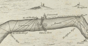
The fortifications were strategically placed. London and the newly constructed royal dockyards of Deptford and Woolwich were vulnerable to seaborne attacks arriving up the Thames estuary, which was then a major maritime route, with 80 percent of England's exports passing through it. [9] The village of Milton and the adjacent town of Gravesend, only 500 metres (1,600 ft) apart, formed a particularly important communications point along the river. [10] They were the centre for the "Long Ferry" traffic of passengers into the capital, and for the "Cross Ferry" over the river to Tilbury, resulting in the local riverbank becoming lined with wharfs. [11] This was also the first point that an invasion force would be able to easily disembark along the Thames, as before this point the mudflats along the sides of the estuary would have made landings difficult. [12]

Construction

Plan of the blockhouse, after 1715 diagram Device fort plans black and white Gravesend, Kent.png
Plan of the blockhouse, after 1715 diagram

Gravesend Blockhouse was designed by the Clerk of the King's Works, James Nedeham, and the Master of Ordnance, Christopher Morice, with Robert Lorde serving as the paymaster for the project and Lionel Martin, John Ganyn and Mr Travers acting as the local overseers. [13] The Crown bought the land for the fort, along with the space for Gravesend Blockhouse, from William Burston for £66; it is uncertain how much the building work cost, but earlier estimates in 1539 had suggested that it would cost £211 to build such a blockhouse, including the 150,000 bricks and quantities of stone, chalk, lime, timber and labour that would be needed. [14] [lower-alpha 1] The work was quickly completed, and by 1540 the blockhouse was fully operational. [13]

It was approximately 28 by 21 metres (92 by 69 ft) in size, two storeys tall, forming a D-shape, with a circular bastion at the front, extending into the Thames; another circular bastion jutted out from the side of the fort. [16] The bulk of the building was made of brick, faced with ashlar stone, with external walls 2 metres (6 ft 7 in) thick. [17] Two walls ran alongside either side of the blockhouse, parallel with the river, forming part of the adjacent platforms for mounting additional guns; in 1600, the east platform was described as being 100 feet (30 m) long and 14 feet (4.3 m) wide. [18] The rear of the blockhouse was overlooked by higher ground and would have been hard to defend. [19]

The fort was initially commanded by Captain James Crane, with a garrison of ten men, including his second in command, a porter, six gunners and two soldiers. [20] As time went on, not all of the gunners worked full-time at the fort, some living and working in the town itself. [20] It is uncertain how many artillery pieces the blockhouse was initially equipped with, although it is known that the five blockhouses along the Thames had 108 brass and iron guns in total between them in 1540. [21]

Use

Engraving from 1588 showing the defences along the River Thames, including Gravesend Blockhouse (centre) and the boom Gravesend defences 1588 Thamesis Descriptio.png
Engraving from 1588 showing the defences along the River Thames, including Gravesend Blockhouse (centre) and the boom

In 1553, orders were issued for the artillery pieces to be removed from Gravesend Blockhouse and taken to the Tower of London, although the historian Victor Smith casts doubt on whether this was actually carried out. [22] In 1588, however, there was a renewed threat of invasion, this time from Spain; the Spanish Armada sailed from A Coruña, while a separate invasion force was prepared in Flanders, threatening London; Rober Dudley, the Earl of Leicester was put in charge of the defences along the Thames. [19]

When Dudley inspected the blockhouse, Gravesend was found to be in poor condition. [19] The gun platforms were unable to bear the weight of cannons, and the defences needed additional artillery and gunpowder; the permanent garrison by now only comprised five gunners. [19] One estimate that summer suggested that 1,000 feet (300 m) of structural timber, 300 iron spikes and 10 cartloads of smaller pieces of timber were needed for the repairs. [23]

Plans were made to seal off the river with a chain or a boom stretching between the blockhouse and Tilbury Fort on the other bank, which was eventually accomplished at a cost of £305. [24] [lower-alpha 1] Further work was carried out on the defences, possibly including raising earthworks and establishing watch-houses. [23] Fears of an invasion persisted for many years afterwards and in 1598 Charles Howard, the Lord High Admiral, expressed his concerns about the effectiveness of the Gravesend Blockhouse in protecting the Thames. [23]

17th century

Blockhouse in the 17th century Cornelis Bol. The Blockhouse in Gravesend.png
Blockhouse in the 17th century

A 1600 survey showed 10 pieces of artillery to be ineffective, while the gun platforms on either side of the fort were in bad condition and 2,828 feet (862 m) of planking, 650 joists and over 19 cartloads of other timber was needed for the repairs. [25] Little investment was forthcoming under James I or Charles I and by 1630 the garrison's pay was in arrears, with the fort was in need of repairs estimated at £1,248. [26] [lower-alpha 2] In 1631 the blockhouse was equipped with two brass demi-culverins and sakers, and an iron culverin, six demi-culverins, four sakers and one minion; the brass guns, which were needed for naval units, were exchanged for iron weapons in 1635. [28]

In 1642 civil war broke out between the supporters of King Charles I and those of Parliament. Gravesend was controlled by Parliament, who placed it under the command of a military governor who oversaw both this fort and Tilbury, and was used to control traffic entering London and to search for spies. [29] Charles II regained the throne in 1660 and was petitioned by several royalists who claimed that they should be restored to the command of the blockhouse; William Leonard was ultimately successful. [30] The defences were repaired and may have been occasionally used by the King as a banqueting hall. [30]

The Dutch fleet raided up the Thames in June 1667, but did not approach Gravesend Blockhouse due to the threat posed by its guns. [31] The fort, under the command of Sir John Griffith, was in reality not well prepared for war. [32] £400 was spent on upgrading the blockhouse, artillery was sent from the Tower of London to reinforce the local guns and four infantry companies were detached to guard the site. [30] [lower-alpha 2] The risk of attack ended with the signing of the Peace of Breda that July, and the blockhouse did not see action. [32] Shortly after the Dutch raids, Sir John was removed from his post for apparently demanding payments from ships passing by the blockhouse, a complaint which was repeated in later years under subsequent captains. [32]

18th–19th centuries

Sir Thomas Page Captain Sir Thomas Hyde Page (1746-1821) by James Northcote.jpeg
Sir Thomas Page

By the start of the 18th century a complex of building had grown up around the original blockhouse, which now had a pier, a dock and two wharfs alongside it, and a large house built by the King's brother, James the Duke of York, after his return to England, as well as the two lines of approximately 20 guns stretching on either side along the river; it had a garrison of a sergeant, 20 soldiers and a gunner on loan from Tilbury Fort. [33] The blockhouse itself was no longer used to mount guns but instead acted as the magazine for the wider fortification, being able to store 2,500 barrels of gunpowder. [34] Under the terms of the Peace of Utrecht in 1713, the number of artillery pieces was reduced to ten, and a survey in 1766 reported that Gravesend was in good condition and equipped with ten 9 lb guns. [35]

Amid rising concerns over the threat of a French invasion, Sir Thomas Page surveyed the blockhouse in 1778 and concluded that its guns were too closely packed together and that they could not easily fire down-river, proposing that a larger fort be built along the Thames to the east to rectify this problem. [36] New Tavern Fort was constructed shortly afterwards and the eastern Gravesend Blockhouse gun platform was redesigned and extended as part of the work. [37] Two volunteer militia companies were established in 1794 and 1797 to support the blockhouse and in 1805 it was equipped with 19 32 lb guns. [38]

Concerns continued to be raised that the blockhouse's guns could not fire downriver and by the 1830s it had been decided to focus investment on the New Tavern and Tilbury forts. [38] The blockhouse itself fell out of use as a magazine in 1834, being briefly used as a government store, and the adjacent gun platforms were sold off in 1835. [38] The blockhouse building was subsequently demolished in 1844. [39]

20th–21st centuries

The site of the former Gravesend Blockhouse was excavated in 1975 and 1976 by the Kent Archaeological Society, uncovering parts of the original building. [40] The site, which lies in the grounds of the Clarendon Royal Hotel, was protected under UK law as a scheduled monument in 1979. [41]

Notes

  1. 1 2 Comparing 16th century costs and prices with those of the modern period is challenging. £66 in 1539 could be equivalent to between £37,200 and £16,940,000 in 2014, depending on the price comparison used. £211 in 1539 could equate to between £118,900 and £54,140,000, while £304 in 1553 to between £109,200 and £44,580,000. For comparison, the total royal expenditure on all the Device Forts across England between 1539–47 came to £376,500, with St Mawes, for example, costing £5,018, and Sandgate £5,584. [15]
  2. 1 2 Comparing 17th century costs and prices with those of the modern period is difficult. £1,248 in 1630 could be equivalent to between £182,300 and £58,720,000 in 2014 terms, depending on the price comparison used. £400 in 1667 could be equivalent to between £56,140 and £11,330,000. [27]

Related Research Articles

<span class="mw-page-title-main">Tilbury Fort</span> Fortification in England

Tilbury Fort, also known historically as the Thermitage Bulwark and the West Tilbury Blockhouse, is an artillery fort on the north bank of the River Thames in England. The earliest version of the fort, comprising a small blockhouse with artillery covering the river, was constructed by King Henry VIII to protect London against attack from France as part of his Device programme. It was reinforced during the 1588 Spanish Armada invasion scare, after which it was reinforced with earthwork bastion, and Parliamentary forces used it to help secure the capital during the English Civil War of the 1640s. Following naval raids during the Anglo-Dutch Wars, the fort was enlarged by Sir Bernard de Gomme from 1670 onwards to form a star-shaped defensive work, with angular bastions, water-filled moats and two lines of guns facing onto the river.

<span class="mw-page-title-main">Deal Castle</span> 16th century artillery fort in Kent, England

Deal Castle is an artillery fort constructed by Henry VIII in Deal, Kent, between 1539 and 1540. It formed part of the King's Device programme to protect against invasion from France and the Holy Roman Empire, and defended the strategically important Downs anchorage off the English coast. Comprising a keep with six inner and outer bastions, the moated stone castle covered 0.85 acres (0.34 ha) and had sixty-six firing positions for artillery. It cost the Crown a total of £27,092 to build the three castles of Deal, Sandown and Walmer, which lay adjacent to one another along the coast and were connected by earthwork defences. The original invasion threat passed but, during the Second English Civil War of 1648–49, Deal was seized by pro-Royalist insurgents and was only retaken by Parliamentary forces after several months' fighting.

<span class="mw-page-title-main">Device Forts</span> Artillery fortifications built to defend the southern coast of England by Henry VIII

The Device Forts, also known as Henrician castles and blockhouses, were a series of artillery fortifications built to defend the coast of England and Wales by Henry VIII. Traditionally, the Crown had left coastal defences in the hands of local lords and communities but the threat of French and Spanish invasion led the King to issue an order, called a "device", for a major programme of work between 1539 and 1547. The fortifications ranged from large stone castles positioned to protect the Downs anchorage in Kent, to small blockhouses overlooking the entrance to Milford Haven in Pembrokeshire, and earthwork bulwarks along the Essex coast. Some forts operated independently, others were designed to be mutually reinforcing. The Device programme was hugely expensive, costing a total of £376,000 ; much of this was raised from the proceeds of the Dissolution of the Monasteries a few years before.

<span class="mw-page-title-main">Yarmouth Castle</span> English artillery fort

Yarmouth Castle is an artillery fort built by Henry VIII in 1547 to protect Yarmouth Harbour on the Isle of Wight from the threat of French attack. Just under 100 feet (30 m) across, the square castle was initially equipped with 15 artillery guns and a garrison of 20 men. It featured an Italianate "arrow-head" bastion on its landward side; this was very different in style from the earlier circular bastions used in the Device Forts built by Henry and was the first of its kind to be constructed in England.

<span class="mw-page-title-main">Sandgate Castle</span> British fort

Sandgate Castle is an artillery fort originally constructed by Henry VIII in Sandgate in Kent, between 1539 and 1540. It formed part of the King's Device programme to protect England against invasion from France and the Holy Roman Empire, and defended a vulnerable point along the coast. It comprised a central stone keep, with three towers and a gatehouse. It could hold four tiers of artillery, and was fitted with a total of 142 firing points for cannon and handguns.

<span class="mw-page-title-main">Garrison Point Fort</span>

Garrison Point Fort is a former artillery fort situated at the end of the Garrison Point peninsula at Sheerness on the Isle of Sheppey in Kent. Built in the 1860s in response to concerns about a possible French invasion, it was the last in a series of artillery batteries that had existed on the site since the mid-16th century. The fort's position enabled it to guard the strategic point where the River Medway meets the Thames. It is a rare example of a two-tiered casemated fort – one of only two of that era in the country – with a design that is otherwise similar to that of several of the other forts along the lower Thames. It remained operational until 1956 and is now used by the Sheerness Docks as a port installation.

<span class="mw-page-title-main">New Tavern Fort</span>

New Tavern Fort is an historic artillery fort in Gravesend, Kent. Dating mostly from the 18th and 19th centuries, it is an unusually well-preserved example of an 18th-century fortification and remained in use for defensive purposes until the Second World War. It was built during the American War of Independence to guard the Thames against French and Spanish raiders operating in support of the newly formed United States of America. It was redesigned and rebuilt in the mid-19th century to defend against a new generation of iron-clad French warships.

<span class="mw-page-title-main">Shornemead Fort</span>

Shornemead Fort is a now-disused artillery fort that was built in the 1860s to guard the entrance to the Thames from seaborne attack. Constructed during a period of tension with France, it stands on the south bank of the river at a point where the Thames curves sharply north and west, giving the fort long views up and downriver in both directions. It was the third fort constructed on the site since the 18th century, but its location on marshy ground led to major problems with subsidence. The fort was equipped for a time with a variety of large-calibre artillery guns which were intended to support two other nearby Thamesside forts. However, the extent of the subsidence meant that it became unsafe for the guns to be fired and the fort was disarmed by the early 20th century.

<span class="mw-page-title-main">Coalhouse Fort</span> Artillery fort at Coalhouse Point in Essex, England

Coalhouse Fort is an artillery fort in the eastern English county of Essex. It was built in the 1860s to guard the lower Thames from seaborne attack. It stands at Coalhouse Point on the north bank of the river, at a location near East Tilbury which was vulnerable to raiders and invaders. It was the last in a series of fortifications dating back to the 15th century and was the direct successor to a smaller mid-19th century fort built on the same site. Constructed during a period of tension with France, its location on marshy ground caused problems from the start and led to a lengthy construction process. The fort was equipped with a variety of large-calibre artillery guns and the most modern defensive facilities of the time, including shell-proof casemates protected by granite facing and cast-iron shields. Its lengthy construction and the rapid pace of artillery development at the time meant that it was practically obsolete for its original purpose within a few years of its completion.

<span class="mw-page-title-main">Portland Castle</span> 16th-century English artillery fort

Portland Castle is an artillery fort constructed by Henry VIII on the Isle of Portland, Dorset, between 1539 and 1541. It formed part of the King's Device programme to protect against invasion from France and the Holy Roman Empire, and defended the Portland Roads anchorage. The fan-shaped castle was built from Portland stone, with a curved central tower and a gun battery, flanked by two angular wings. Shortly after its construction it was armed with eleven artillery pieces, intended for use against enemy shipping, operating in partnership with its sister castle of Sandsfoot on the other side of the anchorage. During the English Civil War, Portland was taken by the Royalist supporters of King Charles I, and then survived two sieges before finally surrendering to Parliament in 1646.

<span class="mw-page-title-main">Pendennis Castle</span> Device Fort in Falmouth, England

Pendennis Castle is an artillery fort constructed by Henry VIII near Falmouth, Cornwall, England between 1540 and 1542. It formed part of the King's Device programme to protect against invasion from France and the Holy Roman Empire, and defended the Carrick Roads waterway at the mouth of the River Fal. The original, circular keep and gun platform was expanded at the end of the century to cope with the increasing Spanish threat, with a ring of extensive stone ramparts and bastions built around the older castle. Pendennis saw service during the English Civil War, when it was held by the Royalists, and was only taken by Parliament after a long siege in 1646. It survived the interregnum and Charles II renovated the fortress after his restoration to the throne in 1660.

<span class="mw-page-title-main">St Mawes Castle</span> Device Fort in Falmouth, England

St Mawes Castle is an artillery fort constructed by Henry VIII near Falmouth, Cornwall, between 1540 and 1542. It formed part of the King's Device programme to protect against invasion from France and the Holy Roman Empire, and defended the Carrick Roads waterway at the mouth of the River Fal. The castle was built under the direction of Thomas Treffry to a clover leaf design, with a four-storey central tower and three protruding, round bastions that formed gun platforms. It was initially armed with 19 artillery pieces, intended for use against enemy shipping, operating in partnership with its sister castle of Pendennis on the other side of the estuary. During the English Civil War, St Mawes was held by Royalist supporters of King Charles I, but surrendered to a Parliamentary army in 1646 in the final phase of the conflict.

<span class="mw-page-title-main">Sandown Castle, Kent</span> Former artillery fort in Sandown, Kent

Sandown Castle was an artillery fort constructed by Henry VIII in Sandown, Kent, between 1539 and 1540. It formed part of the King's Device programme to protect against invasion from France and the Holy Roman Empire, and defended the strategically important Downs anchorage off the English coast.

<span class="mw-page-title-main">St Catherine's Castle</span> Castle in Cornwall, England

St Catherine's Castle is a Henrician castle in Cornwall, England, built by Thomas Treffry between approximately 1538 and 1540, in response to fears of an invasion of England by France and the Holy Roman Empire. The D-shaped, stone fortification, equipped with five gun-ports for cannon, overlooked the mouth of the River Fowey in Cornwall. It was protected by a curtain wall and the surrounding cliffs. The castle remained in use for many years until it was closed at the end of the Napoleonic Wars in 1815. Brought back into service in 1855 during the Crimean War, it was fitted with two new artillery positions, but it soon became obsolete and was abandoned. During the Second World War the castle was refortified and used to house a battery of naval guns, protecting the coast against the threat of German attack. At the end of the conflict the castle was restored to its previous condition and is now managed by English Heritage as a tourist attraction.

<span class="mw-page-title-main">Hull Castle</span> Former artillery fort in Kingston upon Hull in England

Hull Castle was an artillery fort in Kingston upon Hull in England. Together with two supporting blockhouses, it defended the eastern side of the River Hull, and was constructed by King Henry VIII to protect against attack from France as part of his Device programme in 1542. The castle had two large, curved bastions and a rectangular keep at its centre; the blockhouses to the north and south had three curved bastions supporting guns, and a curtain wall and moat linked the blockhouses and castle. The construction project used material from recently dissolved monasteries, and cost £21,056. The town took over responsibility for these defences in 1553, leading to a long running dispute with the Crown as to whether the civic authorities were fulfilling their responsibilities to maintain them.

<span class="mw-page-title-main">St Andrew's Castle, Hamble</span> Artillery fort constructed by Henry VIII

St Andrew's Castle was an artillery fort constructed by Henry VIII near Hamble-le-Rice, Hampshire, between 1542 and 1543. It formed part of the King's Device programme to protect against invasion from France and the Holy Roman Empire, and defended Southampton Water near the Solent. St Andrew's comprised a keep and a gun platform, protected by a moat. The castle was decommissioned in 1642 during the English Civil War and has been largely destroyed through coastal erosion.

<span class="mw-page-title-main">East and West Blockhouses</span> Device Forts built by King Henry VIII

The East and West Blockhouses were Device Forts built by King Henry VIII in 1539 to protect the harbour of Milford Haven in Wales. The two blockhouses were positioned on either side of the Milford Haven Waterway in the villages of Angle and Dale respectively, overlooking the sea. The East Blockhouse was never completed, but the remains were reused as a defensive site in the Second World War. The West Blockhouse was described by contemporaries as forming a round tower with gunports, but it was demolished when West Blockhouse Fort was built on the same site in the 19th century.

Milton Blockhouse was an artillery fortification constructed as part of Henry VIII's Device plan of 1539, in response to fears of an imminent invasion of England. It was built at Milton, near Gravesend in Kent at a strategic point along the River Thames, and was operational by 1540. Equipped with 30 pieces of artillery and a garrison of 12 men and a captain, it was probably a two-storey, D-shaped building, designed to prevent enemy ships from progressing further up the river or landing an invasion force. It was stripped of its artillery in 1553 and was demolished between 1557 and 1558; nothing remains of the building above ground, although archaeological investigations in the 1970s uncovered parts of the blockhouse's foundations.

Mersea Fort, also known as Cudmore Grove Blockhouse, was an artillery fort established by Henry VIII on the East Mersea coast in 1543. It formed part of the King's Device programme to protect against invasion from France and the Holy Roman Empire, and defended the River Colne that led to the town of Colchester. It was triangular in shape, with earthwork walls and three bastions to hold artillery. It was demobilised in 1552, but was brought back into use several times over the next century and saw service during the Second English Civil War of 1648. The fort hosted an admiralty court to oversea the local oyster trade, until the dilapidation of the site forced the court to move to the Moot Hall in Colchester in the middle of the 18th century. A new gun battery was built at the fort during the Napoleonic Wars, but the fortification then fell into decline and was extensively damaged by the construction of a sea wall along the coast. The remains of the earthworks were excavated by archaeologists between 2002 and 2003.

References

  1. Thompson 1987 , p. 111; Hale 1983 , p. 63
  2. King 1991 , pp. 176–177
  3. Morley 1976 , p. 7
  4. Hale 1983 , p. 63; Harrington 2007 , p. 5
  5. Morley 1976 , p. 7; Hale 1983 , pp. 63–64
  6. Hale 1983 , p. 66; Harrington 2007 , p. 6
  7. Harrington 2007 , p. 11; Walton 2010 , p. 70
  8. Harrington 2007 , p. 20
  9. Smith 1980 , p. 342; Saunders 1989 , p. 42
  10. Saunders 1989 , p. 42; Harrington 2007 , p. 28; Kent Council 2004 , p. 8
  11. Saunders 1989 , p. 42; Kent Council 2004 , p. 8
  12. Smith 1974 , p. 142
  13. 1 2 Smith 1980 , p. 344
  14. Smith 1980 , p. 344; Smith 1974 , p. 144
  15. Biddle et al. 2001, p. 12; Lawrence H. Officer; Samuel H. Williamson (2014), "Five Ways to Compute the Relative Value of a UK Pound Amount, 1270 to Present", MeasuringWorth, retrieved 29 May 2015{{cite web}}: CS1 maint: postscript (link)
  16. Thompson & Smith 1977 , p. 153
  17. Thompson & Smith 1977 , pp. 153–154
  18. Thompson & Smith 1977 , p. 153; Smith 1974 , p. 152
  19. 1 2 3 4 Smith 1974 , p. 149
  20. 1 2 Smith 1974 , p. 147
  21. Smith 1974 , p. 146
  22. Smith 1974 , p. 148
  23. 1 2 3 Smith 1974 , p. 151
  24. Smith 1974 , pp. 149–150
  25. Smith 1974 , p. 152
  26. Smith 1974 , pp. 152–53
  27. Lawrence H. Officer; Samuel H. Williamson (2014), "Five Ways to Compute the Relative Value of a UK Pound Amount, 1270 to Present", MeasuringWorth, retrieved 29 May 2015{{cite web}}: CS1 maint: postscript (link)
  28. Smith 1974 , p. 153
  29. Smith 1974 , pp. 153–154
  30. 1 2 3 Smith 1974 , p. 154
  31. Smith 1974 , pp. 154–155
  32. 1 2 3 Smith 1974 , p. 155
  33. Smith 1974 , p. 156
  34. Smith 1974 , pp. 156, 161
  35. Smith 1974 , p. 158
  36. Smith 1974 , pp. 158–159
  37. Smith 1974 , pp. 158–160
  38. 1 2 3 Smith 1974 , p. 161
  39. Smith 1974 , p. 161; "Gravesend Blockhouse", Historic England, retrieved 16 May 2015
  40. Thompson & Smith 1977 , p. 154; "Gravesend Blockhouse", Historic England, retrieved 16 May 2015
  41. "Gravesend Blockhouse", Historic England, retrieved 16 May 2015

Bibliography