Bruck an der Leitha

Last updated
Bruck an der Leitha
Hauptplatz bruck an der leitha.jpg
Main square with the parish church
AUT Bruck an der Leitha COA.png
Austria adm location map.svg
Red pog.svg
Bruck an der Leitha
Location within Austria
Coordinates: 48°1′N16°46′E / 48.017°N 16.767°E / 48.017; 16.767 Coordinates: 48°1′N16°46′E / 48.017°N 16.767°E / 48.017; 16.767
Country Austria
State Lower Austria
District Bruck an der Leitha
Government
   Mayor Gerhard Weil (SPÖ)
Area
[1]
  Total23.69 km2 (9.15 sq mi)
Elevation
156 m (512 ft)
Population
 (2018-01-01) [2]
  Total7,988
  Density340/km2 (870/sq mi)
Time zone UTC+1 (CET)
  Summer (DST) UTC+2 (CEST)
Postal code
2460
Area code +43 02 162
Website www.bruckleitha.at

Bruck an der Leitha (Central Bavarian : Bruck aun da Leitha; "Bridge on the Leitha") is a town in the state of Lower Austria of Austria on the border of Burgenland, marked by the Leitha river. In 2018 it had a population of around 8,000.

Contents

History

In and around Bruck parts of neolithic tools were found, which makes it likely that there was a settlement there at that time. In Roman time, there was the crossing of two major roads, one of them being the Amber Road, the other a link to the Via Militaris. The important Roman army camp Carnuntum was located only ten miles northeast of Bruck at the Amber Road. In Bruck a Roman fortification is said to have been at the place of "Schloss Prugg" (castle of Duke Harrach), of which one part still is named "Roman Tower" (though being built in the Middle Ages).

After the end of the Roman Empire, the first traces of new settlement date from around 900. Graves from this time show Hungarian and later Francian/Bavarian influence. In 1074 the settlement is first documented as "Aschirichesprucca" and elevated to the status of a city in 1239. During the 13th century Bruck was rebuilt according to a rectangular street-scheme north-east of the old settlement.

Though quite strongly fortified since, Bruck never played an important role in a military conflict. In the long period of wars with the Turkish Empire the fortifications were already outdated, so Bruck did not even try to resist Turkish troops when they approached Vienna in 1529 and 1683 (Siege of Vienna). Therefore, Bruck was not destroyed (unlike other towns like Hainburg).

After this period, Bruck prospered and became an important center of wine production and trade. In the Napoleonic Wars Bruck was a center of maneuvers for the Austrian army, which it remained during the 19th century. In 1867 an important permanent military base was erected. After the end of World War I in 1918 the Austro-Hungarian Empire broke up. Most of Bruck belonged to Austria, but the military base and the main railway station was situated on the Hungarian side of the border (this part of Bruck is called Bruckneudorf).

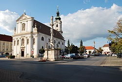
In 1921, when the western parts of Hungary were integrated to Austrian territory under the name of "Burgenland", Bruck remained divided between the provinces of Lower Austria and Burgenland. Bruck an der Leitha became the capital of the same-named district. Despite the important military base neighbouring Bruck, the town was not much affected by World War II. Today, Bruck has about 7300 inhabitants and still is the administrative center of the district. Important sights are the city walls from the 13th century, the Baroque church and the old castle, Schloss Prugg, of the Dukes of Harrach.

Today, the town is prospering in the energy department. It has nearby a large wind farm (possibly 60MW), which generates all the electricity for the town. In fact, the wind farm produces more energy than the town consumes, so the town profits off it through energy sales.

Subdivisions

People

Twin towns – sister cities

Bruck an der Leitha is twinned with Bruckmühl, Flag of Germany.svg  Germany, since 1974. [3]

See also

Related Research Articles

<span class="mw-page-title-main">Eisenstadt</span> Place in Burgenland, Austria

Eisenstadt is a city in Austria, the state capital of Burgenland. It had a recorded population on 29 April 2021 of 15,074.

<span class="mw-page-title-main">Leitha</span> River in Austria and Hungary

The Leitha is a river in Austria and Hungary, a right tributary of the Danube. It is 120.8 km (75.1 mi) long. Its basin area is 2,138 km2 (825 sq mi).

Rohrau is a village in the state of Lower Austria. The name comes from two German words: Rohr (reed) and Au. South of the village is a riparian forest and a swamp covered with reed.

<span class="mw-page-title-main">Großhöflein</span> Place in Burgenland, Austria

Großhöflein is a market town in eastern Austria, in the state of Burgenland. It is located near the state capital Eisenstadt.

<span class="mw-page-title-main">Schwechat</span> Municipality in Lower Austria, Austria

Schwechat is a city southeast of Vienna known for the Vienna International Airport and Schwechater beer. The city is home to the refineries of the Austrian national oil company OMV.

<span class="mw-page-title-main">Purbach am Neusiedlersee</span> Place in Burgenland, Austria

Purbach am Neusiedlersee, which is sometimes written as Purbach am Neusiedler See or Purbach am See, is a town in the Austrian state of Burgenland known for its viticulture. It lies in the Eisenstadt-Umgebung district.

<span class="mw-page-title-main">Kittsee</span> Place in Burgenland, Austria

Kittsee is an Austrian municipality in the District of Neusiedl am See, Burgenland.

<span class="mw-page-title-main">Kobersdorf</span> Place in Burgenland, Austria

Kobersdorf is an Austrian market town in Oberpullendorf, Burgenland.

<span class="mw-page-title-main">Leithaprodersdorf</span> Place in Burgenland, Austria

Leithaprodersdorf, also is an Austrian town located in the Eisenstadt-Umgebung district of the state of Burgenland. The town is located on Burgenland's northern border with Lower Austria, near the state capital of Eisenstadt.

<span class="mw-page-title-main">Harrach</span>

The House of Harrach is an old and influential Austro-German noble family, which was also part of Bohemian nobility. The Grafen (Counts) of Harrach were among the most prominent families in the Habsburg Empire. As one of few mediatized families, it belongs to high nobility.

<span class="mw-page-title-main">Neufeld an der Leitha</span> Place in Burgenland, Austria

Neufeld an der Leitha is a town in the district of Eisenstadt-Umgebung in the Austrian state of Burgenland. It lies on the river Leitha, which forms the border with Lower Austria.

<span class="mw-page-title-main">Wimpassing an der Leitha</span> Place in Burgenland, Austria

Wimpassing an der Leitha is a town in the district of Eisenstadt-Umgebung in the Austrian state of Burgenland.

<span class="mw-page-title-main">Zillingtal</span> Place in Burgenland, Austria

Zillingtal is a community of 925 inhabitants in the West of the district of Eisenstadt-Umgebung in Austria's federal state Burgenland.

<span class="mw-page-title-main">Bad Sauerbrunn</span> Place in Burgenland, Austria

Bad Sauerbrunn is the name of a mineral spa and the town in which it is located, in the district of Mattersburg in the Austrian state of Burgenland. The spa was used in ancient times by the Romans and was re-opened in 1847. The town, formerly called Savanyúkút, was part of German-speaking western Hungary until that territory became part of Austria in 1920. In 1921 Sauerbrunn, became the provisional capital of the newly formed federal state of Burgenland until 1925, when the seat of government moved to Eisenstadt.

<span class="mw-page-title-main">Draßburg</span> Place in Burgenland, Austria

Draßburg is a town in the district of Mattersburg in the Austrian state of Burgenland. There are numerous members of the Burgenland-Croatian minority in the village.

<span class="mw-page-title-main">Neudörfl</span> Place in Burgenland, Austria

Neudörfl is a town in the district of Mattersburg in the Austrian state of Burgenland.

<span class="mw-page-title-main">Schattendorf</span> Place in Burgenland, Austria

Schattendorf is a town in the district of Mattersburg in the Austrian state of Burgenland.

<span class="mw-page-title-main">Bruckneudorf</span> Place in Burgenland, Austria

Bruckneudorf is a small town in the district of Neusiedl am See in the federal state of Burgenland in Austria, neighbouring Bruck an der Leitha. Its name means bridge new village, whereas the Hungarian version means royal bridge, and the royal refers to King Francis I. Historically and geographically, Bruckneudorf represents the extension of the Austrian town of Bruck an der Leitha over the Austrian border into Hungary. This border, symbolised by the river Leitha, separated the Austrian Empire from the Kingdom of Hungary. Its main current national significance derives from the Bruckneudorf military exercise ground of the Austrian federal army. Currently it is also the site of Bruck an der Leitha railway station, an important railway station near the borders with Hungary and Slovakia, a stop for nearly all the international trains that pass through it.

<span class="mw-page-title-main">Potzneusiedl</span> Place in Burgenland, Austria

Potzneusiedl is the smallest village in the district of Neusiedl am See in Burgenland in Austria.

<span class="mw-page-title-main">Bruck an der Großglocknerstraße</span> Place in Salzburg, Austria

Bruck an der Großglocknerstraße is a municipality in Zell am See District, in the state of Salzburg in Austria.

References

  1. "Dauersiedlungsraum der Gemeinden Politischen Bezirke und Bundesländer - Gebietsstand 1.1.2018". Statistics Austria. Retrieved 10 March 2019.
  2. "Einwohnerzahl 1.1.2018 nach Gemeinden mit Status, Gebietsstand 1.1.2018". Statistics Austria. Retrieved 9 March 2019.
  3. "Partnerstadt". Bruck an der Leitha (in Austrian German). Retrieved 2022-12-17.