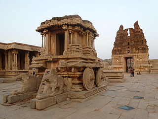
Koppala district, officially known as Koppala district is an administrative district in the state of Karnataka in India. In the past Koppal was referred to as 'Kopana Nagara'. Hampi, a World heritage center, covers some areas of Koppala District. It is situated approximately 38 km away. Anegundi, is also a famous travel destination.

Koppal is the district headquarters of Koppal district in the Indian state of Karnataka. Koppal is surrounded on three sides by hills. It was known as Kopana Nagara. The town has historical landmarks such as the Koppal Fort, Gavimath, and the Male Mallappa Temple. Historically, Koppal was known as Jaina Kashi, meaning the "Kashi" or most-sacred-place for Jains. It was so named because there were more than 700 Basadis, Jain meditation halls or Prarthana Mandirs. Koppal district was carved out of Raichur district, located in the northern part of Karnataka state, on 1 April 1998.
Alwandi is a village in the southern state of Karnataka, India. It is located in the Koppal taluk of Koppal district in Karnataka.
Basapattana is a village in the southern state of Karnataka, India. It is located in the Gangawati taluk of Koppal district in Karnataka.
Bevinhal is a village in the southern state of Karnataka, India. It is located in the Gangawati taluk of Koppal district in Karnataka.
Gundur is a village in the southern state of Karnataka, India. It is located in the Gangawati taluk of Koppal district in Karnataka.
Hanwal is a village in the southern state of Karnataka, India. It is located in the Koppal taluk of Koppal district in Karnataka.
Herur is a village in the southern state of Karnataka, India. It is located in the Gangawati taluk of Koppal district in Karnataka.
Hiremannapur is a village in the southern state of Karnataka, India. It is located in the Kushtagi taluk of Koppal district in Karnataka.
Hosekera is a village in the southern state of Karnataka, India. It is located in the Gangawati taluk of Koppal district in Karnataka.
Kawaloor is a village in the southern state of Karnataka, India. It is located in the Koppal taluk of Koppal district in Karnataka.
Kinnal also called Kinhal is a village in the southern state of Karnataka, India. It is located in the Koppal taluk of Koppal district in Karnataka. This village is famous for Kinnal Craft. Recently this Craft has been granted Geographical Indication and its GI tag number is 159.
Koppal (District) is a District in the southern state of Karnataka, India.
Marlanahalli is a village in the southern state of Karnataka, India. It is located in the Karatgi taluk of Koppal district in Karnataka.
Mustur is a village in the southern state of Karnataka, India. It is located in the Gangawati taluk of Koppal district in Karnataka.
Sriramanagar is a village in the southern state of Karnataka, India. It is located in the Gangawati taluk of Koppal district in Karnataka.
Tawargera is a Town Panchayat in the southern state of Karnataka, India. It is located in the Kushtagi taluk of Koppal district in Karnataka.
Yerdona is a village in the southern state of Karnataka, India. It is located in the Gangawati taluk of Koppal district in Karnataka.
Hulihaidar is a village in the Gangavathi taluk of Koppal district in the Indian state of Karnataka. Hulihaidar lies on Karnataka State Highway 29 connecting Kanakagiri and Tavaragera.
Irakalgada also spelled as Irkalgada is a village near Bewoor in the Koppal taluk of Koppal district in the Indian state of Karnataka. Irakalgada is located north to District Headquarters Koppal. Irakalgada lies on Karnataka State highway 36 connecting Koppal-Kushtagi. Irakalgada is 12 km from Koppal.

