
Chikmagalur, officially Chikkamagaluru is an administrative district in the Malnad subregion of Karnataka, India. Coffee was first cultivated in India in Chikmagalur. The hills of Chikmagalur are parts of the Western Ghauts and the source of Tunga and Bhadra rivers. Mullayanagiri, the highest peak in Karnataka is located in the district. The area is well known for the Sringeri Mutt that houses the Dakshina Peeta established by Adi Shankaracharya.

The Tungabhadra River is a river in India that starts and flows through the state of Karnataka during most of its course, before flowing along the border between Telangana, Andhra Pradesh and ultimately joining the Krishna River near Gundimalla village in Jogulamba Gadwal district of Telangana.
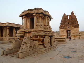
Koppala district, officially known as Koppala district is an administrative district in the state of Karnataka in India. In the past Koppal was referred to as 'Kopana Nagara'. Hampi, a World heritage center, covers some areas of Koppala District. It is situated approximately 38 km away. Anegundi, is also a famous travel destination.
Sindhanur is a city and taluk headquarter of Sindhanur taluk of Raichur District in Karnataka. The river Tungabhadra covers the irrigation area by left bank canal. Most of the land in the field is composed of cultivable black soil. Paddy is cultivated using the Tungabhadra River water. Sindhanur is also known as the Paddy Granary of Raichur. With the availability of Tungabhadra river water, paddy rice is grown twice a year. Sindhanur is the place where the majority of tractor sales take place in Asia. as agricultural activities take place year-round. Sona Masuri and Basmati rice are grown in Sindhanur.
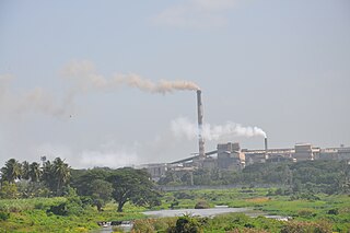
Bhadravati or Bhadravathi is an industrial city or Steel Town and taluk in the Shivamogga District of Karnataka state, India. It is situated at a distance of about 255 kilometres (158 mi) from the state capital Bengaluru and at about 20 kilometres (12 mi) from the district headquarters, Shivamogga. The town is spread over an area of 67.0536 square kilometres (25.8895 sq mi) and has a population of 151,102 as per the census held in 2011.

Shimoga district, officially known as Shivamogga district, is a district in the Karnataka state of India. A major part of Shimoga district lies in the Malnad region or the Sahyadri. Shimoga city is its administrative centre. Jog Falls view point is a major tourist attraction. As of 2011 Shimoga district has a population of 17,52,753. There are seven taluks: Soraba, Sagara, Hosanagar, Shimoga, Shikaripura, Thirthahalli, and Bhadravathi. Channagiri and Honnali were part of Shimoga district until 1997 when they became part of the newly formed Davanagere district.
Bangarapet is a town in Kolar district in the state of Karnataka, India. Bangarapet is the headquarters of the taluk of Bangarapet. Bangarapet was originally called Bowringpet, named after an officer working in the Kolar Gold Fields. This town came into existence as the connecting point of traffic between the gold fields and Bangalore.
Gangavati is a city, municipality and taluk in the Koppal district of the Indian state of Karnataka. It is one of the main commercial hubs in the Kalyana-Karnataka region. It is also the largest city, in terms of area and population, in the Koppal district.
Kampli is a town in the Bellary district, Kampli taluk, in the Indian state of Karnataka. It is a headquarters of Kampli Taluk. The town is situated about 15 km away from Hampi.
Sira is a city and taluk headquarters of Sira Taluk of Tumakuru district in the state of Karnataka, India. It lies on the AH 47, NH 48.
Gorebal is a village located 9 km from Sindhanur in the Raichur district of Karnataka state, India. Gorebal is well irrigated with Tunga Bhadra left bank canals 32 and 36.

Belavanaki is a village in southern state of Karnataka, India. It is located in Ron Taluka of Gadag district in Karnataka. It belongs to Belagavi Division.
Gandhinagar formerly known as Jalihal Camp, is one of the largest villages in Karnataka state in terms of area, population, property, agricultural production and revenue. It is the first government recognized revenue village in the Tunga Bhadra Delta Region. From 17 May 1997 onward, this village was renamed Gandhi Nagar from Jalihal Camp. is located on either sides of Tunga bhadra left Bank Canal,#36. In this village, there are many fertile, high-yielding paddy fields. Paddy is the main agricultural crop in the Tunga Bhadra Delta Region and the paddy varieties grown here include: Sonamasuri, Emergency, Ganga Kaveri, Nellore Sona, JJL, RS22.

The Bhadra Dam or Lakkavalli Dam, which has created the Bhadra Reservoir, is located on the Bhadra River a tributary of Tungabhadra River. Bhadra Dam is located in the border of Bhadravathi and Tarikere, in the western part of Karnataka in India. The benefits derived from the reservoir storage are irrigation with gross irrigation potential of 162,818 hectares, hydro power generation of 39.2 MW, drinking water supply and industrial use. The dam commissioned in 1965 is a composite earth cum masonry structure of 59.13 metres (194.0 ft) height with length of 1,708 metres (5,604 ft) at the crest level, which submerges a land area of 11,250.88 hectares.
Karatagi is a town and taluk headquarters located in Koppal District in Karnataka, India. It is one of the most important commercial centres in the district. The town is made up of multiple paddy fields, which are irrigated by the Tungabhadra Canal. Karatagi is known for its numerous rice mills, which can be found in the town and the surrounding areas.
Navali is a village in the Gangavathi taluk of Koppal district in Karnataka state, India.Navali is famous for Bhogapuresha temple and Bandi Huchamma Devi temple. Navali is 17 km from Karatagi. And near to koti linga temple pura Navali lies on Karatagi-Kanakagiri road and Kalmungi -Gangavati road Which is known as RTP for paddy production of rice
Bahaddur Bandi, also spelled Bahaddurbandi is a village in the Koppal taluk of Koppal district in the Indian state of Karnataka. Bahaddur Bandi is located south to District Headquarters Koppal and is 4 km from Koppal city.
Hemagudda near Kammatadurga is a village in the Gangavathi taluk of Koppal district in the Indian state of Karnataka. Hemagudda is located northeast to District Headquarters Koppal. Hemagudda is 12 kilometres (7.5 mi) from Gangavathi and 20 kilometres (12.4 mi) from.
Hiresindhogi also spelled as Hire Sindhogi is a village in the Koppal taluk of Koppal district in the Indian state of Karnataka. Hiresindhogi is located South to District Headquarters Koppal and is 12 km from Koppal city.

Sanapur is a village in Gangavathi taluk, Koppal district in Karnataka, India. It has a population of 1628 according to 2011 census. A lake in the village fed by Tungabhadra Dam canal is a tourist attraction. It is 3 km (1.9 mi) away from Virupapur Gaddi and 4 km (2.5 mi) away from Hampi.
