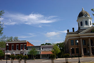
Monticello is the largest city in and the county seat of Jasper County, Georgia, United States. The city includes historic buildings such as the Jasper County Courthouse, Monticello High School and the Monticello Historic District. The population was 2,541 in 2020. It is 56 miles (90 km) southeast of Atlanta.

York is a city in and county seat of York County, South Carolina, United States. The population was approximately 6,985 at the 2000 census and up to 7,736 at the 2010 census. York is located approximately 27 miles (43 km) southwest of Charlotte, North Carolina and 13 miles (21 km) west of Rock Hill, South Carolina.
Orange is a town and the county seat of Orange County, Virginia, United States. The population was 4,880 at the 2020 census, representing a 3.4% increase since the 2010 census. Orange is 28 miles (45 km) northeast of Charlottesville, 88 miles (142 km) southwest of Washington, D.C., and 4 miles (6 km) east of Founding Father and fourth U.S. president James Madison's plantation of Montpelier.

Courtland is an incorporated town in Southampton County, Virginia, United States. It is the county seat of Southampton County.

Abingdon is a town in Washington County, Virginia, United States, 133 miles (214 km) southwest of Roanoke. The population was 8,376 at the 2020 census. It is the county seat of Washington County. The town encompasses several historically significant sites and features a fine arts and crafts scene centered on the galleries and museums along Main Street.
Wise is a town in Wise County, Virginia. The population was 3,286 at the 2010 census. It is the county seat of Wise County. It was originally incorporated as the town of Gladeville in 1874. The town's name was changed to Wise in 1924, after Henry A. Wise, the last Virginia governor before the American Civil War and the first governor to hail from the Eastern Shore of Virginia.

Shinnston is a city and former coal town in Harrison County, West Virginia, United States, along the West Fork River. In 1778, Levi Shinn constructed his log home along what is now Route 19; today it is the oldest standing structure in north-central West Virginia. As of the 2020 census, Shinnston had a population of 2,332.

Lancaster is a village in Erie County, New York, United States. As of the 2010 census, the village population was 10,352. It is part of the Buffalo-Niagara Falls metropolitan area.

Old Salem is a historic district of Winston-Salem, North Carolina, United States, which was originally settled by the Moravian community in 1766. It features a living-history museum which interprets the restored Moravian community. The non-profit organization began its work in 1950, although some private residents had restored buildings earlier. As the Old Salem Historic District, it was declared a National Historic Landmark (NHL) in 1966, and expanded fifty years later. The district showcases the culture of the Moravian settlement in the Province of North Carolina during the colonial 18th century and post-statehood 19th century via its communal buildings, churches, houses and shops.

The Garden District is a neighborhood of the city of New Orleans, Louisiana, United States. A subdistrict of the Central City/Garden District Area, its boundaries as defined by the New Orleans City Planning Commission are: St. Charles Avenue to the north, 1st Street to the east, Magazine Street to the south, and Toledano Street to the west. The National Historic Landmark district extends a little farther.

Buildings, sites, districts, and objects in Virginia listed on the National Register of Historic Places:

The Corydon Historic District is a national historic district located in Corydon, Indiana, United States. The town of Corydon is also known as Indiana's First State Capital and as Historic Corydon. The district was added to the National Register of Historic Places in 1973, but the listing was amended in 1988 to expand the district's geographical boundaries and include additional sites. The district includes numerous historical structures, most notably the Old Capitol, the Old Treasury Building, Governor Hendricks' Headquarters, the Constitution Elm Memorial, the Posey House, the Kintner-McGrain House, and The Kintner House Inn, as well as other residential and commercial sites.

Lovingston is a census-designated place (CDP) in and the county seat of Nelson County, Virginia, United States. The population, as of the 2010 Census, was 520. Its ZIP Code is 22949. It was among the communities severely affected by flash flooding from Hurricane Camille in 1969.

The boundary markers of the original District of Columbia are the 40 milestones that marked the four lines forming the boundaries between the states of Maryland and Virginia and the square of 100 square miles (259 km2) of federal territory that became the District of Columbia in 1801. Working under the supervision of three commissioners that President George Washington had appointed in 1790 in accordance with the federal Residence Act, a surveying team led by Major Andrew Ellicott placed these markers in 1791 and 1792. Among Ellicott's assistants were his brothers Joseph and Benjamin Ellicott, Isaac Roberdeau, George Fenwick, Isaac Briggs and an African American astronomer, Benjamin Banneker.

The Second Union School is a historic Rosenwald school building for African-American children located near Fife, in western Goochland County, Virginia. It was built in 1918, as a two-teacher school, near Second Union Baptist Church, which had been founded in 1865 as an independent black congregation.

Eagar Townsite Historic District is a section of the town of Eagar, Arizona which has been designated a National Historic Place. Sitting on roughly 54 acres, the site contains 37 structures, 21 of which have historical significance. The period of significance is from 1886, the year the townsite was founded, through 1942, which represents the significant period of development of the town. The site was added to the Register on July 23, 1993.
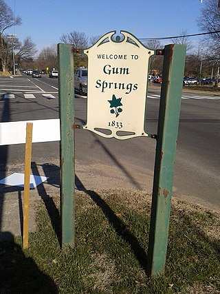
Gum Springs is a community in Fairfax County in Hybla Valley along Route 1. The African American community, the oldest in the county, was established in 1833 by West Ford, a freedman who had been manumitted by Hannah Bushrod Washington, in 1805. A historical marker was erected by the Virginia Department of Historic Resources in 1991.


