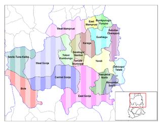
The Districts of Ghana are second-level administrative subdivisions of Ghana, below the level of region. There are 261 local metropolitan, municipal and district assemblies.
Bunkpurugu is a small town and is the capital of Bunkpurugu Nyankpanduri district, a district in the North East Region of Ghana adjacent to the border with Togo. It was formerly the capital of the Bunkpurugu-Yunyoo District.
The Upper East Region is located in north Ghana and is the third smallest of the 16 administrative regions in Ghana. It occupies a total land surface of 8,842 square kilometers or 2.7 per cent of the total land area of Ghana. The Upper East regional capital is Bolgatanga, sometimes referred to as Bolga. Other major towns in the region include Navrongo, Paga, Bawku and Zebilla.

East Mamprusi Municipal Assembly is one of the six districts in North East Region, Ghana. Originally created as an ordinary district assembly in 1988 when it was known as East Mamprusi District, which was created from the former Mamprusi District Council, until the eastern part of the district was split off by a decree of president John Agyekum Kufuor on 19 August 2004 to create Bunkpurugu-Yunyoo District; thus the remaining part has been retained as East Mamprusi District. However on 15 March 2018, it was elevated to municipal district assembly status to become East Mamprusi Municipal District. The municipality is located in the eastern part of North East Region and has Gambaga as its capital town.
West Mamprusi Municipal Assembly is one of the six districts in North East Region, Ghana. Originally created as an ordinary district assembly in 1988 when it was known as West Mamprusi District, which was created from the former Mamprusi District Council, until the western part of the district was split off on 28 June 2012 to create Mamprugu-Moagduri District; thus the remaining part has been retained as West Mamprusi District. However, on 15 March 2018, it was elevated to municipal district assembly status to become West Mamprusi Municipal District. The municipality is located in the western part of North East Region and has Walewale as its capital town. Other settlements within the municipal assembly include Wulugu.

Gushegu Municipal District is one of the sixteen districts in Northern Region, Ghana. Originally it was formerly part of the then-larger Gushegu-Karaga District in 1988, which was created from the former East Dagomba District Council, until the western part of the district was split off to create Karaga District on 27 August 2004; thus the remaining part has been renamed as Gushegu District, which it was later elevated to municipal district assembly status on that same year to become Gushegu Municipal District. The municipality is located in the northeast part of Northern Region and has Gushegu as its capital town.
Karaga District is one of the sixteen districts in Northern Region, Ghana. Originally it was formerly part of the then-larger Gushegu-Karaga District in 1988, which was created from the former East Dagomba District Council, until the western part of the district was split off to create Karaga District on 27 August 2004; thus the remaining part has been renamed as Gushegu District, which it was later elevated to municipal district assembly status on that same year to become Gushegu Municipal District. The district assembly is located in the northeast part of Northern Region and has Karaga as its capital town.
Bunkpurugu-Yunyoo is one of the constituencies represented in the Parliament of Ghana. It elects one Member of Parliament (MP) by the first past the post system of election. Bunkpurugu-Yunyoo is located in the Bunkpurugu-Yunyoo district of the Northern Region of Ghana.

Awutu Senya District is a former district that was located in Central Region, Ghana. Originally it was formerly part of the then-larger Awutu/Effutu/Senya District on 29 February 2008. However on 28 June 2012, it was split out into two new districts: Awutu Senya West District and Awutu Senya East District. The district assembly was located in the southeast part of Central Region and had Awutu Breku as its capital town.
Walewale is one of the constituencies represented in the Parliament of Ghana. It elects one Member of Parliament (MP) by the [first past the post] / Simple Majority] system of election. Walewale is located in the West Mamprusi Municipal of the North East Region of Ghana. It is the Municipal capital of West Mamprusi Municipal Assembly. The constituency was formerly called the West Mamprusi Constituency.
Nalerigu is the largest town in the East Mamprusi Municipal Assembly in the North East Region of Ghana as well as the traditional capital of the Mamprusi people, the seat of the Paramount Chief, the NaYiri. Nalerigu is also the capital of the North East Region of Ghana.
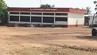
Gambaga is the capital of the East Mamprusi Municipal Assembly in the North East Region of Ghana. Once a residence of Mamprusi-kings it is still the capital of East Mamprusi Municipal Assembly, a municipality in the North East Region of Ghana. It is home to several ancient Mossi chiefs' gravsites.

Nakpanduri is a village in Bunkpurugu-Nakpanduri District, a district in the North East Region of north Ghana adjacent to the border with Togo.
Mamprugu-Moagduri District is one of the six districts in North East Region, Ghana. Originally it was formerly part of a then-larger West Mamprusi District in 1988, which was created from the former Mamprusi District Council, until the western part of the district was split off on 28 June 2012 to create Mamprugu-Moagduri District; thus the remaining part was still has been retained West Mamprusi District. The district assembly is located in the western part of North East Region and has Yagaba as its capital town.
Bunkpurugu is one of the constituencies represented in the Parliament of Ghana. It elects one Member of Parliament (MP) by the first past the post system of election. Bunkpurugu is located in the Bunkpurugu-Yunyoo District of the North East Region of Ghana.
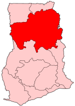
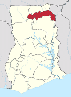
The North East Region is one of the sixteen regions of Ghana. It is located in the north of the country and was created in December 2018 after a referendum was voted upon to break it off of the Northern region. The region's capital is Nalerigu.
Mamprusi District is a former district council that was located in Northern Region,, Ghana. Originally created as an ordinary district assembly in 1975. However on 1988, it was split off into two new district assemblies: East Mamprusi District and West Mamprusi District. The district assembly was located in the northeast part of Northern Region and had Gambaga as its capital town.
Bunkpurugu-Nyankpanduri District is one of the six districts in North East Region, Ghana. Originally it was formerly part of the then-larger Bunkpurugu-Yunyoo District on 19 August 2004, which was created from the former Mamprusi District Council, until the southern part of the district was split off to create Yunyoo-Nasuan District on 15 March 2018; thus the remaining part has been renamed as Bunkpurugu-Nyankpanduri District. The district assembly was located in the northeast part of Northern Region and had Bunkpurugu as its capital town.
Yunyoo-Nasual District is one of the six districts in North East Region, Ghana. Originally it was formerly part of the then-larger Bunkpurugu-Yunyoo District on 19 August 2004, which was created from the former Mamprusi District Council, until the southern part of the district was split off to create Yunyoo-Nasuan District on 15 March 2018; thus the remaining part has been renamed as Bunkpurugu-Nyankpanduri District. The district assembly was located in the northeast part of Northern Region and had Yunyoo as its capital town.
Yunyoo is the capital of the Yunyoo-Nasuan District in the North East Region of Ghana. The district was one of the new ones inaugurated on 15 March 2018 in Ghana.


