
Ivory Coast is a sub-Saharan nation in southern West Africa located at 8° N, 5° W. The country is approximately square in shape.

Bolgatanga, colloquially known as Bolga, is a town and the capital of the Bolgatanga Municipal and the Upper East Region of Ghana, adjacent to the border with Burkina Faso. Bolgatanga is 161 km (100 mi) to the north of Tamale. The town lies in the Red Volta Valley, with the White Volta and the cliffs of the Gambaga escarpment to the south of the town forming the southern boundary of the Upper East Region. As of 2012, the town has a population of about 66,685 people. Some ethnic groups who lived in large qualities in Bolgatanga are Northerners, Akan, Ewe, and Ga-Adangbe. The current mayor of the town is Rex Asanga.
The Districts of Ghana are second-level administrative subdivisions of Ghana, below the level of region. There are currently 261 local metropolitan, municipal and district assemblies.

The Upper West Region of Ghana is located in the north-western corner of Ghana and is bordered by Upper East Region to the east, Northern Region to the south, and Burkina Faso to the west and north. The Upper West regional capital and largest settlement is Wa. The Upper West was created by the then Head of State, Jerry Rawlings in 1983 under the Provisional National Defence Council (PNDC) military regime. The area was carved out of the former Upper Region, which is now the Upper East Region. For about thirty-five years, it remained the youngest region of Ghana until 2018 when six more regions were created by the Nana Addo Dankwa Akufo-Addo government; hence increasing the total number of administrative regions in the country to sixteen.
Paga is a town in Upper East Region of Ghana, lying north of Bolgatanga. Paga is the capital of Kassena Nankana West District, a district in the Upper East Region in the northern part of Ghana. The town is located on the border of Burkina Faso and is 166 km south of Ouagadougou via the N5 highway, the main road linking Ghana and Burkina Faso. The majority of the people of Paga are of the Kassena tribe.
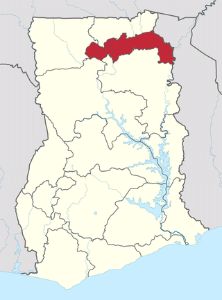
The Upper East Region is located in northern part of Ghana and it is the third smallest of the 16 administrative regions in Ghana. It occupies a total land surface of 8,842 square kilometers or 2.7% of the total land area of Ghana. The regional capital is Bolgatanga, which is sometimes referred to as Bolga. Other major towns in the region include Navrongo, Paga, Sandema, Bawku, and Zebilla, Tempane, Pusiga, Garu, Pwalugu, Widana

Lawra Municipal is one of the eleven districts in the Upper West Region of Ghana. Originally, it was formerly part of the then-larger Lawra District in 1988, until the northern part of the district was later split off to create Nandom District on June 28, 2012; thus, the remaining part has remained as Lawra District, which was later elevated to municipal assembly status on March 15, 2018 to become Lawra Municipal Assembly. The municipality is located in the northwest part of the Upper West Region and has Lawra as its capital town.

West Mamprusi Municipal Assembly is one of the six districts in North East Region, Ghana. Originally created as an ordinary district assembly in 1988 when it was known as West Mamprusi District, which was created from the former Mamprusi District Council, until the western part of the district was split off on 28 June 2012 to create Mamprugu-Moagduri District; thus the remaining part has been retained as West Mamprusi District. However, on 15 March 2018, it was elevated to municipal district assembly status to become West Mamprusi Municipal District. The municipality is located in the western part of North East Region and has Walewale as its capital town. Other settlements within the municipal assembly include Wulugu.
Wa West District is one of the eleven districts in Upper West Region, Ghana. Originally it was formerly part of the then-larger Wa District in 1988; until two parts of the district were later split off to create Wa East District and Wa West District respectively in July 2004; thus the remaining part was elevated to municipal district assembly status on the same year to become Wa Municipal District. The district assembly is located in the southern part of Upper West Region and has Wechiau as its capital town.
Mamprusis are an ethnic group in northern Ghana and Togo. Estimates are that there are about 200,000 Mamprusis living in the Northern Regions of Ghana as of 2013. They speak Mampruli, one of the Gur languages. In Ghana, the Mamprusis live mainly in Nalerigu, Gambaga, Walewale, and their surrounding towns and villages in the North East Region. Their origin is in the Upper East Region, principally, Bawku, and they also inhabit parts of the Upper West Region, too.
Wegbe Kpalime is a village located in the South Dayi District of the Volta Region of Ghana.
Lambussie Karni District is one of the eleven districts in Upper West Region, Ghana. Originally it was formerly part of the then-larger Jirapa/Lambussie District in 1988; until the northern part of the district was later split off to create Lambussie-Karni District on 29 February 2008; thus the remaining part has been renamed as Jirapa District. The district assembly is located in the northwest part of Upper West Region and has Lambussie as its capital town.
Yagaba-Kubori is one of the constituencies represented in the Parliament of Ghana. It elects one Member of Parliament (MP) by the first past the post system of election. It is located in the North East Region of Ghana. The current member of Parliament for the constituency is Abdul-Rauf Tanko Ibrahim. He was elected on the ticket of the National Democratic Congress (NDC) and won a majority of 1,330 votes more than candidate closest in the race, to win the constituency election to become the MP. He had represented the constituency in the 4th Republican parliament on the ticket of the National Democratic Congress.

Walewale is a town and the capital of Mamprusi West Municipal in the North East Region of Ghana. The West Mamprusi Municipal is one of the 261 Metropolitan, Municipal, and District Assemblies (MMDAs) in Ghana, and forms part of the 6 MMDAs in the North East Region. The West Mamprusi Municipality is one of 45 new districts created in 1988 under the Government of Ghana’s decentralization and was later replaced with LI 2061 in 2012. With its administrative capital as Walewale.
Nandom is the capital town of the Nandom Municipal of the Upper West Region of Ghana.
Mamprugu-Moagduri District is one of the six districts in North East Region, Ghana. Originally it was formerly part of a then-larger West Mamprusi District in 1988, which was created from the former Mamprusi District Council, until the western part of the district was split off on 28 June 2012 to create Mamprugu-Moagduri District; thus the remaining part was still has been retained West Mamprusi District. The district assembly is located in the western part of North East Region and has Yagaba as its capital town.
The North East Region is one of the sixteen regions of Ghana. It is located in the north of the country and was created in December 2018 after a referendum was voted upon to break it off of the Northern region. The region's capital is Nalerigu.
Issa is the capital of the Daffiama Bussie Issa district in the Upper West Region of Ghana. It became the capital after the district was established in 2012.
Kpalbe or Palbe is a town in the Savannah Region of Ghana. It is the capital of the North East Gonja District.
Adansi Asokwa is the capital of the Adansi Asokwa District in the Ashanti Region of Ghana. The district itself was created out of the Adansi North District by Legislative Instrument in 2018. It is located in the southern half of the region on the N8 highway running from Kumasi, capital of the region to Yamoransa near Cape Coast, capital of the Central Region. It is also the main town in the Asokwa Area Council, one of four in the district.


