Buren, Friesland

Last updated
Buren
Village
Buren Ameland Bureweg 2019.jpg
Buren
LocatieBurenAmeland.png
Location in Ameland municipality
2010-NL-P02-Fryslan-positiekaart-gemnamen.jpg
Red pog.svg
Buren
Location in the province of Friesland
Netherlands location map.svg
Red pog.svg
Buren
Buren (Netherlands)
Coordinates: Coordinates: 53°26′50″N5°47′56″E / 53.44722°N 5.79889°E / 53.44722; 5.79889
Country Flag of the Netherlands.svg Netherlands
Province Frisian flag.svg Friesland
Municipality Flag of Ameland.svg Ameland
Area
[1]
  Total21.43 km2 (8.27 sq mi)
Elevation
[2]
3.7 m (12.1 ft)
Population
 (2021) [1]
  Total740
  Density35/km2 (89/sq mi)
Time zone UTC+1 (CET)
  Summer (DST) UTC+2 (CEST)
Postal code
9164
Dialing code 0519

Buren is the easternmost village on the island of Ameland, one of the West Frisian Islands and part of the Netherlands. Buren had, as of January 2017, a population of 715. [3]

Contents

History

The village was first mentioned in the late 11th century as Buren, and means neighbourhood. [4] Buren developed in the Late Middle Ages around a village square. [5] It was originally a Catholic village. Buren was home to 147 people in 1840. [6]

Rixt van het Oerd

Buren is also home to the infamous legend of the witch Rixt van het Oerd (e.g. Rixt of Oerd). This old lady would tie a lantern on a cow who she would chase into the dunes. She would hope for a ship to mistake the cow for a lighthouse, thinking it was a safe haven. Instead the ship would run aground on the sand bars along the coastline, leaving its cargo for her to pick up from the beach. One day in a heavy storm, she practiced her reckless way of making extra money and encountered the dead body of a drowned sailor. As she came closer she realized that it was her own son, Sjoerd. After realizing what she has done, every time there is now a storm raging over Ameland, she howls out her son's name in the wind.

In remembrance of the legend of Rixt van het Oerd, there is a small statue in the center of Buren.

500 years ago the population consisted of pirates and bandits, today the residents live from the tourist industry (school classes from Germany visit Ameland and stay at Buren).

Related Research Articles

Ameland Municipality in Friesland, Netherlands

Ameland is a municipality and one of the West Frisian Islands off the north coast of the Netherlands. It consists mostly of sand dunes. It is the third major island of the West Frisians. It neighbours islands Terschelling to the west and Schiermonnikoog to the east. This includes the small Engelsmanplaat and Rif sandbanks to the east.

Schiermonnikoog Municipality in Friesland, Netherlands

Schiermonnikoog is an island, a municipality and national park in the Northern Netherlands. Schiermonnikoog is one of the West Frisian Islands, and is part of the province of Friesland. It is situated between the islands of Ameland and Rottumerplaat.

Hollum Village in Friesland, Netherlands

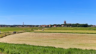
Hollum is the largest village on Ameland, Netherlands, one of the West Frisian Islands. It is situated on the westernmost part of the island and had, as of January 2017, a population of 1,165.

Uithuizermeeden Village in Groningen, Netherlands

Uithuizermeeden is a village in the Netherlands, with a population of about 3,200 people. It is part of the municipality of Het Hogeland, close to the Wadden Sea.

Usquert Village in Groningen, Netherlands

Usquert is a village in the Dutch province of Groningen. It is located in the municipality of Het Hogeland. It had a population of around 1,415 in January 2017.

Nes, Ameland Village in Friesland, Netherlands

Nes is the second largest village on the island of Ameland, one of the West Frisian Islands in the northern Netherlands.

Zijdewind Village in North Holland, Netherlands

Zijdewind is a village in the Dutch province of North Holland. It is a part of the municipality of Hollands Kroon, and lies about 8 km north of Heerhugowaard.

Maurik Town in Gelderland, Netherlands

Maurik is a town in the Dutch province of Gelderland. It is a part of the municipality of Buren, and lies about 8 km north of Tiel.

Buurmalsen Village in Gelderland, Netherlands

Buurmalsen is a village in the Dutch province of Gelderland. It is a part of the municipality of West Betuwe, and lies about 9 km west of Tiel. Part of the village is located in Buren.

Kantens Village in Groningen, Netherlands

Kantens is a village in the Dutch province of Groningen. It is located in the municipality of Het Hogeland, about 16 km north of the city of Groningen. It had a population of around 965 including the surrounding area in January 2017.

Ballum Village in Friesland, Netherlands

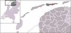
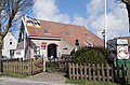
Ballum is a village on the western half of the island of Ameland and the smallest of the total of four villages on the island, one of the West Frisian Islands and part of the Netherlands.

Holwerd Village in Friesland, Netherlands

Holwerd is a village in Noardeast-Fryslân municipality in the northern Netherlands, in the province of Friesland. It had a population of around 1,607 in January 2017. Before 2019, the village was part of the Dongeradeel municipality.

Nij Altoenae Village in Friesland, Netherlands

Nij Altoenae is a village in Waadhoeke municipality in the province of Friesland, the Netherlands. It had a population of around 300 in January 2017.

Oosterzee Village in Friesland, Netherlands

Oosterzee is a village in De Fryske Marren municipality in the province of Friesland, the Netherlands. It had a population of around 915 including surrounding area in 2017.

Olterterp Village in Friesland, Netherlands

Olterterp is a village in the municipality of Opsterland in the east of Friesland, the Netherlands. It had a population of around 75 in January 2017.

Tjerkwerd Village in Friesland, Netherlands

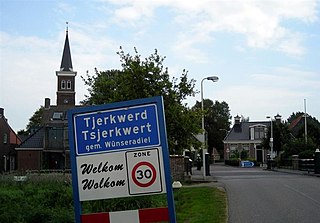
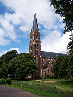
Tjerkwerd is a village in Súdwest-Fryslân municipality in the province Friesland of the Netherlands. It had a population of 455 in January 2017.

Burgwerd Village in Friesland, Netherlands

Burgwerd is a small village in Súdwest-Fryslân in the province of Friesland, the Netherlands. It had a population of around 315 in January 2017. It is located near the Boalserter Trekfeart.

Blauwhuis Village in Friesland, Netherlands

Blauwhuis is a village in Súdwest-Fryslân municipality in the province of Friesland, the Netherlands. It had a population of around 585 in January 2017.

Koufurderrige Village in Friesland, Netherlands

Koufurderrige is a village in Súdwest-Fryslân municipality in the province of Friesland, the Netherlands. It had a population of around 115 in January 2017.

Oosthem Village in Friesland, Netherlands

Oosthem is a village in Súdwest-Fryslân in the province of Friesland, the Netherlands. It had a population of around 420 in January 2017.

References

  1. 1 2 "Kerncijfers wijken en buurten 2021". Central Bureau of Statistics. Retrieved 26 April 2022.
  2. "Postcodetool for 9164KA". Actueel Hoogtebestand Nederland (in Dutch). Het Waterschapshuis. Retrieved 26 April 2022.
  3. Kerncijfers wijken en buurten 2017 - CBS (in Dutch)
  4. "Buren - (geografische naam)". Etymologiebank (in Dutch). Retrieved 26 April 2022.
  5. Ronald Stenvert & Sabine Broekhoven (2000). "Nes" (in Dutch). Zwolle: Waanders. ISBN   90 400 9476 4 . Retrieved 31 March 2022.
  6. "Buren (Ameland)". Plaatsengids (in Dutch). Retrieved 26 April 2022.

Commons-logo.svg Media related to Buren, Ameland at Wikimedia Commons