
Victoria Island is a large island in the Canadian Arctic Archipelago that straddles the boundary between Nunavut and the Northwest Territories of Canada. It is the eighth largest island in the world, and at 217,291 km2 (83,897 sq mi) in area, it is Canada's second largest island. It is nearly double the size of Newfoundland (111,390 km2 [43,008 sq mi]), and is slightly larger than the island of Great Britain (209,331 km2 [80,823 sq mi]) but smaller than Honshu (225,800 km2 [87,182 sq mi]). It contains the world's largest island within an island within an island. The western third of the island belongs to the Inuvik Region in the Northwest Territories; the remainder is part of Nunavut's Kitikmeot Region.

The Arctic Archipelago, also known as the Canadian Arctic Archipelago, is a group of islands north of the Canadian mainland.

Byam Martin Island (BEI-uhm) is one of the Canadian arctic islands located on the northern side of the Viscount Melville Sound in the territory of Nunavut. It is separated from the eastern coast of Melville Island, 27 km (17 mi) to the west, by the Byam Martin Channel; and from Bathurst Island, 35 km (22 mi) to the northeast, by the Austin Channel.

The Byam Martin Mountains are a rugged mountain range extending east to west across Bylot Island, Nunavut, Canada. It is one of the most northern ranges in the world and is an extension of the Baffin Mountains which in turn form part of the Arctic Cordillera mountain system. The highest mountain in the range is Angilaaq Mountain, 1,951 m (6,401 ft), located near the island's center. Sharp peaks and ridges, divided by deep glacier-filled valleys are typical features in the range and has been extensively modified by glacial erosion. The Byam Martin Mountains have not been conducive to habitation. While there are no permanent settlements in the Byam Martin Mountains, Inuit from Pond Inlet and elsewhere regularly travel to the range.

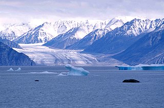
Sermilik Glacier is a glacier located in the southern Byam Martin Mountains of Bylot Island, Nunavut, Canada. It lies in Sirmilik National Park.
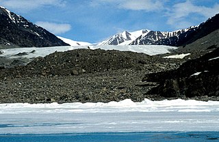
Kaparoqtalik Glacier is a glacier located in the southern coast of the Byam Martin Mountains on Bylot Island, Nunavut, Canada. It lies in Sirmilik National Park.
Narsarsuk Glacier is a glacier in the southeastern Byam Martin Mountains of Bylot Island, Nunavut, Canada.
M'Clintock Channel is located in the territory of Nunavut, Canada. The channel, an arm of the Arctic Ocean, divides Victoria Island from Prince of Wales Island. This channel is named after Sir Francis Leopold McClintock, an Irish explorer in the British Royal Navy, famous for his Canadian Arctic explorations. The channel is 170 miles (274 km) long, and between 65 to 130 mi wide, making it one of the largest channels in the Canadian Arctic Archipelago.
Goldsmith Channel is a waterway in the Canadian territory of Nunavut connecting Parry Channel and M'Clintock Channel. Broadest in the northwest, the island-filled channel narrows as it progresses to the southeast where it separates northeastern Victoria Island's Storkerson Peninsula from western Stefansson Island by a few hundred meters of shallow water. This is an uninhabited, extremely remote area. Elvira Island is located at the head of the channel.
The Wellington Channel is a natural waterway through the central Canadian Arctic Archipelago in Qikiqtaaluk Region, Nunavut. It runs north/south, separating Cornwallis Island and Devon Island. In 1845 Sir John Franklin wintered at Beechey Island at its southeast end. In 1850 2 ships were caught in the ice. In the spring of 1851 it was explored by William Penny who went by sledge to the northwest tip of Devon Island. Edward Belcher explored it in 1852.
Weatherall Bay is an Arctic waterway in Qikiqtaaluk Region, Nunavut, Canada. It is located in the Byam Martin Channel, northeast of Melville Island. Domett Point is at its mouth.
The Byam Martin Channel is a natural waterway through the central Canadian Arctic Archipelago Qikiqtaaluk Region, Nunavut, Canada. It separates Mackenzie King Island and Melville Island from Lougheed Island, Cameron Island, Île Vanier, Massey Island and Île Marc. To the south it opens into Byam Channel and Austin Channel.

The Austin Channel is a natural waterway through the central Canadian Arctic Archipelago in the Qikiqtaaluk Region, Nunavut. It separates Byam Martin Island from Melville Island and the Alexander and Bathurst Islands. To the north it opens to the Byam Martin Channel, to the south-west to the Byam Channel, and to the south-east to the Viscount Melville Sound.
The Findlay Group is a group of islands in the Canadian Arctic Archipelago in Qikiqtaaluk Region, Nunavut. This Arctic Ocean group consists of Lougheed Island, Stupart Island, Edmund Walker Island, Grosvenor Island and Patterson Island.
Arnott Strait is a waterway in the Qikiqtaaluk Region of Nunavut, Canada. It separates Cameron Island from Île Vanier. To the west, the strait opens into the Byam Martin Channel.
Pearse Strait is a waterway in the Qikiqtaaluk Region of Nunavut, Canada. It separates Île Vanier from Massey Island. To the west, the strait opens into the Byam Martin Channel, and to the east it opens into the Erskine Inlet.
Boyer Strait is a waterway in the Qikiqtaaluk Region of Nunavut, Canada. It separates Massey Island from Alexander Island. Île Marc is located at the western end of the strait, beyond which it opens into the Byam Martin Channel. To the east it opens into the Erskine Inlet.
Pell Inlet is a waterway in the Qikiqtaaluk Region of Nunavut, Canada. It separates Alexander Island from Bathurst Island. To the west, the strait opens into the Byam Martin Channel, and to the east it opens into the Erskine Inlet.
The Murray Inlet is a large inlet on the south-west side of Melville Island, Northwest Territories, Canada. It joins the Liddon Gulf and M'Clure Strait to the south-west.

