
Belcher Channel is a waterway in Norwegian Bay in the Canadian territory of Nunavut. It separates Cornwall Island from Devon Island. [1] Table Island and Ekins Island lie within the channel.
Belcher Channel is a waterway in Norwegian Bay in the Canadian territory of Nunavut. It separates Cornwall Island from Devon Island. [1] Table Island and Ekins Island lie within the channel.

The Arctic Archipelago, also known as the Canadian Arctic Archipelago, is an archipelago lying to the north of the Canadian continental mainland, excluding Greenland.
The Belcher Islands are an archipelago in the southeast part of Hudson Bay near the centre of the Nastapoka arc. The Belcher Islands are spread out over almost 3,000 km2 (1,200 sq mi). Administratively, they belong to the Qikiqtaaluk Region of the territory of Nunavut, Canada. The hamlet of Sanikiluaq is on the north coast of Flaherty Island and is the southernmost in Nunavut. Along with Flaherty Island, the other large islands are Kugong Island, Tukarak Island, and Innetalling Island. Other main islands in the 1,500–island archipelago are Moore Island, Wiegand Island, Split Island, Snape Island and Mavor Island, while island groups include the Sleeper Islands, King George Islands, and Bakers Dozen Islands.
Sanikiluaq is a municipality and Inuit community located on the north coast of Flaherty Island in Hudson Bay, on the Belcher Islands. Despite being geographically much closer to the shores of Ontario and Quebec, the community and the Belcher Islands lie within the Qikiqtaaluk Region of Nunavut, Canada.

Amund Ringnes Island is one of the Sverdrup Islands in the Qikiqtaaluk Region, Nunavut, Canada. It is located in the Arctic Ocean, between 78 and 79 degrees of latitude. It lies east of Ellef Ringnes Island, west of Axel Heiberg Island. Hassel Sound separates Amund Ringnes Island from Ellef Ringnes Island. Hendriksen Strait is to the south, as is Cornwall Island. Norwegian Bay is to the east, as is Haig-Thomas Island. To the north lies Peary Channel.

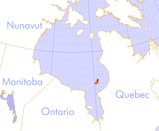
Cornwall Island is a small island in the high arctic region of the Canadian territory of Nunavut. It is near the geometric centre of the Queen Elizabeth Islands. To the north, it is separated from Amund Ringnes Island by Hendriksen Strait. To the south, it is separated from Devon Island by Belcher Channel. It is the largest of six islands in the Norwegian Bay, west of Ellesmere Island.
Keremeos Columns Park is a provincial park in British Columbia, Canada. Established in 1931, the park covers a total area of 20 hectares.
The Canadian territory of Nunavut covers about 1.9 million square kilometres of land and water including part of the mainland, most of the Arctic islands, and all of the islands in Hudson Bay, James Bay, and Ungava Bay which belonged to the Northwest Territories. This makes it the fifth largest country subdivision in the world. If Nunavut were a country, it would rank 13th in area, after the Democratic Republic of the Congo. Nunavut has land borders with Manitoba, the Northwest Territories on several islands as well as the mainland, and a tiny land border with Newfoundland and Labrador on Killiniq Island.
The Ottawa Islands are a group of currently uninhabited islands situated in the eastern edge of Canada's Hudson Bay. The group comprises 24 small islands, located at approximately 60N 80W. The main islands include Booth Island, Bronson Island, Eddy Island, Gilmour Island, J. Gordon Island, Pattee Island, and Perley Island. The highest point is on Gilmour Island, which rises to over 1,800 ft (550 m). Located a short distance off the northwest coast of Quebec's Ungava Peninsula, they, like the other coastal islands in Hudson Bay, were historically part of the Northwest Territories, and became Crown Land upon the creation of Nunavut in 1999. Nunavik Inuit have occupied these islands since time immemorial and gained constitutionally-protected harvest and access rights under the Nunavik Inuit Land Claim Agreement signed in 2007.
The Thorndike Peaks are a mountain range located south of the entrance to Makinson Inlet, on the east coast of Ellesmere Island, Nunavut, Canada. They are part of the Arctic Cordillera and are virtually unexplored. There are no trees or wildlife in the Thorndike Peaks because the mountains are north of the Arctic tree line and because of the harsh cold climate.

Buckingham Island is a Canadian arctic island located in Norwegian Bay in the Canadian territory of Nunavut. The island lies immediately southwest of Graham Island and 50 km (31 mi) east of Cornwall Island. Buckingham Island is 10 km (6.2 mi) wide and has an area of 137 km2 (53 sq mi). It is a part of the Queen Elizabeth Islands.

The Parry Channel is a natural waterway through the central Canadian Arctic Archipelago. Its eastern two-thirds lie in the territory of Nunavut, while its western third lies in the Northwest Territories. It runs east to west, connecting Baffin Bay in the east with the Beaufort Sea in the west. Its eastern end is the only practical entrance to the Northwest Passage. Its western end would be a natural exit from the archipelago were it not filled with ice. The channel separates the Queen Elizabeth Islands to the north from the rest of Nunavut.
Table Island is an uninhabited island within the Arctic Archipelago in the territory of Nunavut. It lies in Norwegian Bay, north of Devon Island, and is also south Cornwall Island, separated by Belcher Channel. Ekins Island is a small islet about 4 km (2.5 mi) to the southwest.
Ekins Island is an uninhabited island within the Arctic Archipelago in the territory of Nunavut. It lies in Norwegian Bay, north of Devon Island, and is also south of Cornwall Island, separated by Belcher Channel. Table Island is located about 4 km (2.5 mi) to the northeast.
The Marcopeet Islands are members of the Arctic Archipelago in the territory of Nunavut. They are located in Hudson Bay, northwest of the Belcher Islands. The Marcopeet Islands measure 2 km2 (0.77 sq mi).

The Borden Peninsula is a peninsula on northern Baffin Island, in Nunavut, Canada. It lies some 80 km south of Devon Island, from which it is separated by Lancaster Sound. Northeastern Borden Peninsula is home to Sirmilik National Park.
Lady Franklin Point is a landform in the Canadian Arctic territory of Nunavut. It is located on southwestern Victoria Island in the Coronation Gulf by Austin Bay at the eastern entrance of Dolphin and Union Strait.
The Wellington Channel is a natural waterway through the central Canadian Arctic Archipelago in Qikiqtaaluk Region, Nunavut. It runs north–south, separating Cornwallis Island and Devon Island. Queens Channel lies to the west, separated by Baillie-Hamilton Island, Dundas Island, and Margaret Island.
The Maury Channel is a natural waterway through the central Canadian Arctic Archipelago in Qikiqtaaluk Region, Nunavut. It separates Baillie-Hamilton Island from Cornwallis Island. To the west it opens into Queens Channel and to the east into Wellington Channel.
Hendriksen Strait is a natural waterway through the Canadian Arctic Archipelago in the territory of Nunavut. It separates Amund Ringnes Island from Cornwall Island. To the east, the sound opens into Norwegian Bay. It is 10 km (6.2 mi) wide.
Cape Levvel is a peninsula in Qikiqtaaluk Region, Nunavut, Canada. It is located on Amund Ringnes Island by Strand Bay. From steep cliffs, it rises to 120 metres (390 ft) above sea level.
Coordinates: 77°14′59″N094°59′59″W / 77.24972°N 94.99972°W
| | This Qikiqtaaluk Region, Nunavut location article is a stub. You can help Wikipedia by expanding it. |