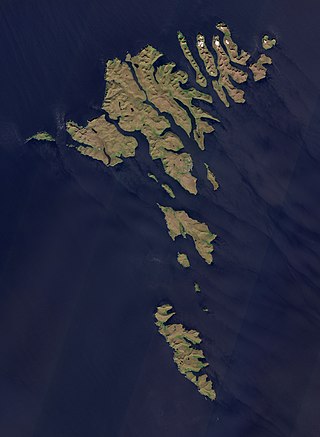
The Faroe Islands are an island group consisting of eighteen islands between the Norwegian Sea and the North Atlantic, about half-way between Iceland and Norway. Its coordinates are 62°N7°W. It is 1,393 square kilometres in area, and includes small lakes and rivers, but no major ones. There are 1,117 kilometres of coastline, and no land boundaries with any other country.

Greenland is located between the Arctic Ocean and the North Atlantic Ocean, northeast of Canada and northwest of Iceland. The territory comprises the island of Greenland—the largest island in the world—and more than a hundred other smaller islands. Greenland has a 1.2-kilometer-long (0.75 mi) border with Canada on Hans Island. A sparse population is confined to small settlements along certain sectors of the coast. Greenland possesses the world's second-largest ice sheet.

Ellesmere Island is Canada's northernmost and third largest island, and the tenth largest in the world. It comprises an area of 196,236 km2 (75,767 sq mi), slightly smaller than Great Britain, and the total length of the island is 830 km (520 mi).

Victoria Island is a large island in the Arctic Archipelago that straddles the boundary between Nunavut and the Northwest Territories of Canada. It is the eighth-largest island in the world, and at 217,291 km2 (83,897 sq mi) in area, it is Canada's second-largest island. It is nearly double the size of Newfoundland (111,390 km2 [43,010 sq mi]), and is slightly larger than the island of Great Britain (209,331 km2 [80,823 sq mi]) but smaller than Honshu (225,800 km2 [87,200 sq mi]). The western third of the island lies in the Inuvik Region of the Northwest Territories; the remainder is part of Nunavut's Kitikmeot Region. The population of 2,168 is divided among two settlements, the larger of which is Cambridge Bay (Nunavut) and the other Ulukhaktok.

The Arctic Archipelago, also known as the Canadian Arctic Archipelago, is an archipelago lying to the north of the Canadian continental mainland, excluding Greenland and Iceland.
Hans Island is an island in the centre of the Kennedy Channel of Nares Strait in the high Arctic region, split between the Canadian territory of Nunavut and the Danish autonomous territory of Greenland. The island itself is barren and uninhabited with an area of 130 hectares, measuring 1,290 by 1,199 metres, and a maximum elevation of 168.17 m (551.7 ft). Its location in the strait that separates Ellesmere Island of Canada from northern Greenland was for years a border dispute, the so-called Whisky War between the two countries of Canada and Denmark. Hans Island is the smallest of three islands in Kennedy Channel off the Washington Land coast; the others are Franklin Island and Crozier Island. The strait at this point is 35 km (22 mi) wide, placing the island within the territorial waters of both Canada and Denmark (Greenland). A 1,280-metre-long (4,200 ft) border traverses the island.

Alert, in the Qikiqtaaluk Region of Nunavut, Canada, is the northernmost continuously inhabited place in the world, on Ellesmere Island at latitude 82°30'05" north, 817 km (508 mi) from the North Pole. It takes its name from HMS Alert, which wintered 10 km (6.2 mi) east of the present station, off what is now Cape Sheridan, in 1875–1876.

This is a list of the extreme points of North America: the points that are highest and lowest, and farther north, south, east or west than any other location on the continent. Some of these points are debatable, given the varying definitions of North America.

Kaffeklubben Island or Coffee Club Island is an uninhabited island lying off the northern shore of Greenland. It contains the northernmost undisputed point of land on Earth.

The Nimrod Glacier is a major glacier about 85 nautical miles long, flowing from the polar plateau in a northerly direction through the Transantarctic Mountains into the Ross Ice Shelf, Antarctica.
This is a list of the extreme points of The Americas, the points that are farther north, south, east or west than any other location on the continent. The continent's southernmost point is often said to be Cape Horn, which is the southernmost point of the Chilean islands. The Americas cross 134° of longitude east to west and 124° of latitude north to south.

Stonington Island is a rocky island lying 1.8 km (1.1 mi) northeast of Neny Island in the eastern part of Marguerite Bay off the west coast of Graham Land, Antarctica. It is 0.75 km (0.47 mi) long from north-west to south-east and 0.37 km (0.23 mi) wide, yielding an area of 20 ha. It was formerly connected by a drifted snow slope to Northeast Glacier on the mainland. Highest elevation is Anemometer Hill which rises to 25 m (82 ft).

Kane Basin is an Arctic waterway lying between Greenland and Canada's northernmost island, Ellesmere Island. It links Smith Sound to Kennedy Channel and forms part of Nares Strait. It is approximately 180 kilometres in length and 130 km at its widest.

Peary Land is a peninsula in northern Greenland, extending into the Arctic Ocean. It reaches from Victoria Fjord in the west to Independence Fjord in the south and southeast, and to the Arctic Ocean in the north, with Cape Morris Jesup, the northernmost point of Greenland's mainland, and Cape Bridgman in the northeast.

Cumberland Peninsula is a peninsula in the southeastern part of Baffin Island in Nunavut, Canada. It is located between 64°56' and 67°57' north latitude, and 61°56' to 68° west longitude. The Arctic Circle crosses the peninsula, with the Labrador Sea to the southeast, and the Davis Strait to the east, which lies between the peninsula and Greenland. The Cumberland Sound lies to the southwest, separating the Cumberland Peninsula from the Hall Peninsula, which is also part of Baffin Island.

Hall Basin is an Arctic waterway between Hall Land in Greenland to the east and Canada's northernmost island, Ellesmere Island, to the west.

Nioghalvfjerdsbrae, sometimes referred to as "79 N Glacier", is a large glacier located in King Frederick VIII Land, northeastern Greenland. It drains an area of 103,314 km2 (39,890 sq mi) of the Greenland Ice Sheet with a flux of 14.3 km3 (3.4 cu mi) per year, as measured for 1996. The glacier has two calving fronts where the glacier meets the ocean, separated by Hovgaard Island. In July 2020, the northern offshoot, the Spalte Glacier broke away from Nioghalvfjerdsbrae and completely disintegrated.
Kangerlussuaq Icefjord is a fjord in Avannaata municipality in northwestern Greenland.

The Canadian Arctic Rift System is a major North American geological structure extending from the Labrador Sea in the southeast through Davis Strait, Baffin Bay and the Arctic Archipelago in the northwest. It consists of a series of interconnected rifts that formed during the Paleozoic, Mesozoic and Cenozoic eras. Extensional stresses along the entire length of the rift system have resulted in a variety of tectonic features, including grabens, half-grabens, basins and faults.
