Bybee, Tennessee | |
|---|---|
 A farm in Bybee | |
 Bybee, Tennessee  Bybee, Tennessee | |
| Coordinates: 36°02′53″N83°10′46″W / 36.04806°N 83.17944°W | |
| Country | United States |
| State | Tennessee |
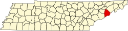
| County | Cocke |
| Elevation . [1] | 1,116 ft (340 m) |
| Time zone | UTC-5 (Eastern (EST)) |
| • Summer (DST) | UTC-4 (EDT) |
| ZIP code | 37713 |
| Area codes | 423, 865 |
| GNIS feature ID | 1305576 [1] |
Bybee is an unincorporated community in Cocke County, Tennessee, United States. [1] Its ZIP code is 37713. [2]
Bybee is the location of Briarwood Ranch Safari Park. [3]