Parrottsville, Tennessee | |
|---|---|
| Town of Parrottsville | |
 Former alignment of US Route 321 facing west at Tennessee State Route 340 south | |
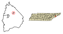 Location of Parrottsville in Cocke County, Tennessee. | |
| Coordinates: 36°00′30″N83°05′30″W / 36.00833°N 83.09167°W | |
| Country | United States |
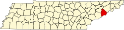
| State | Tennessee |
| County | Cocke |
| Settled | 1769 [1] |
| Incorporated | 1923 [2] |
| Named after | John Parrott (early settler) |
| Area | |
• Total | 0.74 sq mi (1.92 km2) |
| • Land | 0.74 sq mi (1.92 km2) |
| • Water | 0.00 sq mi (0.00 km2) |
| Elevation | 1,178 ft (359 m) |
| Population | |
• Total | 217 |
| • Density | 292.85/sq mi (113.09/km2) |
| Time zone | UTC-5 (Eastern (EST)) |
| • Summer (DST) | UTC-4 (EDT) |
| ZIP code | 37843 |
| Area code | 423 |
| FIPS code | 47-57040 [6] |
| GNIS feature ID | 2407078 [4] |
| Website | www |
Parrottsville is a town in Cocke County, Tennessee, United States. The population was 263 at the 2010 census. [7]