
Newcastle upon Tyne, or simply Newcastle, is a city and metropolitan borough in Tyne and Wear, England. It is England's northernmost metropolitan borough, located on the River Tyne's northern bank opposite Gateshead to the south. It is the most populous settlement in the Tyneside conurbation and North East England.

The Tyne Bridge is a through arch bridge over the River Tyne in North East England, linking Newcastle upon Tyne and Gateshead. The bridge was designed by the engineering firm Mott, Hay and Anderson, who later designed the Forth Road Bridge, and was built by Dorman Long and Co. of Middlesbrough. The bridge was officially opened on 10 October 1928 by King George V and has since become a defining symbol of Tyneside. It is ranked as the tenth tallest structure in Newcastle.

Cramlington is a town and civil parish in Northumberland. It is 6 miles north of Newcastle upon Tyne. The name suggests a probable founding by the Danes or Anglo-Saxons.

The Ark is an office building located in Hammersmith, London, England.

North Shields is a town in the borough of North Tyneside in Tyne and Wear, England. It is 8 miles (13 km) north-east of Newcastle upon Tyne and borders nearby Wallsend and Tynemouth.

Eldon Square is a shopping centre in Newcastle upon Tyne, England. It opened in 1976 and was built on the site of Old Eldon Square, a famous part of Georgian Newcastle designed by John Dobson in about 1824. This redevelopment, which left only the eastern terrace standing, has been criticised, with one writer calling it "the greatest single example of architectural vandalism in Britain since the war".

Ralph Erskine ARIBA was a British architect and planner who lived and worked in Sweden for most of his life.

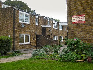
Byker is a district in the east of the city and metropolitan borough of Newcastle upon Tyne, in the county of Tyne and Wear, England. Home to the Byker Wall estate, made famous by TV series Byker Grove, Byker's population was recorded at 12,206 in the 2011 census. Byker is bordered by Heaton to the north and by Shieldfield to the north east. Until 1974 it was in Northumberland.

Sunderland is a railway and metro station in Sunderland, Tyne and Wear, England. It is on the Durham Coast Line, which runs between Middlesbrough and Newcastle, via Hartlepool. It is owned by Network Rail and managed by Northern Trains. Since 31 March 2002, the station has also been served by the Tyne and Wear Metro's Green Line.

The Quayside is an area along the banks (quay) of the River Tyne in Newcastle upon Tyne and Gateshead in Tyne and Wear, North East England, United Kingdom.

Benwell is an area in the West End of Newcastle upon Tyne, in the county of Tyne and Wear, England. Until 1974 it was in Northumberland.

Laing O'Rourke is a multinational construction company headquartered in Dartford, England. It was founded in 1978 by Ray O'Rourke. It is the largest privately owned construction company in the United Kingdom.

The Heygate Estate was a large housing estate in Walworth, Southwark, South London, comprising 1,214 homes. The estate was demolished between 2011 and 2014 as part of the urban regeneration of the Elephant & Castle area. Home to more than 3,000 people, it was situated adjacent to Walworth Road and New Kent Road, and immediately east of the Elephant & Castle road intersection. The estate was used extensively as a filming location, due in part to its brutalist architecture.
Cressingham Gardens is a council garden estate in Lambeth. It is located on the southern edge of Brockwell Park. It comprises 306 dwellings, a mixture of four, three and two-bedroom houses, and one-bedroom apartments. It was designed at the end of the 1960s by the Lambeth Borough Council Architect Edward Hollamby and second architect Roger Westman, and built at the start of the 1970s. In 2012 Lambeth Council proposed demolishing the estate, to replace the terraced houses by apartment blocks. Most of the apartments would then be for sale to the private sector. The residents, those in Lambeth who wish to prevent the gentrification of the borough, and those who want to conserve what they believe to be important architectural heritage, are campaigning to prevent its demolition.

Public housing in the United Kingdom, also known as council housing or social housing, provided the majority of rented accommodation until 2011, when the number of households in private rental housing surpassed the number in social housing. Dwellings built for public or social housing use are built by or for local authorities and known as council houses. Since the 1980s non-profit housing associations became more important and subsequently the term "social housing" became widely used, as technically council housing only refers to housing owned by a local authority, though the terms are largely used interchangeably.
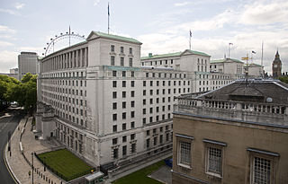
The Ministry of Defence Main Building or MOD Main Building, also known as MOD Whitehall or originally as the Whitehall Gardens Building, is a grade I listed government office building located on Whitehall in London. The building was designed by E. Vincent Harris in 1915 and constructed between 1939 and 1959 on part of the site of the Palace of Whitehall, specifically Pelham House, Cromwell House, Montagu House, Pembroke House and part of Whitehall Gardens. It was initially occupied by the Air Ministry and the Board of Trade before becoming the current home of the Ministry of Defence in 1964.
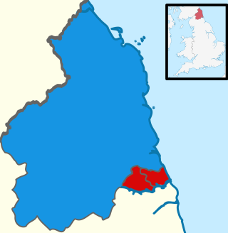
The inaugural North of Tyne mayoral election was held on 2 May 2019 to elect the first Mayor of the North of Tyne. The area is made up of Newcastle upon Tyne, North Tyneside and Northumberland. Subsequent elections will be held every five years.

Slum clearance in the United Kingdom has been used as an urban renewal strategy to transform low-income settlements with poor reputation into another type of development or housing. Early mass clearances took place in the country's northern cities. Starting from 1930, councils were expected to prepare plans to clear slum dwellings, although progress stalled upon the onset of World War II.
The Veronica Rudge Green Prize in Urban Design is a biannual award that acknowledges remarkable urban design projects that include multiple buildings or an open space, improve the quality of urban life, and have a humane and beneficial impact. It is awarded by Harvard University's Graduate School of Design and was founded in 1986 to mark the 350th anniversary of Harvard University and the 50th anniversary of the Graduate School of Design.

Karbon Homes is a housing association in the United Kingdom, formed in 2017 as a merger between Cestria Community Housing and Isos Housing. The organisation owns more than 30,000 properties and houses over 80,000 people in Northern England.


