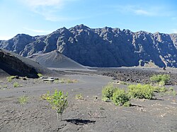
Chã das Caldeiras is a small community of approximately 700 inhabitants in the crater of the volcano Pico do Fogo on the island of Fogo, Cape Verde. The village consists of two main parts: Portela and Bangaeira, founded in 1920 and 1917, respectively. At an elevation of about 1,700 meters, it is the highest village in Cape Verde. It is part of the municipality of Santa Catarina do Fogo. The main organizing body in the village is the Associação dos Agricultores de Chã, which holds considerable sway over the local economy. Chã is the only area in Cape Verde that grows significant quantities of grapes and produces export-quality wines.
Santa Catarina do Fogo is a concelho (municipality) of Cape Verde. Situated in the southeastern part of the island of Fogo, it covers 32% of the island area, and is home to 14% of its population. Its seat is the city Cova Figueira. The Municipality of Santa Catarina do Fogo was created in 2005; before 2005, it was a parish of the Municipality of São Filipe.

Achada Furna is a settlement in the southern part of the island of Fogo, Cape Verde. It is situated 15 km east of the island capital São Filipe. At the 2010 census its population was 495. Its elevation is about 870 meters. Nearby places include Cabeça Fundão to the north, Figueira Pavão to the east, Fonte Aleixo to the south and Monte Largo to the west.

Cova Figueira is a city in the southeastern part of the island of Fogo, Cape Verde. In 2010 its population was 1,230, making it the most populated place in the municipality. It is situated 22 km east of the island capital São Filipe. Since 2005, it serves as the seat of Santa Catarina do Fogo Municipality. Its elevation is 480 meters above sea level. The volcano Pico do Fogo is 7.7 km to the northwest. Nearby places include Figueira Pavão in the southwest, Mãe Joana and Estância Roque in the west and Tinteira in the north. Cova Figueira was elevated to a city in 2010.
Lomba is a settlement in the northwestern part of the island of Fogo, Cape Verde. In 2010 its population was 731. It is situated 10 km northeast of the island capital São Filipe.
Lagariça is a settlement in the western part of the island of Fogo, Cape Verde. It is situated 6 km northeast of the island capital São Filipe. One of its localities is named Coxo.
Figueira Pavão is a settlement in the southeastern part of the island of Fogo, Cape Verde. In 2010 its population was 320. It is situated 3 km southwest of Cova Figueira and 20 km east of the island capital São Filipe. Nearby settlements are Achada Furna to the west and Estância Roque to the north.
Monte Grande is a settlement in the central part of the island of Fogo, Cape Verde. It is situated at about 900 m in elevation, 10 km east of the island capital São Filipe. In 2010 its population was 743. Nearby places include Monte Largo to the southeast, Patim to the southwest and Miguel Gonçalves to the northwest.

Fonte Aleixo is a settlement in the southern part of the island of Fogo, Cape Verde. It is situated 3 km south of Achada Furna and 16 km southeast of the island capital São Filipe. In 2010 its population was 401.
Estância Roque is a settlement in the eastern part of the island of Fogo, Cape Verde. In 2010 its population was 411. It is situated 3 km west of Cova Figueira and 19 km east of the island capital São Filipe. Nearby places include Figueira Pavão in the south and Cabeça Fundão in the northwest.
Curral Grande is a settlement in the western part of the island of Fogo, Cape Verde. It is situated 8 km northeast of the island capital São Filipe. In 2010 its population was 398. The village sits at 289 meters above sea level.
Galinheiro is a settlement in the northwestern part of the island of Fogo, Cape Verde. In 2010 its population was 877. It is situated 2 km northeast of Ponta Verde, 2.5 km southwest of São Jorge and 13 km northeast of the island capital São Filipe.

Nossa Senhora da Conceição is a freguesia of Cape Verde. It covers the southern part of the municipality of São Filipe, on the island of Fogo. The freguesia consists of the following settlements:

Cabeça dos Tarrafes is a village in the eastern part of the island of Boa Vista, Cape Verde. The village is located about 2 km south of Fundo das Figueiras and 21 km southeast of the island capital of Sal Rei. It is one of the easternmost communities in Cape Verde.
Cabeça, the Portuguese word for head, may refer to:
Feijoal is a village on the island of Fogo, Cape Verde. It lies close to the town Mosteiros, at about 220 meters elevation. Its population was 435 at the 2010 census. The main festival in the settlement is Saint Anthony which is on June 13.

Funco is a traditional Capeverdean house that originated from Africa. Its houses are mainly founded on the islands of Fogo, Santiago and Maio, it is represented in Guinea-Bissau. Its circular form are made of different kinds of rock. The conical roof is made up thatch of palm leaves and has only a piece.

Tinteira is a settlement in the eastern part of the island of Fogo, Cape Verde. It is situated 4 km north of Cova Figueira, 5 km south of Relva and 22 km east of the island capital São Filipe. At the 2010 census its population was 410. Its elevation is 300 meters. Tinteira consists of the localities Tinteira, Cova Matinho and Cutelo Capado.
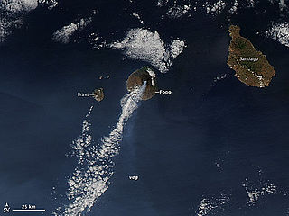
The 2014–15 eruption of Fogo, the eruption of the Pico do Fogo, was a minor eruption that began on 23 November 2014, it was less intensified on December 8, it became intensified on December 19 but decreased and would be finished on February 8. It was the next volcanic activity in 19 years and was the longest since the 1857 eruption, longer than the last previous two eruptions. According to the Volcanic Explosivity Index, it was measured 3, the first since records began.
Luzia Nunes is a settlement in the southwestern part of the island of Fogo, Cape Verde. It is situated 1.5 km west of Patim, 2 km southeast of Vicente Dias and 7 km southeast of the island capital São Filipe. At the 2010 census its population was 438.