Cairngaan

Last updated

Cairngaan
Dumfries and Galloway UK location map.svg
Red pog.svg
Cairngaan
Location within Dumfries and Galloway
OS grid reference NX128319
Council area
Lieutenancy area
Country Scotland
Sovereign state United Kingdom
Post town STRANRAER
Postcode district DG9
Police Scotland
Fire Scottish
Ambulance Scottish
UK Parliament
Scottish Parliament
List of places
UK
Scotland
54°39′00″N4°54′06″W / 54.65009°N 4.90154°W / 54.65009; -4.90154 Coordinates: 54°39′00″N4°54′06″W / 54.65009°N 4.90154°W / 54.65009; -4.90154

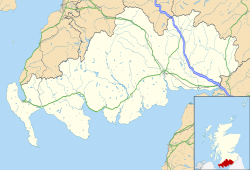
Cairngaan, Wigtownshire, is the southmost settlement in Scotland. The hamlet of Cairngaan lies just north of the Mull of Galloway (which contains Scotland's most southerly point, and a lighthouse, but no villages) on the B7041, after a turn-off from the B7065 road. The village is at the extreme end of the B7401. As a result of Cairngaan's southerly location, the town lies south of the English cities of Newcastle upon Tyne, Sunderland and Carlisle.

Contents

Nearby settlements include Drummore and Kirkmaiden to the near north. Around 18 miles (29 km) away is Stranraer and the ferry to Northern Ireland.
See also

Related Research Articles

Dumfries and Galloway Council area of Scotland

Dumfries and Galloway is one of 32 unitary council areas of Scotland and is located in the western Southern Uplands. It comprises the historic counties of Dumfriesshire, Kirkcudbrightshire, and Wigtownshire, the latter two of which are collectively known as Galloway. The administrative centre and largest settlement is the town of Dumfries. The second largest town is Stranraer, 75 miles to the west on the Irish Sea coast.

Whiting Bay Village in Scotland

Whiting Bay is a village located on the Isle of Arran in the Firth of Clyde, Scotland four miles south of Lamlash and eight miles south of Brodick. It is the island of Arran's third largest settlement behind Lamlash and Brodick. It is called after the bay near the southern end of Arran's east coast that the settlement sits on.

Port William, Dumfries and Galloway Human settlement in Scotland

Port William is a fishing village in the parish of Mochrum in the historical county of Wigtownshire, Dumfries and Galloway, in Scotland with a population of approximately 460.

Dunnet Head

Dunnet Head is a peninsula in Caithness, on the north coast of Scotland. Dunnet Head includes the most northerly point of both mainland Scotland and the island of Great Britain.

Crianlarich Human settlement in Scotland

Crianlarich is a village in Stirling council area and in the registration county of Perthshire, Scotland, around 6 miles (10 km) north-east of the head of Loch Lomond. The village bills itself as "the gateway to the Highlands".

Saint Andrew, Barbados Parish in Barbados

Saint Andrew is one of eleven parishes of Barbados. It is situated in the northern area in the country.

Saint James, Barbados Parish in Barbados

The parish of Saint James is an area located in the western central part of the country of Barbados. Increasingly St. James is becoming known as the playground of the rich and famous, and as a haven for sun-starved tourists with its up-market hotel resorts.

Kenmore, Perth and Kinross Human settlement in Scotland

Kenmore is a small village in Perthshire, in the Highlands of Scotland, located where Loch Tay drains into the River Tay.

Stora Alvaret

Stora Alvaret is an alvar, a barren limestone terrace, in the southern half of the island of Öland, Sweden. Stora Alvaret is a dagger shaped expanse almost 40 kilometres (25 mi) long and about 10 kilometres (6 mi) at the widest north end. The area of this formation exceeds 260 square kilometres (100 sq mi), making it the largest such expanse in Europe and comprising over one fourth of the land area of the island.

Walls, Shetland Human settlement in Scotland

Walls, known locally as Waas,, is a settlement on the south side of West Mainland, Shetland Islands in Scotland. The settlement is at the head of Vaila Sound and sheltered even from southerly storms by the islands of Linga and Vaila. Walls is within the parish of Walls and Sandness.

Spean Bridge Village in Kilmonivaig, Lochaber, Scotland

Spean Bridge is a village in the parish of Kilmonivaig, in Lochaber in the Highland region of Scotland.

Newtyle Human settlement in Scotland

Newtyle is a village in the west of Angus, Scotland. It lies eleven miles north of Dundee in the southwest of Strathmore, between Hatton Hill and Newtyle in the Sidlaws. The village sits on gently sloping ground with a northwest aspect. The main communication link is the B954 road. The population was about 800 as of 2004.

Whitehills Human settlement in Scotland

Whitehills is a small fishing village in Banffshire, Scotland, that lies three miles west of Banff on the Moray Firth. It forms part of the Aberdeenshire council area.

This is a list of the extreme points and extreme elevations in Scotland.

Port of Menteith Village in Scotland

Port of Menteith is a village and civil parish in the Stirling district of Scotland, the only significant settlement on the Lake of Menteith. It was established as a burgh of barony, then named simply Port, in 1457 by King James III of Scotland. It lay in the former county of Perthshire.

Gedintailor Human settlement in Scotland

Gedintailor is a crofting village, lying on the shores of the Narrows of Raasay on the east coast of the island of Skye in Scotland and is in the council area of Highland.

Lowther Hills Geographical object in Dumfries and Galloway, Scotland, UK

The Lowther Hills, also sometimes known as the Lowthers, are an extensive area of hill country in the Southern Uplands of Scotland, though some sub-ranges of hills in this area also go under their own local names - see "Hillwalking" below. They form a roughly rhomboidal or lozenge shape on the map with the acute angles being to north and south. It has river valleys along its boundaries to north east (Clydesdale) and south west (Nithsdale) which carry the two largest arterial routes northwards into the west side of the Central Belt of Scotland. A string of small towns have long since developed along these routes. Most of the Lowther Hills lie in the Administrative County of Dumfries and Galloway, though part in the administrative county of South Lanarkshire moves into them around the village of Leadhills and the Daer Reservoir.

Wellbank Human settlement in Scotland

Wellbank is a village in Angus, Scotland. It lies approximately three miles north of Dundee, on the B978 road.

Blairingone Village in Perth and Kinross, Scotland

Blairingone is a village in Perth and Kinross, Scotland. It lies on the A977 road at its intersection with Vicar's Bridge Road near the extreme south-westerly point of the region, approximately 3 miles southeast of Dollar. The Arndean agricultural estate lies about 1 mile northeast, near the River Devon.

Ferryden Human settlement in Scotland

Ferryden is a village in Angus, Scotland in the community council area of Ferryden & Craig. It lies southerly adjacent to the town of Montrose on the south bank of the South Esk and is considered a fringe locality of Montrose, being connected to the latter by the former Rossie Island, now home to shipping facilities and Montrose Port Authority.

References