
Macerata Feltria is a comune (municipality) in the Province of Pesaro e Urbino in the Italian region Marche, located about 90 kilometres (56 mi) west of Ancona and about 40 kilometres (25 mi) southwest of Pesaro.
Apiro is a comune (municipality) in the Province of Macerata in the Italian region Marche, located about 40 kilometres (25 mi) southwest of Ancona and about 25 kilometres (16 mi) northwest of Macerata.

Appignano is a comune (municipality) in the Province of Macerata in the Italian region Marche, located about 35 kilometres (22 mi) southwest of Ancona and about 20 kilometres (12 mi) northwest of Macerata.
Bolognola is a comune (municipality) in the Province of Macerata in the Italian region Marche, located about 70 kilometres (43 mi) southwest of Ancona and about 40 kilometres (25 mi) southwest of Macerata.
Camporotondo di Fiastrone is a comune (municipality) of about 580 inhabitants in the Province of Macerata in the Italian region Marche, located about 60 kilometres (37 mi) southwest of Ancona and about 25 kilometres (16 mi) southwest of Macerata.
Castelsantangelo sul Nera is a comune (municipality) in the Province of Macerata in the Italian region of Marche, located about 90 kilometres (56 mi) southwest of Ancona and about 50 kilometres (31 mi) southwest of Macerata. The source of the Nera River is located in the communal territory.
Cessapalombo is a comune (municipality) in the Province of Macerata in the Italian region Marche, located about 60 kilometres (37 mi) southwest of Ancona and about 25 kilometres (16 mi) southwest of Macerata.
Colmurano is a comune (municipality) in the Province of Macerata in the Italian region of Marche, located about 50 kilometres (31 mi) southwest of Ancona and about 15 kilometres (9 mi) southwest of Macerata.

Fiastra is a comune (municipality) in the Province of Macerata in the Italian region Marche, located about 70 kilometres (43 mi) southwest of Ancona and about 40 kilometres (25 mi) southwest of Macerata.
Gagliole is a comune (municipality) in the Province of Macerata in the Italian region Marche, located about 60 kilometres (37 mi) southwest of Ancona and about 30 kilometres (19 mi) west of Macerata.
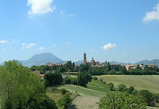
Loro Piceno is a comune (municipality) in the Province of Macerata in the Italian region Marche, located about 50 kilometres (31 mi) south of Ancona and about 15 kilometres (9 mi) south of Macerata on a hill near the Fiastra stream.
Monte Cavallo is a comune (municipality) in the Province of Macerata in the Italian region Marche, located about 80 kilometres (50 mi) southwest of Ancona and about 45 kilometres (28 mi) southwest of Macerata.
Muccia is a comune (municipality) in the Province of Macerata in the Italian region Marche, located about 70 kilometres (43 mi) southwest of Ancona and about 40 kilometres (25 mi) southwest of Macerata. As of 31 December 2004, it had a population of 925 and an area of 25.6 square kilometres (9.9 sq mi).
Pieve Torina is a comune (municipality) in the Province of Macerata in the Italian region Marche, located about 70 kilometres (43 mi) southwest of Ancona and about 45 kilometres (28 mi) southwest of Macerata.

Pollenza is a comune (municipality) in the Province of Macerata in the Italian region Marche, located about 40 kilometres (25 mi) southwest of Ancona and about 9 kilometres (6 mi) southwest of Macerata. As of 31 December 2004, it had a population of 6,086 and an area of 39.5 square kilometres (15.3 sq mi).
Sarnano is a comune (municipality) in the Province of Macerata in the Italian region Marche, located about 70 kilometres (43 mi) southwest of Ancona and about 30 kilometres (19 mi) southwest of Macerata.
Sefro is a comune (municipality) in the Province of Macerata in the Italian region Marche, located about 70 kilometres (43 mi) southwest of Ancona and about 45 kilometres (28 mi) southwest of Macerata. As of 31 December 2004, it had a population of 453 and an area of 42.5 square kilometres (16.4 sq mi).

Serrapetrona is a comune (municipality) in the province of Macerata in the Italian region Marche, located about 60 kilometres (37 mi) southwest of Ancona and about 25 kilometres (16 mi) southwest of Macerata.
Serravalle di Chienti is a comune (municipality) in the Province of Macerata in the Italian region Marche, located about 80 kilometres (50 mi) southwest of Ancona and about 50 kilometres (31 mi) southwest of Macerata. It is crossed by the Chienti river. The communal territory is largely mountainous with numerous woods and pastures.
Ùssita is a comune (municipality) in the Province of Macerata in the Italian region Marche, located about 80 kilometres (50 mi) southwest of Ancona and about 45 kilometres (28 mi) southwest of Macerata.


